
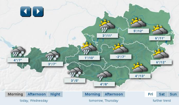
Weather
The introduction lecture is addressed to users of PPS wanting to update their application, but also to prospective new users.
Length: 66 minutes.
The EUMETSAT SAF to support Nowcasting (NWCSAF) develops two software packages, one for geostationary imagery and one for polar satellite imagery. Both packages retrieve cloud and other parameters relevant for nowcasting and other applications relying on cloud detection. For more information see www.nwcsaf.org
The Polar Platform System (PPS) software package retrieves information on clouds and precipitation from Terra, Aqua, MetOp and S-NPP. The recent release of PPS v2018 features also a number of scientific and technical updates.
The introduction lecture is addressed to users of PPS wanting to update their application, but also to prospective new users.
Go to Webcast, scientific... (mp4)
Go to Webcast, technical... (mp4)
Presentations (PDF):
PPS v2018 Scientific Introduction
PPS v2018 Technical Instruction
Silvia Puca introduces the H-SAF and its products.
Length: 23 minutes.
H SAF started in 2005 and aims to provide remote sensing estimates of relevant hydrological parameters: instantaneous rain rate and cumulated rainfall, soil moisture at surface and in the root zone, snow cover and water equivalent. The project involves experts from 12 national meteorological and hydrological European Institutes of Austria, Belgium, Bulgaria, Finland, France, Germany, Hungary, Italy, Poland, Romania, Slovakia and Turkey, and from ECMWF.
The H SAF main objectives are: to provide new satellite-derived products (precipitation, snow parameters and soil moisture) from existing and future satellites with sufficient time and space resolution to satisfy the needs of operational hydrology, and to perform independent validation in order to assess the usefulness of the new products for fighting against floods, landslides, avalanches, and evaluating water resources.
Stefania Camica and Lucca Brocca describe the theoretical background for using satellite SM products in flood prediction.
Length: 19+24 minutes.
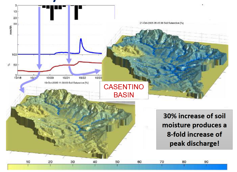
Satellite soil moisture (SM) products have been largely used for flood prediction. The knowledge of initial soil moisture conditions before a rainfall event is critical to determine the magnitude of a flood event. The presentation will describe the theoretical background for using satellite SM products in flood prediction, and will show examples for understanding the critical role of initial soil moisture for predicting floods.
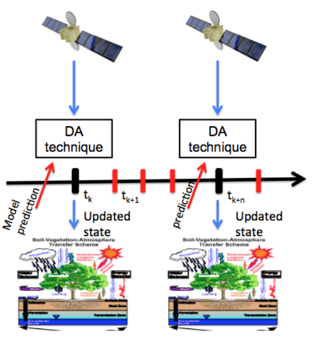
Simone Gabellani and Fabio Delogu describe how satellite soil moisture can be used in hydrological modelling trough data assimilation.
Length: 37+27 minutes.
The reliable estimation of hydrological variables in space and time is of fundamental importance in hydrology to improve the flood predictions and hydrological cycle description. Nowadays remotely sensed data can offer a chance to improve hydrological models especially in environments with scarce ground-based data. The presentation describes how satellite soil moisture can be used in hydrological modelling trough data assimilation.

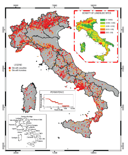
Nicola Berni presents the impact of soil moisture products for flood and land slide warning.
Length: 17 minutes.
Umbria Region Civil Protection Early Warning center (Central Italy) is in charge of alerting and monitoring critical events for Civil Protection purposes (mainly landslides and floods). In last ten years the office has used, in cooperation with national research institutes, satellite data to improve modeling/forecasting tools performances, monitoring activities about possible impacts of severe rainfall events able to trigger floods and landslides at regional scale. In fact, the estimation of the soil water content has proved to be a key parameter for better forecast models implementation both for landslide than for flood risk issues.
Silvia Puca presents how satellite products impact the efficiency of hydro-meteorological warning.
Length: 28 minutes.
Many severe meteorological events occurred in Europe during the last decade and caused casualties and damages to the historical heritage and natural environment. Protection of civilians and safeguard of the territory are the kay mandates of a civil Protection (CP) agency. This is achieved through activities that mitigate hydro-meteorological risks, such as flooding and droughts. European CP agencies, supported by meteorological and hydrological institutes, aim to assess risk scenarios, to monitor and supervise events and risk levels, providing early warning to National and local authorities.
Near real time accurate estimations of hydrological variables such as precipitation and soil moisture are invaluable to the CP agencies, enable them to issue early warnings and plan for disaster relief at the local level.
Besides measurements of key hydrological variables by ground-based instruments, often affected by a limited spatial coverage, advanced satellite-based precipitation and soil moisture products developed within different international programs as H SAF, are available and accessible to users in near-real time.
In this study, recent severe meteorological events are selected in order to understand how the main satellite product characteristics, i.e. accuracy, spatial pattern and resolution, update frequency and latency, impact the efficiency of a hydro-meteorological early warning system at a local level in an operational framework.
Lauryna Sidlauskaite talks about the challenges of winter road weather forecasts in view of climate change.
Length: 39 minutes.
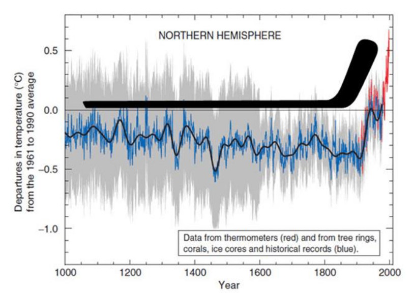
Climate change is almost literally the "hot" topic of today. Scientists agree that cars with combustion engines are one of the main sources of greenhouse gasses, however, with such vastly growing world economy, transportation of goods and people is essential. Thus, certain measures must be and are being made to reduce their negative effect on climate.
Humanity has reached a point in time, when even if greenhouse gas emissions could be reduced to pre-industrial times it will not stop the human-induced climate change and the effects of it will be felt for decades or even centuries to come. Therefore, we’re compelled to know and understand what to expect from road weather, especially in winter seasons.
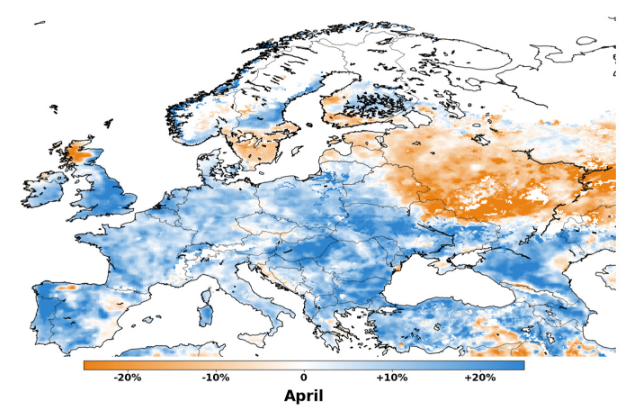
In this session, the problem of lack of specific climate forecasts for winter road weather will be discussed and future climate projections for road weather patterns will be presented with Lithuania as an example. The study in question involved regular climate forecasts for 21st century for several RCPs, downscaling of data to fit Lithuania and formation several statistical indices, that better describe road weather for road maintenance workers and road users. Using the indices allows a better understanding on what’s to come and how climate change will impact road weather in the 21st century.
Estibaliz Gascon presents the IFS ensemble forecasts from ECMWF that provides an instantaneous precipitation type output variable.
Length: 37 minutes.
One of the greatest difficulties facing forecasters during the cool season is the correct determination of precipitation type, especially with temperatures close to freezing point. There are numerous sources of uncertainty in precipitation type forecasts which is why mixed phases are not well predicted. These uncertainties are difficult to reduce but can potentially be quantified by the use of ensembles.
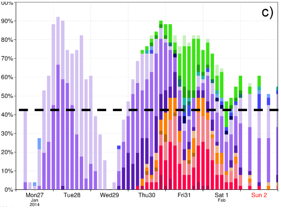
The Integrated Forecast System (IFS) ensemble forecasts (ENS) from ECMWF provide an instantaneous precipitation type (ptype) output variable that describes 6 types of precipitation at the surface: rain, freezing rain, snow, wet snow, sleet or ice pellets (plus dry). As part of ECMWF's contribution to the ANYWHERE European project, two new products were developed. These are the most probable precipitation type, shown on map format, and the instantaneous probabilities of different types, shown for a given site. The first of these shows which type is most probable whenever the probability of some precipitation is >50%. The second product depicts the temporal evolution of probabilities for a specific location in bar chart format, classified also according to three categories of instantaneous precipitation rate. These new instantaneous probabilistic products will be shown through an experiment reproducing the freezing rain case study in Slovenia in 2014.
Jean Marc Moisselin presents methods to detect IWC from satellite data.
Length: 45 min
Author: Jean-Marc Moisselin (Météo-France)
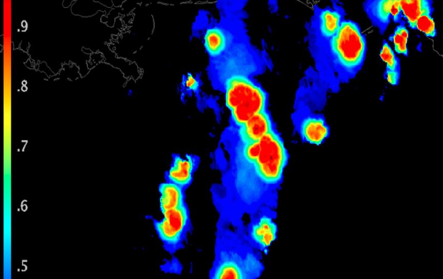
Large amount of ice particle may cause erroneous aircraft probe measurement and damage aircraft engines. The ice crystals are generally located near cores of deep convection and associated cirrus anvils, at high altitude and in tropical areas. The understanding of the phenomena and its forecast are a key issue for aviation. There are several methods to detect clouds associated with ice crystal icing: MSG-CPP High IWC Mask, DARDAR, PHIWC, Alpha, RDT(detects and tracks convective systems).
A series of fields experiment in tropical regions have been conducted separately or conjointly by HAIC and HIWC projects. During HAIC campaigns, RDT has been provided on an operational basis through dedicated MétéoFrance processing chains. Qualitative and quantitative studies provided reasonably good results, especially in terms of probability of detection.
A new day-time attribute (adapted from MSG-CPP High IWC Mask algorithm) has been implemented in RDT v2016. Now RDT is produced globally by using five geostationary satellites, which in turn increased operational applications. New generation of satellites and the feedback on products performance will help to improve retrieval of the hazard and to define future research fields.
Andreas Frank gives a short overview about ZAMG special products for winter road conditions.
Length: 26 minutes.
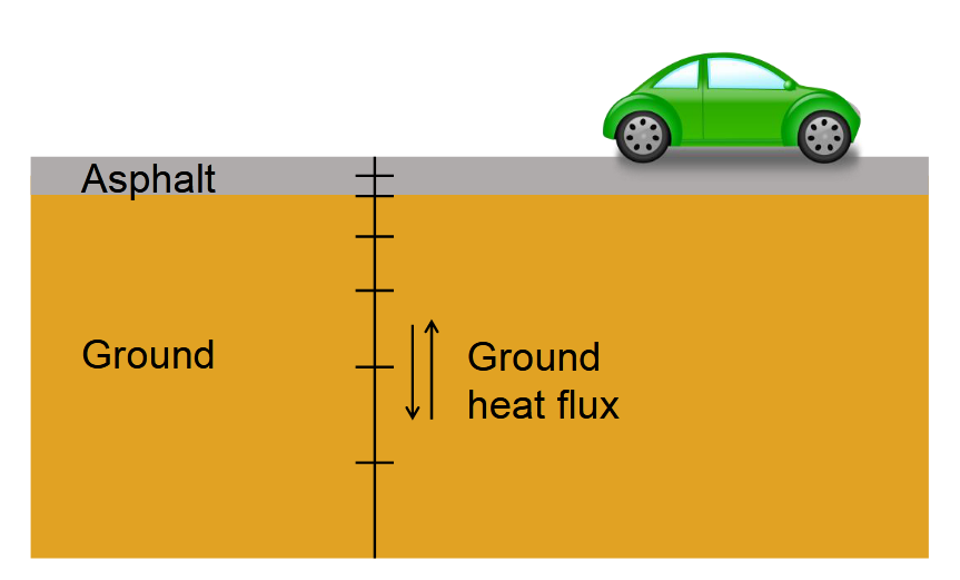
During winter season we have a lot of additional products dealing with road weather, especially road conditions (snow, ice, hoarfrost,...). The talk will give a short overview about our special products, what are the differences to a normal forecast and point out some problems in forecasting special parameters in the alpine region. Additionally you will get some information about our special training services for road maintainance workers and also you will get a short overview about our internet portal, which we provide for our customers.
Virve Karsisto describes the currently used road weather model in Finland.
Length: 25 minutes.
Finnish Meteorological Institute’s (FMI) road weather model has been in operational use for almost 20 years. The main outputs of the model are road surface temperature and amounts of water, snow and ice on the road. Based on these values, the model determines also the road condition (e.g. wet, icy or snowy), calculates friction and gives index for overall driving conditions (normal, difficult, very difficult). The forecasts help in the road maintenance decision making and give useful information to the road users about the driving conditions. In the actual forecast phase, the input is obtained from forecast edited by duty meteorologist.
There are several things that know about the model behavior. For example, the model is very dependent of the driving forecast. The typical errors in the input data will also present themselves in the road weather forecast. In addition, the present model assumes open sky conditions and doesn't take into account the openness of the surroundings. This can cause error to the forecasts for example in forested areas. The model aims to improve the first forecast hours by utilizing a method called coupling. This correction is used during the forecast phase so that its effect reduces as the forecast advances. Although coupling improves the forecast in average, in some situations it might not work as intended.
Elina Tuhkalainen treats the formation and dissipation of fog at airports in Finland.
Length: 35 min
Author: Elina Tuhkalainen (FMI)
In this presentation formation and dissipation of fog and stratus will be treated. The presenters will also address how these phenomena occur around the year and how they affect the services at the airports in Finland.