
Weather
Maria Putsay analyses different convective cells with Radar and lightning data.
Length: 50 minutes.
Detailed analyses of various types of storms using remote sensing (satellite, radar, lightning), in-situ and NWP data will be presented. Five cases for thunderstorms occurring in the Carpathian Basin were studied. We tracked the storms, to analyse the storms' temporal and spatial evolution and to see the possible relationships between lightning characteristics and severe convection development.
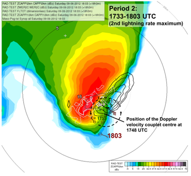
One frequent feature of supercell storms was that stronger lightning activity occurred in periods of mesocyclone intensification. This was probably also related to higher speed of updraft (or higher vertical acceleration) in these cases. Also in multicellular storms could be shown that the storm dynamics has major influence on the lightning activity (the number of lightning increased when signatures of strong convergence appeared in the Doppler radar velocity, though the radar reflectivity was not very high in that period).
Moist and conditionally unstable environments generally support development of severe storm with high electrification. However, some cases show that the storm’s dynamics and microphysics (e.g. distribution and type of the ice particle growth) can lead to large variability. For example, we found a case with tornadic thunderstorm, which exhibited much less lightning activity compared to other severe storms, despite of favourable environmental conditions concerning moisture or instability
José Lahuerta presents the NWCSAF products Convective Rainfall Rate (CRR) and CRR from cloud physical properties.
Length: 27 minutes.
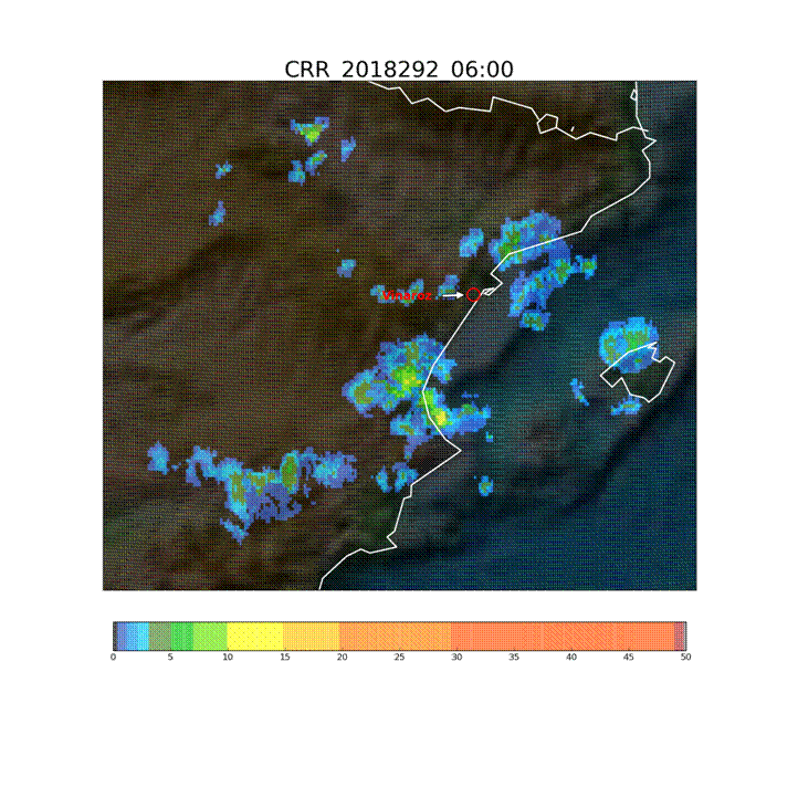
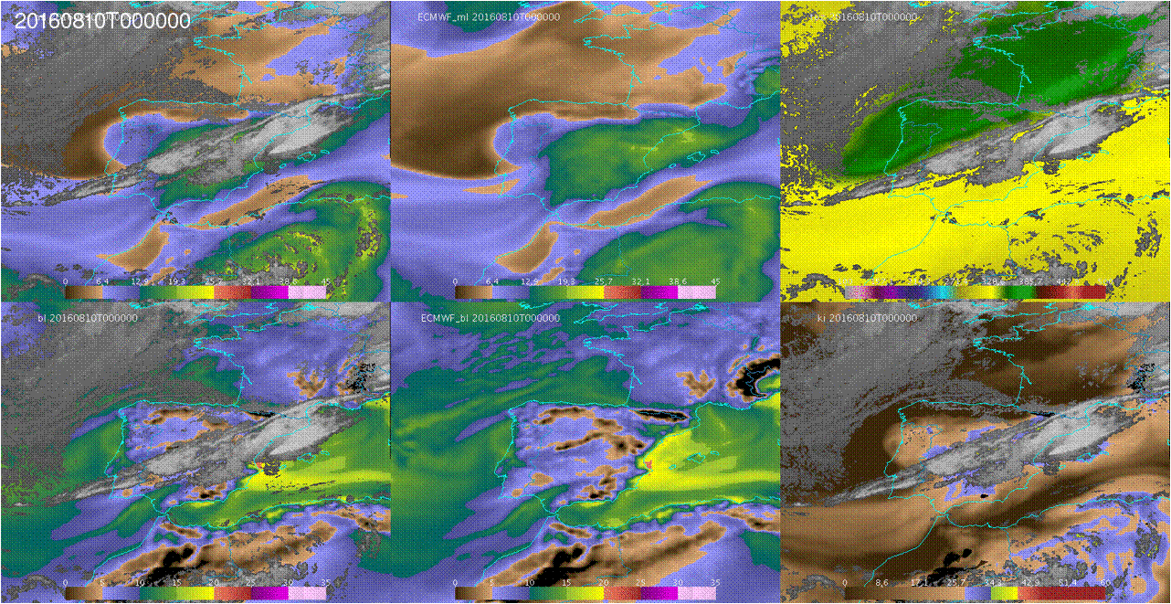
The Convective Rainfall Rate (CRR) and the Convective Rainfall Rate from Cloud Physical Properties (CRR-Ph) products are satellite derived rainfall products based on the MSG/SEVIRI channels and cloud top microphysical properties respectively. Both rainfall products have been developed within the NWC SAF context to provide with instantaneous rain rates and hourly accumulations associated to convective episodes. Last version of the NWCSAF software package includes a new version of the CRR-Ph for nigh time. CRR and CRR-Ph behaviour will be texted in different convective events.
Jean-Marc Moisselin presents the most recent developments of the NWCSAF convection products.
Length: 30 minutes.
Météo-France develops and contiuously upgrades CI (Convection Initiation) and RDT (Rapidly Developing Thunderstorm) products. Both have been developed in the framework of NWCSAF.
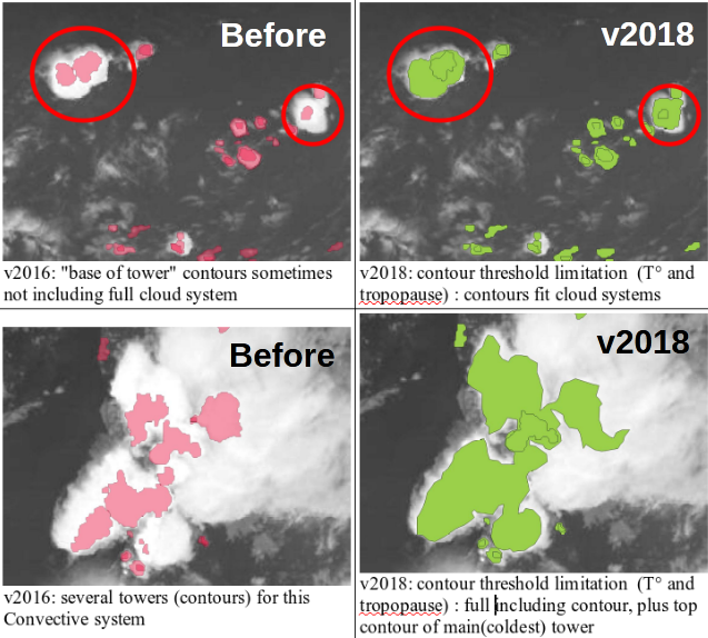
CI is a pixel-based product that provides the probability for a pixel to develop in thunderstorm. The last delivery, v2018, has reached the "pre-operational" status in Eumetsat sense thanks to new developments (e.g. use of microphysics), tuning and validation effort. RDT is an object-based product that aims to detect, track, characterize and forecast the convective cells. Version v2018, includes new features like lightning jumps detection and is highly flexible and configurable. Status is "operational". RDT is very useful for aviation end users.
Hervé le Gléau focuses on cloud top height and micro-physics that can be retrieved from the NWCSAF/GEO software.
Length: 25 minutes.
This talk focuses the cloud top height and microphysics that can be retrieved from the NWCSAF/GEO software. The algorithms will be outlined, the improvements implemented in the last version (v2018 just released this year) will be highlighted and some validation results will be shown. After having given some perspective for MTG-day1 release, a convective situation over France will be illustrated.
Miguel Martinez presents the new NWCSAF products iSHAI and PGE00.
Length: 26 minutes.
iSHAI (imaging Satellite Humidity and Instability) is the clear air product of the NWCSAF/GEO software that allows the monitoring in clear pixels of several key ingredients in convection; in addition, it allows to identify the regions where the numerical models used as input do not agree with the observation of the satellite. In version 2018, iSHAI has been adapted to Himawari satellites and it is being adapted for GOES-R class satellites.
PGE00 is an AEMET complementary tool that performs first the vertical, temporal and spatial interpolation (4D interpolation) of the profiles from NWP to the projection and time of the satellite images; allowing to generate for all the pixels the same fields that iSHAI. Second, PGE00 can be used to generate synthetic satellite images using RTTOV-12.1 in clear and cloudy conditions with a high degree of realism using the ECMWF model at hybrid levels. In addition to the comparison with real satellite images, synthetic images can be used to generate new developments and for preparation of MTG era through the generation synthetic MTG-FCI and MTG-IRS images.
The NWCSAF products and services for the future MTG-IRS will be also briefly presented.
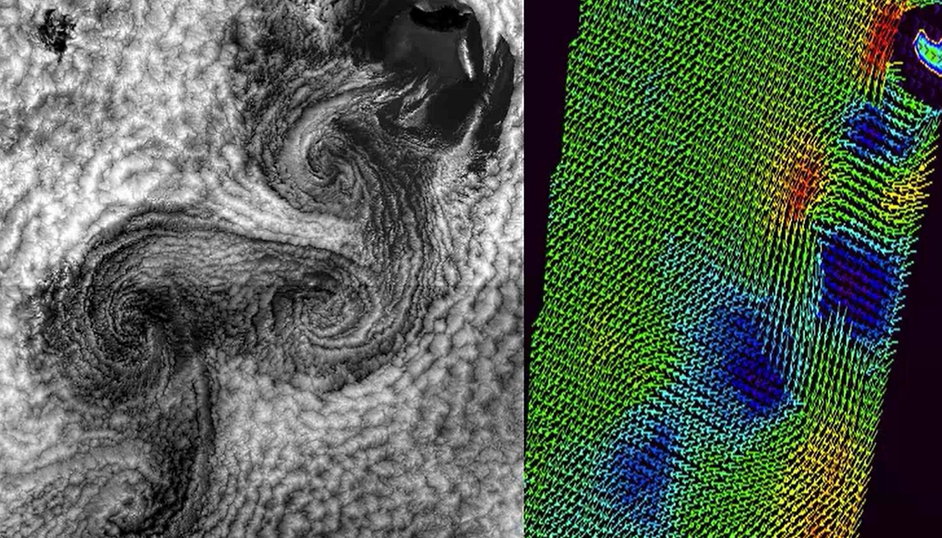
The lecture dels with the characteristics of satellites carrying instruments for measuring winds and with the logic behind the calculations of winds using satellites.
Length: 51 min
Author: Ad Stoffelen (KNMI)
The lecture deals with modelled winds and winds derived from instruments onboard satellites like Metop-A and Metop-B in low orbits around the Earth (polar orbits). Today's models are evolving at a rate that is faster than the increase of density of observations and that presents a problem for forecasts. Here stands the question 'Will meteorology continue to develop and improve?'. The lack of observed data is thus filled with the data from satellites, although this data also has its own constraints due to the way it is derived. In the lecture the characteristics of the satellites carrying instruments for measuring winds and waves will be explained and the logic behind the calculations of winds using satellites will be discussed.
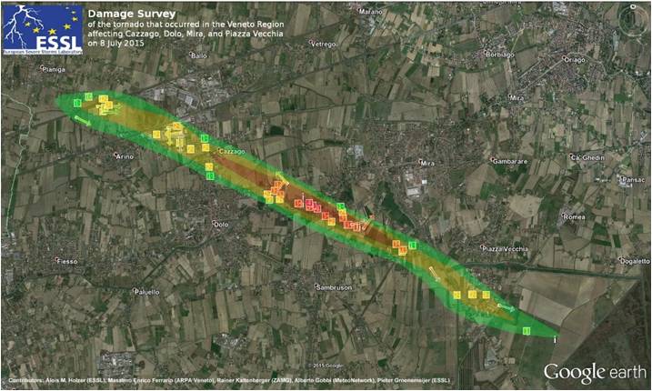
Georg Pistotnik talks about recent impact surveys, carried out by ZAMG in Austria.
Length: 36 minutes.
Windstorm and tornado intensity classification is usually done by assessing the inflicted damage, since reliable in-situ measurements are typically lacking. This presentation gives a practical introduction into windstorm and tornado damage assessment using the Fujita-(F)-Scale and the Damage Indicator (DI)-Degree of Damage (DoD) method. Recent site surveys, carried out by ZAMG in Austria, are presented and current developments towards an International Fujita-(IF)-Scale are briefly discussed.
Thomas Krennert talks about weather- and impact reports and a real-time feedback loop between forecasters and voluntary observers.
Length: 27 minutes.
Since the release of the WMO recommendations for impact based forecasts and warnings, reliable data about weather related effects on society and public life became increasingly important for operational forecasting. Particularly densely populated urban areas are vulnerable to the forces of convective weather hazards. In this regard, operational automatic station networks or remote sensing data cannot provide complete information about the ground truth like hail size, downburst related wind damage, flash floods or damage from lightning strikes. In order to fill this gap, targeted human assessment and observations are still needed. With the help of weather- and impact reports a real-time feedback loop between forecasters and voluntary observers can be established, to improve impact based warnings and thus to increase weather related disaster resilience and mitigation. In our presentation, we introduce the Austrian weather- and impact observation system "wettermelden.at" with its applications and furthermore a concept for the swift exchange of these reports on national and European levels.
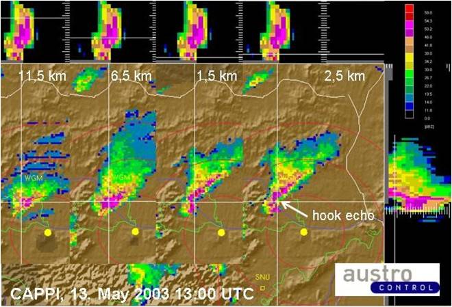
Georg Pistotnik talks about how convective cells organise to single-cells, multi-cells and super-cells.
Length: 31 minutes.
According to their degree of organization, thunderstorms can conceptually be divided into single cells, multicells and supercells. Organized storms, in particular supercells, are responsible for the large majority of severe convective weather like large hail and damaging wind gusts. They are favored by high latent instability and/or strong vertical wind shear and exhibit characteristic behavior in radar and satellite data. For nowcasting purposes and timely weather warnings, it is therefore crucial to recognize organized and severe thunderstorms in remote sensing data. This presentation focuses on key properties of this distinction and illustrates some characteristic examples.
Vera Meyer investigated the influence of synoptic flow regimes over Austria on typical thunderstorm parameters.
Length: 26 minutes.
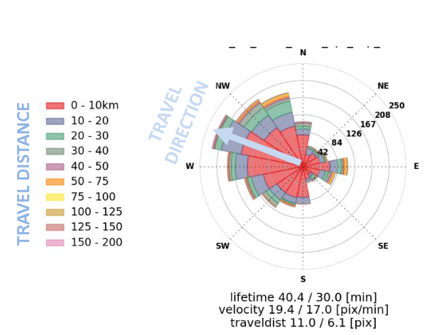
Since 2014 the Austrian thunderstorm nowcasting tool (A-TNT) monitors and nowcaststhunderstorm developments operationally based on 3D radar and lightning data. The algorithm employs an object-oriented approach observing and storing specific parameter attributes of the individual developments of convective cells. Radar data provide information about the internal precipitation structure and the probability of hail and lightning data about the electrical activity. A daily classification of the weather patterns based on a domestic development following Bissolli and Dittmann (2001) is available since 2004.
Based on a three years data sample the influence of synoptic flow regimes over Austria on typical thunderstorm parameters such as lifetime, cell size and core height, maximum and mean lightning stroke rate has been investigated as well as local thunderstorm frequencies and preferred storm paths.
Alberto de Lozar compares different cloud micro-physical schemes to better forecast thunderstorms.
Length: 25 minutes.
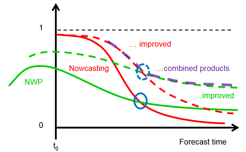
The goal of the SINFONY project of Deutscher Wetterdienst is to complement, refine and improve the methods of nowcasting (NWC) and numerical weather prediction (NWP) so that a continuous representation of atmospheric conditions and weather phenomena from the current time to the short-term forecast, i.e. in the period 0 to 12 hours, is possible. The pilot project focuses on summertime convective heavy-precipitation events, with the aim of providing more concise and accurate information for our warning service.
The representation of deep convection in km-scale NWP strongly depends on the parameterization of cloud processes at the microscopic scale: the cloud microphysics. Traditional NWP microphysical schemes describe each hydrometeor type (e.g. cloud water, rain, snow, graupel or ice) by one single prognostic variable. This one-moment description performs sufficiently well in many weather situations, but it is also known to produce a too coarse representation of the microphysics and dynamics of deep convective cells. Case studies have shown that a better representation can be obtained with the so-called twomoment schemes, in which each hydrometeor is represented by two prognostic variables, usually mass und number densities. Those schemes have thus the potential to produce more realistic convective dynamics, which can improve short-term forecasts of heavy-precipitation events
We employ different observational systems to evaluate how different models and microphysical parameterizations represent clouds and precipitation over Germany. We compare simulations with ICON and COSMO using different microphysical schemes (operational one-moment vs. Seifert and Beheng two-moment). All simulations are driven by the same boundary conditions from the ICON-EU analysis fields. The simulated period is spring/summer 2016, which is characterized by heavy convection over Germany. In the presentation we mainly focus on the observations from the radar network and on the observations in the visible channels from SEVIRI.
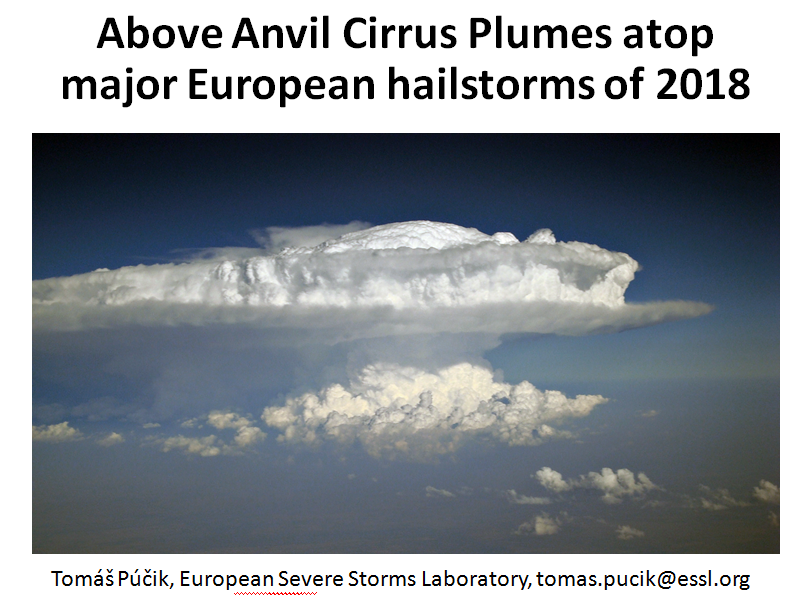
Tomas Pucik investigates the relation between AACP and hail occurrence.
Length: 23 minutes.
Above anvil cirrus plumes (AACPs) have been established in the scientific literature since 1980s. Recent improvements in the temporal and spatial resolution of the satellite data brought back attention to their potential use as an indicator of severity of convective storms. In 2018, we have identified 26 days, where damaging hail reaching at least 5 cm, causing significant economic or societal impact was reported to the European Severe Weather Database. For the selected hailstorm days, where rapid-scan imagery with 5-minute temporal resolution was available, we identified 29 very large (>= 5 cm) hail producing storms. 25 of these hailstorms did show an AACP, but only 12 of these plume producing storms could be clearly identified using the visible imagery. The range of lead time of the AACP appearance to the first hail report was very large and in about half of the cases, the plume occurred only during or after the time of the first large hail report. Due to the limited number of cases, the main purpose of the presentation is, rather than drawing conclusions, to open a discussion on the operational usability of AACPs in warnings for convective storms.