Identify and interpret fields and derived products
This mini-module is part of a series of MTG mini modules produced by EUMETSAT/EUMeTrain with the aim of providing quick and useful learning experience about the new satellite products.
In this exercise you will learn how to use LI data together with ground based measurements.
Enter the mini-module.
This mini-module is part of a series of MTG mini modules produced by EUMETSAT/EUMeTrain with the aim of providing quick and useful learning experience about the new satellite products.
In this exercise you will learn about features in LI data as well as some limitations.
Enter the mini-module.
Pieter Gröenemeijer talks about using the IRS data in the context of convection forecasting.
Go to lecture slides
Zsofia Kocsis shows a wide range of possible visualizations using IRS Level-2 (L2) test data.
The Infrared Sounder (IRS) onboard the MTG-S1 is the first geostationary sounding instrument to perform measurements over Europe with a temporal resolution of 30 minutes. EUMETSAT will provide temperature and water vapour profiles, together with instability indices derived from these measurements, thereby offering complementary information to Numerical Weather Prediction (NWP) model outputs and radiosonde observations for nowcasting applications. In this talk we will show different visualization of IRS Level-2 (L2) test data.
Suzana Panezic talks about using the Okamoto all-sky method in the regional numerical weather prediction model AROME using IASI radiances as proxy.
The InfraRed Sounder (IRS) on MTG-S1 will provide radiance measurements every 30 minutes across 1960 spectral channels, offering new opportunities to improve high-resolution weather forecasts. To fully exploit these data for operational use, assimilation methods are extended beyond clear-sky conditions to include observations affected by clouds. The Okamoto all-sky method is tested in the regional numerical weather prediction model AROME, employing IASI radiances as a proxy until IRS data are available.
Jun Li shows applications of GIIRS onboard the Fengyun satellite in National Satellite Meteorological Center.
Progress has been made on the applications of high-temporal-resolution GIIRS observations. These include but are not limited to deriving three-dimensional (3D) wind fields for nowcasting and NWP assimilation, trending atmospheric instability for warning in preconvective environments, and monitoring diurnal variation of atmospheric composition. This presentation provides a summary on the current applications of GIIRS, discusses the data processing challenges, and provides perspectives on future development.
Xavier Calbet talks about IRS and it's uses, specifically from NWC SAF side.
The MTG-S/IRS will be an infrared hyperspectral sounder in geostationary orbit, providing high spectral resolution radiances with a refresh rate of 30 minutes over the LAC-4 region (approximately the northern quarter of the IRS disk) and three consecutive slots every several hours over the rest of the LAC regions. The spatial resolution will be of 4 km at nadir. The MTG-S/IRS instrument will have close to 2000 channels in the thermal infrared which will allow the retrieval of temperature and water vapour profiles of the atmosphere at an unprecedented vertical resolution from geostationary orbit. The accuracy of the temperature and water vapour retrievals obtained from infrared sounders varies depending on the altitude, scene cloudiness and actual temperature and water vapour profile. The best accuracy and vertical resolution is typically obtained in the mid-troposphere, while the worst one is in the lower layers of the troposphere. Furthermore, retrievals show a good accuracy even over cloudy scenes reaching up to 80% cloud fraction. On average, the typical accuracy of infrared hyperspectral retrievals is approximately of 1 K in 1 km layers for temperature and 15% in 2 km layers for humidity.
Go to lecture slides
Stefan Stapelberg introduces Level 2 products from EUMETSAT's IRS intstrument.
The Infrared Sounder (IRS) aboard Europe’s new meteorological satellite offers highresolution, frequent atmospheric observations to enhance weather forecasting. Using EUMETSAT’s piecewise linear regression method, it retrieves detailed temperature, humidity, and ozone profiles with uncertainty estimates. These data, combined with cloud information and Instability indices, are expected to improve the performance of numerical weather prediction (NWP) models, particularly in the context of severe storm forecasting.
Go to lecture slides
Stephan Bojinski introduces the MTG-S and the instruments onboard.
An overview of Meteosat Third Generation (MTG) and the InfraRed Sounding mission is provided. The MTG-S satellite was launched on 1 July 2025 with an InfraRed Sounder (IRS) on board, passively measuring upwelling radiance in 1953 channels from geostationary orbit, every 30 min over Europe, and less frequently over other areas of the Earth disc. Valuable retrievals of humidity and temperature are expected with vertical resolution of 1-2km and spatial resolution of ~6-7km over Europe, complementing model-derived fields or radiosonde profiles. IRS is also sensitive to atmospheric trace gases such as NH3, SO2 and CO. Since this capability is a first-ever for EUMETSAT and its users, significant user training is required to visualise and interpret the data directly, e.g., in nowcasting applications. Strong impact on improving weather forecasting skill is expected by assimilating IRS radiances in NWP models, similar to data from its IASI sister missions in polar orbit. EUMETSAT informs its member states regularly informed about the status of IRS testing and release of early data via its MTG User Preparation user group and the Core NWP user group.
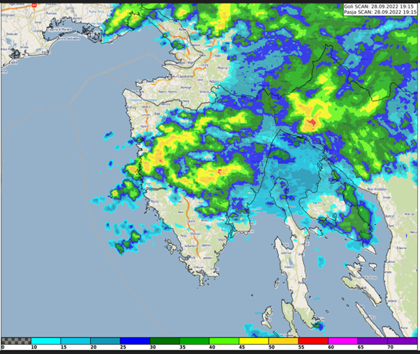
Case study about the extreme precipitation event in Rijeka, Croatia on 28 September 2022. The study focuses on the special case of convective development that caused the severe event.
This study accompanies the simulator.
Xavier Calbet goes over NWC SAF products available as well as some future planned ones. He also goes over the GEO-S software.
Go to lecture slides
Roberto Nicoletta talks about the H SAF P-IN-FCI (H40) instantaneous precipitation and P-AC-FCI (H42) accumulated precipitation products while Semih Kuter discusses the H SAF H43 Snow Cover Product.
This talk introduces the new H SAF P-IN-FCI (H40) instantaneous precipitation and P-AC-FCI (H42) accumulated precipitation products. They are an evolution of the H60 and H61 MSG products, having a significant increment in resolution and time frequency. They are put into evidence via some examples in the European region. Some details are shown to put show the 3-times enhancements in computing performances. How to download the new products through the new website interface is also introduced. EUMETSAT H SAF H43 daily snow cover product provides 2 km resolution binary snow maps derived from MTG-FCI observations. We outline key technical features of H43, demonstrate how to access and download the product via the EUMETSAT Data Services, and present initial validation results from the 2024–2025 winter season using MODIS reference data. Case studies from the European Alps and the Russia/Kazakhstan region illustrate performance across diverse landscapes.


