
Identify and interpret atmospheric phenomena
Case study on the abundant rainfall on 23 September 2008 in Valencia and Alicante.
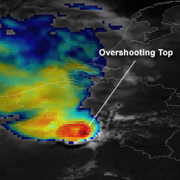
On 23 September 2008 an amazing amount 326 mm in three hours was recorded in Sueca in the Province of Valancia. The convective events leading up to this event are discussed in this small case study by Ramon Vazquez. The satellite images as well as the radar and data from the ground are presented and discussed.
On 7th October 2008 a cold front crossed northwestern part of the Iberian Peninsula, producing large amounts of precipitation and causing disruption of same activities in the affected areas.
In northwestern Portugal, a maximum of 41 mm in 6 hours was obtained in an automatic weather station (AWS) in a mountain area and a maximum of 20 mm in 1 hour in a coastal area, both reaching the orange warning lower threshold for meteoalarm (40mm in 6 hours and 20mm in 1 hour, respectively). The Portuguese meteorological service (IM) issued a yellow warning with 24 hours advance, and the orange warning has been issued 7 hours before the beginning of the period of heaviest precipitation.
The Winter Storm Klaus occured from 23 to 24 January and has been one of those rare cyclones which leaved a serious path of damage, especially in northern Spain and southern France.
Reaching explosive development rates as high as 34 mb in 24 hours, and registered maximum surface wind gusts of the order of 200 km/h. Klaus cyclone, as a system with a clear surface pressure signal, approximately started on day 23 about 00 UTC, in the middle of the Atlantic, at position shown below, with a minimum MSLP value of 1000 mb, according to ECMWF / HIRLAM analysis. The track of the cyclone was purely zonal and its speed was markedly high, reaching values above 100 km/h. A minimum surface pressure of about 964 mb at cyclone center took place on day 24 at about 00 UTC, more or less maintained for several hours during the warm seclusion phase of the system.

On 25th April 2009, a possible but unusual pattern called von Karman vortex developed to the Lee of Pico-island on the Azores.
On 25th April 2009, a possible but unusual pattern called von Karman vortex developed to the lee of Pico island. Very common in Madeira or Canary islands, this feature is not so common in the Azores Islands mainly due to their location in Atlantic Ocean. Note that MSG Infra-red 10.8 and visible 0.6 channels on usual 3km sub-satellite pixel resolution can depict the pattern reasonably well in comparison to NOAA 1km resolution.
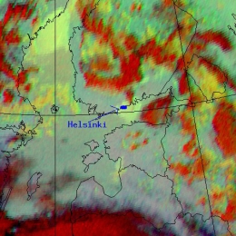
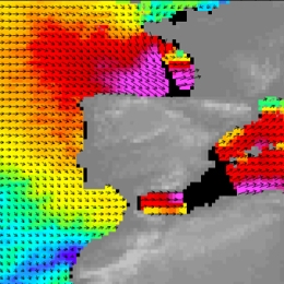
On 21st May 2009 a dense advection fog coming from the Gulf of Finland caused low visibilities across the region around Helsinki.
On 21st May 2009 a dense advection fog coming from the Gulf of Finland caused low visibilities across the region around Helsinki. The fog started to move inland from the Gulf around 1700 UTC and persisted until next morning on land areas while coastal water areas cleared during daytime.
These kind of fog situations typically occur in the Southern coast of Finland in April-May when the sea temperature is still cold and warm humid air is advected over the water from Central Europe or the Baltic area (and in the autumn months in reverse fashion as the water is still warm and land cold). This case study is focused on comparing how a global model (ECMWF) and a local model (AROME) performed in forecasting this situation.
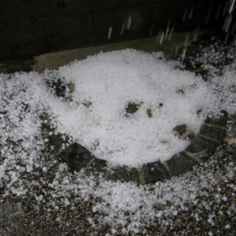
A severe convective outbreak with big hail and thunderstorms occurred over parts of western and central Europe on Monday, May 25th 2009.
A severe convective outbreak with big hail and thunderstorms occurred over parts of western and central Europe on Monday, May 25th 2009. Overnight, a strong squall-line developed that produced gusts in excess of 35 m s-1 across Northern France, Belgium and the Netherlands uprooting trees and causing considerable damage to property. In addition hail with diameter of 10 cm. was recorded.
The 23rd of July was marked by a fast transition of a cold front (about 80 km/h) from west to east which went along with severe thunderstorms and hail.
The 23rd of July was marked by a fast transition of a cold front (about 80 km/h) from west to east which went along with severe thunderstorms and hail. The catastrophic event caused enormous agricultural damage and the Austrian farmer alliance reported that about 60 000 hectare arable lands were devastated. The destruction mostly caused by hail was estimated to sum up 15 million euro. On this account people insist on investigations to find out what exactly caused the event. Besides on the meteorological perspective there is always great interest in improving forecast methods and forecast tools. In principle the following report provides a detailed analysis of the weather event. Basically the high potential of prefrontal thunderstorms was known, although there were diverse estimations about its development. It was the change of the wind direction due to the interaction between the convergence line and the foehn that induced the following weather development. Contributing to the wiki case studies this report should lead to a better understanding of the atmospheric conditions that special day and introduce new now casting-products (GII and SAI).
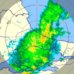
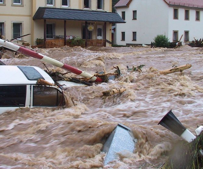
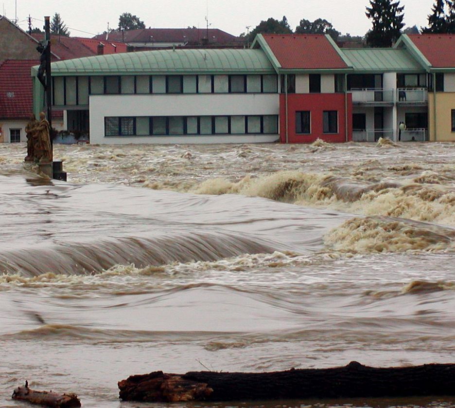
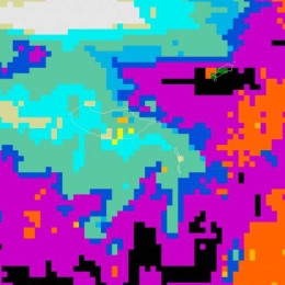
Torrential rainfall during the second week of September caused floods in the Istanbul area in Turkey.
Torrential rainfall during the second week of September caused floods in the Istanbul area in Turkey. As a result there were 32 casualties. Below we have pictured some satellite images with NWP. Striking is the Upper Level Low found over Central Turkey. This results in the advection of moist, unstable airmass from the Black Sea and topographic uplift which result in numerous rounds of showers and thunderstorms in the region. The cold temperatures found in the upper layers of the cold core low and its contrast to the warm surface causes the CBs to grow extreme in the vertical and producing lots of rain. Moreover, a weak wind field results in the slow storm movements.
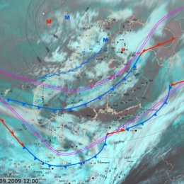
A particular strong wind event took place on 29 Sepetmber 2009. The event was characterized by a mesoscale convective line which was not reflected in any of the operational models.
A cold air outbreak took place in Finland on September 29, 2009. The most interesting part of this particular cold air outbreak was unexpectedly strong wind gusts. Operational models, except one, did not give a hint about strong wind gusts. The strongest observed gust was 30 m/s but fortunately no hazards or problems were reported from the sea areas around Finland. Newspapers reported some fallen trees and observations of roofs being blown off properties in southwest Finland. In this article, this particular event is evaluated and presented together with observational and operational model data.
Strong wind gusts also affected the standard measured 10 minute average wind speeds, so that the forecasted maximum was 12 m/s and the observed 20 m/s, which is close to official storm wind speed threshold in Finland. Operational forecaster on duty corrected forecasts quickly after observations showed higher than forecasted wind speeds.
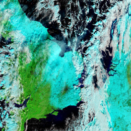
On 1st October 2009 almost 60 mm of precipitation have fallen in 6 hours on a mountain station in Madeira Island.
On 1st October 2009 almost 60 mm of precipitation have fallen in 6 hours (16-22 UTC) on a mountain station in Madeira Island (Areeiro, with a height of 1510m), which fitted the orange warning criteria (40 to 60 mm in 6 hours) used at the time at the Portuguese Met. Service. In a 24 hour period (12UTC on 1/10/2009 to 12 UTC on 2/10/2009) a total amount of 101 mm was recorded at the same weather station. An old large-scale low-pressure system was located over the Azores, to which a clear convective activity was related. These convective events were taking place to the northwest of Madeira Island and no special signal could be detected in satellite imagery at a first look over the island. Therefore, this episode could be considered to be kind of silent for this mean of observation.
A cold air outbreak during the second half of December 2009 brought mayhem to Western Europe and Croatia.
A Cold Air Outbreak directed by a strong anticyclone near Greenland directed polar air towards Europe. With the still relative warm waters of the North Sea and the genesis of several small scale disturbances over Scandinavia and Germany the ingredients were in place for many centimeters of snow in the UK, Netherlands and Germany.
The largest impacts the snow brought were experienced from 16 to 20 December. The largest railway station in the Netherlands (Utrecht CS) was closed on 17 December due to snowfall leaving thousands of passengers stranded. During the morning rush hour of 18 December there was a record breaking 671 kilometers of traffic jam. In England the snowfall had also lead to chaos when motorists were stuck on the A21 during the evening and night of 17 to 18 December. The next night five international EUROSTAR trains were stuck in the tunnel under the English Channel leaving 2.000 passengers trapped for 16 hours.
From a meteorological point of view this cold air outbreak is interesting as many parts of Europe were affected and that there were different conceptual models responsible which can be distinguished using satellite and numerical weather data. All of these are described in detail in this case study.
A cyclone developed over Spain causes heavy snowfall in the Mediterranean and Central Europe.
Between 10 and 12 February 2010 a Mediterranean low caused extreme snowfall in Styria and Carinthia, the south of Austria. This case study describes the synoptic situation and the further weather development during that time period. The comparison of the expected with the actual precipitation should show the accuracy of the forecast. On the basis of this case, an overview of the difficulties of precipitation forecast, especially for snowfall, is given.