
Identify and interpret atmospheric phenomena
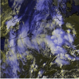
During the 9th and 10th July the Baltic States and Finland experienced heavy rain as a wave-cloud formed in moist and warm south-easterly air stream.
This study concentrates on two areas at the opposite sides of the low pressure area. The objective is to provide a detailed insight into the mechanisms that govern the formation of convection within a cold front (Finland) as well as prolonged rain within an occluded front (Lithuania).
In Lithuania the event was characterized by extreme rainfall (locally more than 250 mm in 3 days), leading to floods and severe damage. The south-westerly gusts on the 10th August caused uprooting of trees and further economic loss in excel of 45 million Euro. In Finland the most remarkable events were those connected with the passing of the cold front in the evening of August 9, associated with the intensive precipitation and lightning.
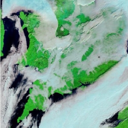
November 2005 severe snowfall had major effects in Western Europe. Snowfall caused an outage of power plants leaving people without heating and electricity.
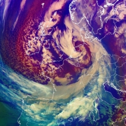
The case study describes the merging process of a comma-like cloud feature with a cold front cloud band. The term instant occlusion is used because the mature stage of the development shows a cloud spiral similar to that of a normal occlusion. But the meteorological processes are totally different from an occlusion process where advection of cold air lifts warm air. The process took place in an area of cold air without a warm front being present.
The subsequent snowfall caused an outage of power plants leaving people without heating and electricity for several days.
This study illustrates an interesting case of a cold front in cold air advection on which two waves are developing. The origin of these waves is different which is explained.
This case study follows a cold front propagating from the Atlantic towards eastern Europe at the leading side of a deepening upper level trough. Special attention is paid to two waves developing on the cold front. Both of them show similar phases of development, from the first appearance of a cloud bulge to the formation of a cloud spiral.
The whole process can be observed in several types of satellite images: IR, WV and Airmass RGB composite. In the IR images the formation of the both wave bulges, intensification of the frontal cloudiness and cloud spiral development can be followed. The WV images enable the detection of the jet and the intrusion of dry stratospheric air. In the Airmass RGB the different air mass types as well as the position of the jet stream can be detected.
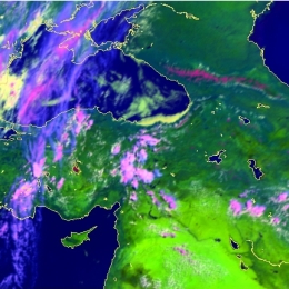
On 26th May the transition of a cold front trough Turkey was linked to serious convective developments. According to several reports the weather event was associated with hail.
The case study describes s series of convective developments which took place in front of a cold front as well as within the transition of that cold front. On 25th May first convective development were noticed over Romania at the leading edge of the front. Within the next few hours the convective developments started ahead of the front and were induced by orography.
During the night the convection was linked to the further movement of the cold front. The explosive convective development over Turkey on 26th May is nicely depicted in the set of radar-image and satellite images.
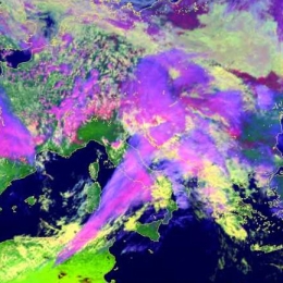
On 27 July 2006 such short-living-convective cells developed over Germany. These convective events marked the end of a long lasting heat period which characterized July 2006.
The case study describes the development of severe convection over Germany on 27 July 2006, which took place in the forefront of a cold front and an upper air trough. With the troughs approach the potential unstable warm and moist air over Central Europe was lifted. Supported by solar isolation, single cells and multi cells as well as super cells developed over eastern France and Germany, finally forming a north-south oriented squall line. Heavy precipitation of up to 30 mm/h and gusts of up to Beaufort 10 were registered.
A five day period of dense fog was overcasting London Heathrow during Christmas 2006 severely disrupting air traffic.
This case study presents the synoptic analysis of an event that took place from the 18th to 23th December over the UK. During this period dense fog was covering many places in the UK causing extremely bad conditions for aviation. For a busy international airport like Heathrow the cancellation of hundreds of flights just at the peak travel season (a few days before Christmas) meant chaos and significant economic loss. Changes in travel plans affected at least tens of thousands of passengers.
Fog itself is a common event on the British Isles at this time of the year. However, the duration of the episode justifies a closer look at the event. In addition, the visibility within the fog was at times very low, and this heavily affected the air-traffic even at airports having the most advanced instrumentation for low-visibility flight operations.
This study concentrates only on the area in the southeastern UK, but basically similar synoptic conditions with reduced visibility at times prevailed also on the European continent during this episode. What makes this case study differ from many other case studies is the absence or small influence of atmospheric fronts or dynamic forcing (such as PVA or PV anomalies).
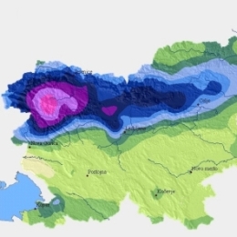
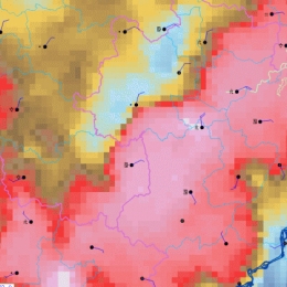
On 18 September 2007 Slovenia received 303 mm of rain in shy 24 hours. The result were flash floods and huge material damage.
This case-study presents the analysis of catastrophic flash floods in Slovenia that occurred on 18 September 2007. The flooding caused five casualties and huge material damage, estimated to more than 150 million Euro.
NWP models forecasted precipitation amounts of up to 100 mm/24h. That was the reason that the forecaster issued a warning for the precipitation at a rate of more than 100 mm/day, but the real values were much higher.
Besides analyzing synoptic and mesoscale conditions, that caused the extreme amount of precipitation, the objective of this study is also to show how nowcasting material can help a forecaster to issue additional warnings.
The synoptic analysis shows that on the day of the catastrophic event the area of low pressure was situated over the Northern Europe. A cold front was approaching the Alps and over Slovenia a series of prefrontal convective developments took place. In many regions in Slovenia the precipitation values were extremely high (>100 mm/day) with the maximum precipitation of 304 mm/24h officially measured in Kneske Ravne.
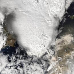
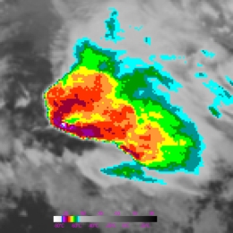
On 4th October 2007 a large Mesoscale Convective System hit the Balearic Island of Mallorca. Although the NWP model output did predict high convective activity, it did not expect it to take place near Mallorca.
On 4th October 2007 at 1530 UTC, a large Mesoscale Convective System (Mesoscale Convective System), passed over the Balearic Island of Mallorca. Associated to the Mesoscale Convective System an F2 tornado was reported. The Mesoscale Convective System was accompanied by severe wind gusts that spread the damage in numerous areas of the island. The longevity of the Mesoscale Convective System was quite remarkable (approx. 12 hours!), and in some stages of its life cycle, it showed a fast movement, taking a very short time, less than 1 hour, to cross Mallorca island.
A severe thunderstorm occurred at 5th of November 2007 in Cameli in the Western part of Turkey.
A severe thunderstorm occurred at 5th of November 2007 at Cameli town at the western part of Turkey. After the thunderstorms phone calls have been made by persons from the municipality of Cameli and with eye-witnesses. According to them, a small-scale tornado has been observed and three villages in the suburbs of Cameli have been affected.
Case Study on what happens when dry and cold air is transported over warmer seawater and moisture is picked up.
This a new example of the Conceptual Model, Convergence Lines over Seas and Lakes, is about a cloudstreet, developing into a well pronounced convergence line over the Sont, the narrow strait between Denmark and the southwest coast of Sweden. The evolution downstream over the west part of the Baltic Sea into the northwest part of Poland is studied as well. Coastal Convergence Lines, the other CM about developing convective clouds in cold air advection over warmer seawater, has a great similarity to convergence lines over sea and lakes. - Cloud streets, developed over sea, may intensify over land at a much larger distance from the coastline into an active squall line with embedded TS. An example of this side effect is presented as well.
From 29 February to 1 March 2008 storm Emma causes damage at several regions in Middle Europe. During only 12 hours a cold front and a succeeding convective line crossed Germany.
From 29 February to 1 March 2008, partly heavy thunderstorms with severe gusts and hail caused damages at several regions in Middle Europe. During only 12 hours a cold front and a succeeding convective line crossed Germany.
The storm Emma was a typical example of line convection with downbursts during a southeast movement of a storm field over the North Sea. The average velocity of the convective line was 110 km/h, sometimes 150 km/h. Behind the cold front dry atmospheric air (equivalent to high Potential Vorticity (PV)) could be recognised in the Airmass RGB.
Based on satellite imageries and numerical parameters the development of this event can be observed.
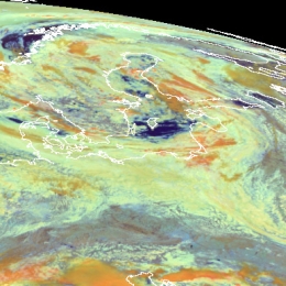
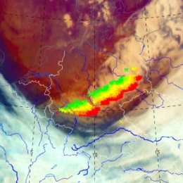
Case Study from China! On the 22nd of July 2008 was marked by a motion of a vortex with several convective cells along a frontal cloud band.
The 22nd of July 2008 was marked by a motion of a vortex with several convective cells along a frontal cloud band. At the leading edge of a frontal cloud system, lots of thunderstorms reported on the ground stations, and heavy rain, strong wind and lighten were observed. All of this weather events with caused enormous agriculture damage and economical lost. As the movement of vortex, several convective cells emerged and became a larger MCC because of merging each other, then the MCC was merged with a north MCC and brought severe weather in cloud area. So in this case, two different merging were analyzed in this case, first is the merger of cells and the second is a MCC merging with another one.