
Identify and interpret atmospheric phenomena
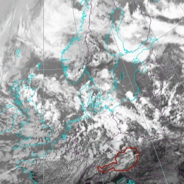
This case study discusses a Dark Stripe visible in water vapour imagery behind a Cold Front.
This case study will concern a Dark Stripe visible in water vapour imagery behind a Cold Front. This Dark Stripe indicates the presence of descending dry air, which can be of stratospheric origin. The stripe develops along the cyclonic side of the white water vapour band. Typical places of appearance of Dark Stripes are the rear of Cold Fronts and Occlusions, and the forward sides of Warm Fronts.

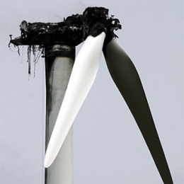
This case study deals with convective cells over Austria in a pre-frontal unstable airmass causing exceptionally intensive hail which is a rare phenomenon in this region.
This case study deals with convective cells over Austria in a pre-frontal unstable airmass causing exceptionally intensive hail and a tornado in Vienna which is a rare phenomenon in this region.

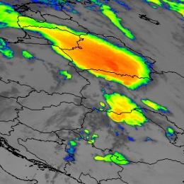
This catastrophic case describes the development of a Mesoscale Convective System starting in the Mid-Adriatic Sea and moving towards Bosnia and Herzegovina.
This catastrophic case describes the development of a Mesoscale Convective System starting in the Mid-Adriatic Sea and moving towards Bosnia and Herzegovina and then further NE. Heavy precipitation and flash flooding occurred in some Dalmatian towns, with severe hail inland.
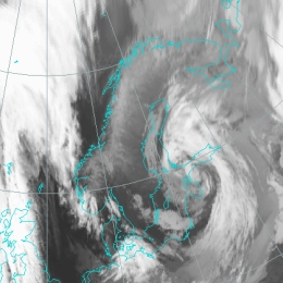
The Cyclonic development of a Genoa low with associated with strong Bora winds is studied. During the development process the system also interacts with a cyclone over France.
The Mediterranean Sea favours the development of weak low-pressure systems. In many cases the development begins in or near the Genoa Bay in the mid Mediterranean. Cyclones then move either towards south-east, along the southern coast of Italy and end up in the eastern Mediterranean, or towards north-east, into the Adriatic, where in many cases they get stronger or trigger secondary cyclogenesis. However, once the cyclones are formed, they often produce periods of rainy weather. In this case the development started in the Mid Mediterranean and the cyclone moved north-east, into the Adriatic and was linked to high precipitation and strong bora winds.
This case study addresses the unusual and rapid development of a small scale cold air feature into a synoptic scale frontal system.
A cyclogenesis is a rather complex process leading to an occlusion stage of a frontal system. There are at least two main theories: the classical occlusion process according to the polar front theory and the rapid cyclogenesis being a result of several processes where stratospheric and tropospheric features are acting together.
This case shows a very intensive development from a small scale comma to a synoptic scale cloud spiral. What makes this case so special is the fact that the cloud configurations are deviating from the usual development process of an occlusion spiral. Moreover the relevant NWP parameters demonstrate a situation with high potential for further developments.
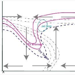
A frontal cloud is being studied which moves over central Europe and is enhanced due to jet intensifications in the left exit region.
This case study presents an interesting case of frontal intensification caused by jet crossing. The intensification of the frontal cloudiness takes place when a jet streak approaches the frontal cloud band.
In the satellite images elongated cloud fibres often indicate the location of jet axis, whereas the intensification area is well recognizable through much brighter grey-shades within the frontal cloud band. The areas of intensification are usually chracterized by more intensive precipitation, often in shower form, sometimes accompanied by lightning.
This case study is about an unusual development of a super cell over the North Sea that is embedded in a warm frontal Wave.
The case from 09 June 2004 is an example of an unusual development of a super cell because it developed over the relative cool water of the North Sea and a second phase of intensifying occurred about 4 hours after sunrise over Northern Germany. Precipitation amounts up to 20 mm and gusts up to Beaufort 10 were registered.
An intense frontal zone extended from England to Eastern Europe. The Southern parts of the North Sea and Northern Germany were affected by its warmer edge. Near the passage of the super cell the radio soundings exhibited a strong vertical wind shear, potential instability between 1 and 5 km height and a tropopause at about 12 km with -64C.
The warm front was super-imposed by warm air advection and positive vorticity advection at the right entrance of a jet streak. That induced the development of a warm front wave. Within the potential unstable air during the evening of the 8th June a super cell developed near Scotland and moved after a temporary decaying and splitting till the morning of the 9th June to Hamburg. The right cell reached its maximum intensity at around 07 UTC.
Under influence of frontogenesis the development of two waves within a frontal system is being studied.
This case study addresses the development of two waves within a frontal system over Central and East Europe. Waves are substructures of a cold front which indicates the initial stage of (secondary) cyclogenesis.
For this investigation two different waves will be analyzed using single satellite images as well as combined channel products. Moreover conceptual models which base on a certain selection of numerical parameters will be introduced. Based on the development of the two different wave systems, the quality of the background information (satellite imagery, NWP-field) can be assessed.
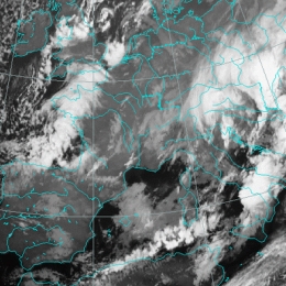
The case study describes two events of convection that occurred over Ukraine on 9th and 10th July 2004. Consequently heavy rain and rail were observed.
This case study addresses the formation of a mesoscale convective systems over the Ukraine on 9th and 10th July 2004 associated with heavy rainfall and hail. Cloud top temperatures of up to -70 degrees Celsius were observed. Moreover it should be noted that the Carpathian Mountains played a central role, since the mountain ridge triggered a set of cells.
In this study the development will be observed closely based on satellite imageries and the NWP-field. Since the vertical stratification is essential for the formation of convection, stability indices will be assessed as well.
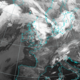
This case study is about a typical formation of a squall line moving from France towards Germany.
During the 18th August a frontal cloud pattern moved from Western France to Central Germany. From noon until the evening this cloud pattern transformed into a squall line due to cyclonic vorticity advection induced by a short wave trough. From the afternoon to the evening a mesoscale low with negative surface pressure tendencies developed east of the squall line. In combination with the increasing temperature contrast between the front and rear of the squall line, the velocity of the wind reached 100 km/h. Gusts of up to Beaufort 9 (flat areas) and 11 (mountainous regions) and precipitation of about 30 mm over Eastern France and and Western Germany were observed.
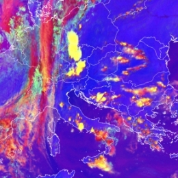
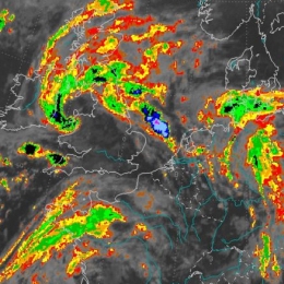
The case describes two convective events that happened end of May 2005 over Greece and Turkey and over Western Europe.
In the case study two types of convective development are observed and addressed. At the 30th of May a broad N-S oriented frontal zone is covering Western Europe. On the leading side of this front several convective cells emerge. A further index for frontal intensifications is the dry intrusion which can be detected in the WV imagery can be observed.
Apart from that several cells emerge in Greece and Turkey. The convective development in Greece and Turkey can be characterized as fair weather convection. In this case study it will be shown that both convective developments have similarities but also differences. Based on satellite imageries and derived numerical parameters these differences and similarities will be accentuated. However both weather events were associated with hail and lead to major damages in agriculture.
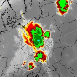
A classical example of prefrontal convergence occurred on 30 July 2005 as a long line of convective cells stretching over Central Europe developed.
On July 30th 2005 a prefrontal convergence line formed at the leading edge of a cold front. The long convergence line stretched from Italy over Austria into Poland and the Baltic States. Based on satellite imagery a sequence of thunderstorms could be observed. Moreover it should be noted that this form of prefrontal convergence is clearly linked to the diurnal cycle. As night sets in, most of the cells dissolve.
Since convection is a rather small scale phenomenon, it can be beneficial to address high resolution limited area models such as ALADIN-AUSTRIA. The comprehensive analysis of ALADIN-AUSTRIA revealed converging motions at 925 hPa and the divergence (e.g. outflow of air near the cloud top) at 700 hPa. In regard to the stability analysis the nowcasting tool GII (Global Instability Index) provided by EUMETSAT proved to be useful.