
Identify and interpret atmospheric phenomena
Frontal system across Europe with Wave development over South and South eastern Europe and a Front Intensification over Spain.
A frontal system located over Europe shows a wave development over south and south-eastern Europe and a front intensification over Spain between 12 and 13 November 1997. Special interest is focused on convective developments within the prefrontal area and the thickness ridge over the Balkan.
Arctic cold air outbreak over western Scandinavia and successive Rapid Cyclogenesis at the Lee side of the Scandinavian mountains.
Arctic cold air outbreak over western Scandinavia and successive Rapid Cyclogenesis at the Lee side of the Scandinavian mountains. The further development and severe weather events are investigated under the light of frontal connected jet streaks.
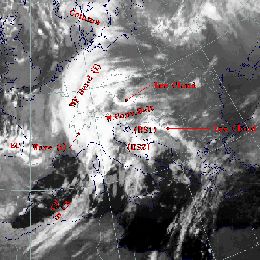
The chronologically changing behaviour of CMs during a cold air outbreak in the Mediterranean is the focus of interest.
Case study of various CMs over Eastern Europe and a WV Eye over the Mediterranean. Chronologically changing behaviour of CMs during a cold air outbreak in the Mediterranean is the focus of interest.
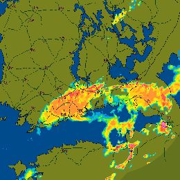
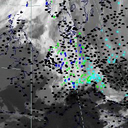
In this case study a Mesoscale Convective System associated to a convergence line is described.
In this case study a Mesoscale Convective System associated to a convergence line is described. The zone of strong convective activity initially extends from Estonia to Russia. During the life cycle it propagates to the North and finally reaches Southern Finland and causes heavy precipitation.
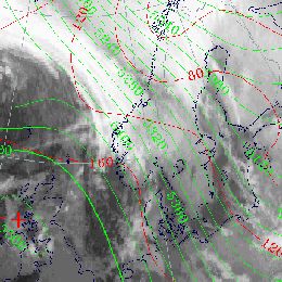
In this case study a low pressure systems with associated cloud bands over Eastern, Northeastern and Southern Europe is described.
Typical summer time distributions of low pressure systems with associated cloud bands over Eastern, Northeastern and Southern Europe (Black Sea Low). Development of frontal parameters and weather events relevant for Scandinavia are discussed in detail.
Christmas Storms development over Western and Central Europe due to successive Rapid Cyclogenesis development.
Christmas Storms over Western and Central Europe due to successive Rapid Cyclogenesis development.
Avalanche catastrophe in the Alpine Area. Extraordinary high amount of snow fall due to persisting barrage effect at the Alps.
Avalanche catastrophe in the Alpine Area. Extraordinary high amount of snowfall due to persisting barrage effect at the Alps.

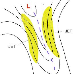
This case study discusses strong convective activity in a pre-frontal convergence line over northeastern Europe.
The purpose of this study is to investigate the circumstances which caused this particular pre-frontal convergence line to develop and to compare them with those typical for the conceptual model Non-orographic Convergence Line.

This case study a polar low affected north-western Europe between the 27th and 29th of January 2004.
In this case a Polar Low affected North-western Europe between the 27th and 29th of January 2004. The Polar Low moved along the Norwegian coast then southwards in a northerly flow and turned over the North Sea in the direction of the German Bight. Eventually the Polar Low made landfall over the border between the northern parts of The Netherlands and Germany.
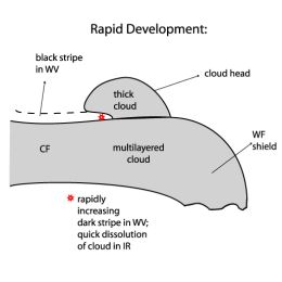
This case study discusses a front decay over central and northern Europe, the impact of CA and distinct sinking within a frontal cloud band.
Front Decay over Central and Northern Europe. The impact of CA and distinct sinking within a frontal cloud band is shown in detail.

Storm Janika over Greenland, the Northern Atlantic and Finland.
From 10th to 16th of November 2001 a series of intensive storms moved over the Northern Atlantic and passed through Scandinavia and Finland to the east. A few of the storms were remnants of hurricanes but the one storm that caused extensive damage, at least to Finland, was of a smaller scale. It was named "Janika".
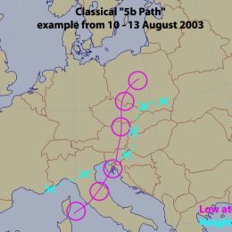
This catastrophic case describes two Mediterranean low pressure systems, propagating along a so-called 5b path.
In August 2002 two Mediterranean low pressure systems developed, taking a so-called 5b path. Such occurrences are rather unusual in summer as was the very rapid repetition rate of two events within about 8 days. The first event happened between 06 and 08 August, the second between 10 and 13 August.