
Identify and interpret fields and derived products

Presentation during the event week on Convection in June 2008.
Guy Kelman (Hebrew University of Jerusalem) explained the relationship between cloud top temperature and effective radius and emphasised the advantage this can have on the lead time and the possibility to nowcast areas with a high potential of severe convection. The session was followed by Wilfried Jacobs (DWD) on the Automatic weather and product monitoring (Automon).
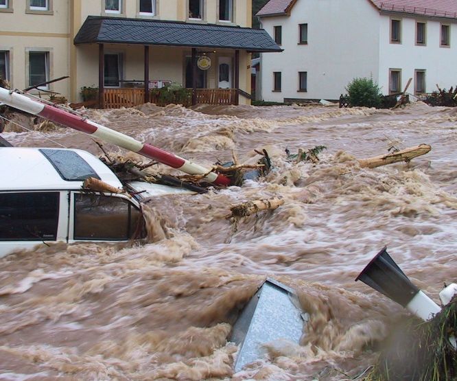
Case study on the abundant rainfall on 23 September 2008 in Valencia and Alicante.
On 23 September 2008 an amazing amount 326 mm in three hours was recorded in Sueca in the Province of Valancia. The convective events leading up to this event are discussed in this small case study by Ramon Vazquez. The satellite images as well as the radar and data from the ground are presented and discussed.
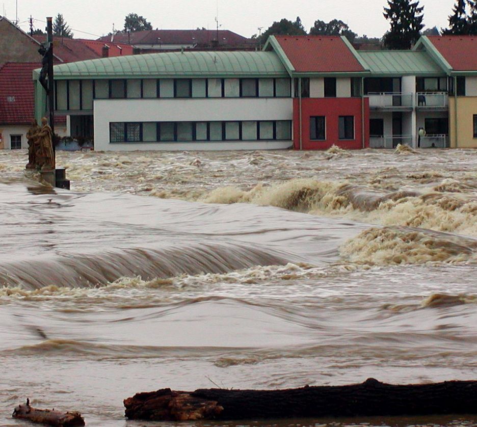
On 7th October 2008 a cold front crossed northwestern part of the Iberian Peninsula, producing large amounts of precipitation and causing disruption of same activities in the affected areas.
In northwestern Portugal, a maximum of 41 mm in 6 hours was obtained in an automatic weather station (AWS) in a mountain area and a maximum of 20 mm in 1 hour in a coastal area, both reaching the orange warning lower threshold for meteoalarm (40mm in 6 hours and 20mm in 1 hour, respectively). The Portuguese meteorological service (IM) issued a yellow warning with 24 hours advance, and the orange warning has been issued 7 hours before the beginning of the period of heaviest precipitation.
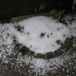
The 23rd of July was marked by a fast transition of a cold front (about 80 km/h) from west to east which went along with severe thunderstorms and hail.
The 23rd of July was marked by a fast transition of a cold front (about 80 km/h) from west to east which went along with severe thunderstorms and hail. The catastrophic event caused enormous agricultural damage and the Austrian farmer alliance reported that about 60 000 hectare arable lands were devastated. The destruction mostly caused by hail was estimated to sum up 15 million euro. On this account people insist on investigations to find out what exactly caused the event. Besides on the meteorological perspective there is always great interest in improving forecast methods and forecast tools. In principle the following report provides a detailed analysis of the weather event. Basically the high potential of prefrontal thunderstorms was known, although there were diverse estimations about its development. It was the change of the wind direction due to the interaction between the convergence line and the foehn that induced the following weather development. Contributing to the wiki case studies this report should lead to a better understanding of the atmospheric conditions that special day and introduce new now casting-products (GII and SAI).
On September 12th 2010 a major PV anomaly, in the rear of a cold front, moved over France and hit Germany and Switzerland in the late evening and also Austria during the night. On the front side of this anomaly convective cells developed and brought some rain showers and thunderstorms.
On September 12th 2010 a major PV anomaly, in the rear of a cold front, moved over France and hit Germany and Switzerland in the late evening and also Austria during the night. On the front side of this anomaly convective cells developed and brought some rain showers and thunderstorms. At first the ECMWF-model, especially the 00 UTC run from September 12th, was lacking performance shifted the PV maximum more westward. In this case study we analyse not only the synoptic situation, but also the model error. In the following we take a look at the MPEF (Meteosat Product Extraction Facility) Divergence product, how it works and whether it would have been helpful in this case as a nowcasting tool.
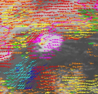
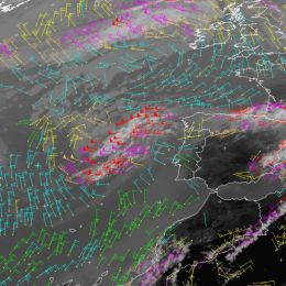
At 18 August 2011 a severe thunderstorm system developed over Belgium. This case study investigates the synoptic situation in which the windstorm developed using satellite, radar, NWP fields and lightning data.
On 18 August 2011 a severe thunderstorm system developed over Belgium. It initiated over France and then passed over Belgium, the Netherlands and Germany. The studied thunderstorm grew fast and was long-lived. It was extremely severe; particularly the downdraft was extremely strong. The most intense part of the windstorm hit the Pukkelpop festival organized close to the city of Hasselt. There were 60 thousand people at the festival, staying mainly at the camping site. The strong wind flattened tents, uprooted trees, brought down festival light towers and TV screens, and caused a stage to collapse. Five people were killed and 140 people injured in the storm, ten of them seriously. The aim of this case study is to describe the synoptic situation in which the windstorm was initiated and developed, and to describe its characteristics by means of satellite, radar and lightning data and numerical simulation.
In this module, we will introduce the concept of Total Precipitable Water (TPW) and show how satellite-based products help in estimating the amount of water vapour in the atmosphere.
In this module, we will introduce the concept of "Total Precipitable Water" (TPW) and show how satellite-based products help in estimating the amount of water vapour in the atmosphere. The module starts with an overview on measuring principles and algorithms on how to retrieve the water vapour content of the atmosphere. In the second chapter, you will learn more about the different TPW products from geostationary and polar orbiting satellites. Finally you will see some practical applications of TPW products in nowcasting precipitation events.
Go to the Product Tutorial ...
The purpose of this tutorial is to help the reader understand and use the SEVIRI Physical Retrieval (SPhR) product of the EUMETSAT Nowcasting SAF.
The purpose of this tutorial is to help the reader understand and use the SEVIRI Physical Retrieval (SPhR) product. SPhR's purpose is to provide information on convective environmental parameters, particularly on moisture content and atmospheric instability. These parameters are crucial in studying the potential for deep convection, and in predicting the development of convective clouds. Moisture, instability and a lifting (trigger) mechanism are needed for the formation of deep convection.
The purpose of this tutorial is to give an introduction into the topic wind measurement from satellite.
Knowledge of atmospheric motion is essential for many applications. Information on high-level atmospheric winds is of great importance for forecast models as the current state of the atmosphere has to be specified before the future state can be predicted. Winds in the upper levels can be observed using radiosondes or aircraft measurements, but those observations are limited in time and space. As satellites provide worldwide and continuous data, they are the ideal data source for regular upper atmospheric wind information.
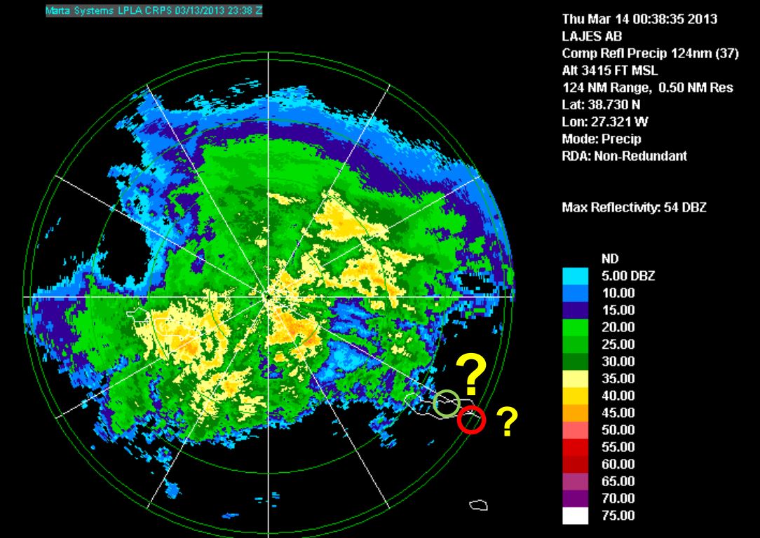
Diamantino Henriques gives a weather briefing for the Azores and looks back to the heavy rain event on 13th and 14th March 2013.
Length: 30 min
Author: Diamantino Henriques
Diamantino Henriques, received his degree in Atmospheric Physics at the University of Aveiro (1986) and his MS in Meteorology from the University of Lisboa (1996). From 1987 to 2003 he worked in Lisbon as meteorologist on atmospheric ozone and UV radiation issues. He has represented Portugal on several international meetings related with atmospheric composition and has participated in several projects and programs related with atmospheric ozone (GAW), atmospheric pollutants transport (EMEP) and UV radiation (EDUCE). In 2003 he moves to the Azores and worked at Ponta Delgada Airport as a senior meteorologist and forecaster. Later in 2008 he was nominated Head of the Regional Delegation of the Portuguese Institute of Meteorology (IM) in the Azores. Currently, he is the Head of the Azores Regional Delegation of the Portuguese Sea and Atmosphere Institute (IPMA, former IM) that includes the weather forecast service for the Azores.
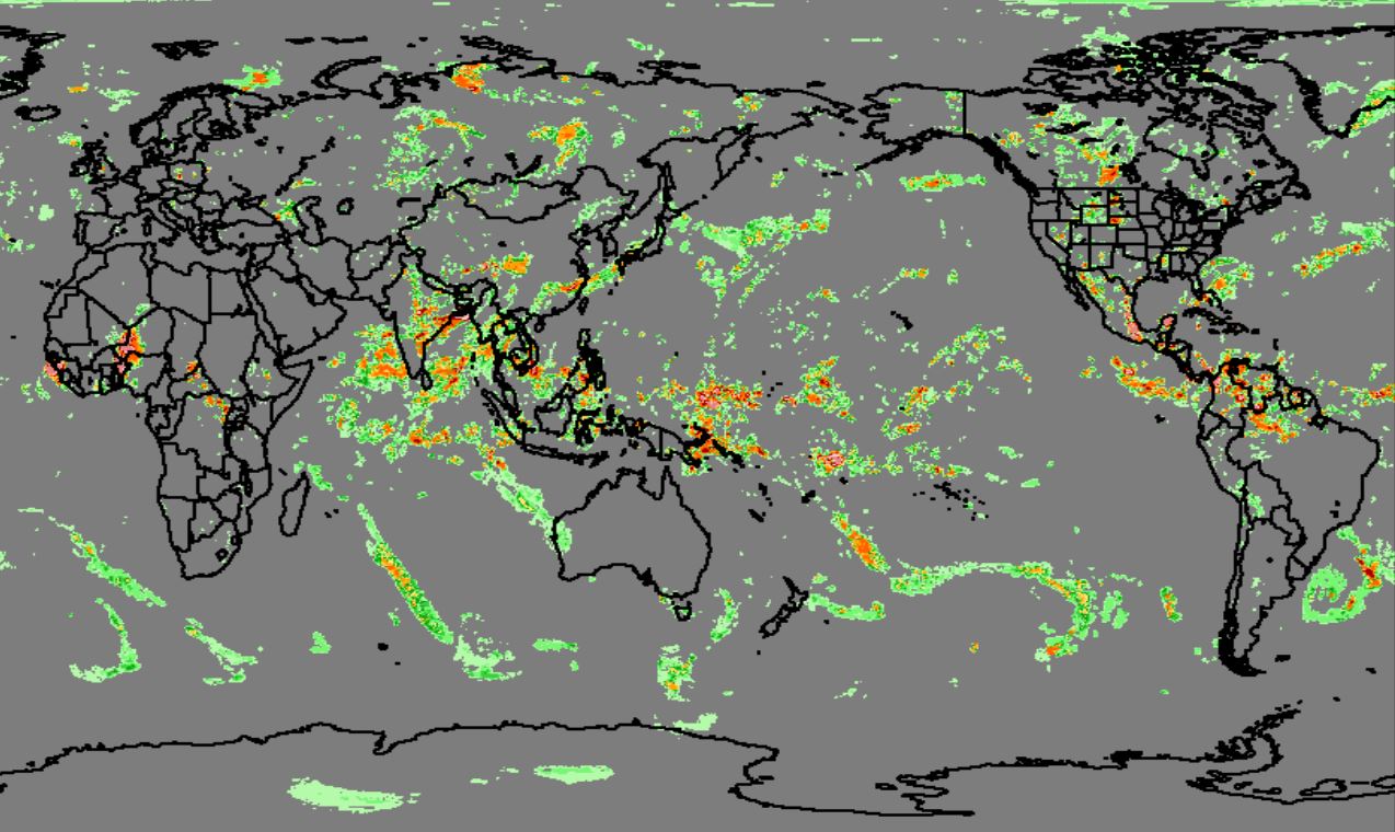
Robert Joyce presents the second generation CMORPH product.
Length: 30 min
Author: Robert Joyce (NOAA)
As reported at the AMS annual meeting of 2015, a prototype system was developed for the second generation CMORPH to produce global analyses of 30-min precipitation on a 0.05° lat/lon grid over the entire globe from pole to pole through integration of information from satellite observations as well as numerical model simulations. The second generation CMORPH is built upon the Kalman Filter based CMORPH algorithm of Joyce and Xie (2011). Inputs to the system include rainfall and snowfall rate retrievals from passive microwave (PMW) measurements aboard all available low earth orbit (LEO) satellites, precipitation estimates derived from infrared (IR) observations of geostationary (GEO) as well as LEO platforms, and precipitation simulations from numerical global models. Key to the success of the 2nd generation CMORPH, among a couple of other elements, are the development of a LEO-IR based precipitation estimation to fill in the polar gaps and objectively analyzed cloud motion vectors to capture the cloud movements of various spatial scales over the entire globe. In this presentation, we report our recent work on the LEO-IR based precipitation estimation.
The prototype algorithm for the LEO IR precipitation estimation is refined to achieve improved quantitative accuracy and consistency with PMW retrievals. AVHRR IR TBB data from all LEO satellites are first remapped to a 0.05olat/lon grid over the entire globe and in a 30-min interval. Temporally and spatially co-located data pairs of the LEO TBB and inter-calibrated combined satellite PMW retrievals (MWCOMB) over the tropics and mid latitudes and CloudSat radar precipitation over high latitudes and polar regions are then collected to construct tables. Precipitation at a grid box is derived from the TBB through matching the PDF tables for the TBB and the MWCOMB/Cloudsat-precipitation. This procedure is implemented for different season, latitude band and underlying surface types to account for the variations in the cloud – precipitation relationship.
Quantitative experiments are conducted to optimize the LEO IR based precipitation estimation technique using MWCOMB/CloudSat.
Tristan L'Ecuyer presents satellite precipitation products based on radar technology.
Length: 30 min
Author: Tristan L´Ecuyer (University of Wisconsin-Madison)
Radars provide the most direct means of remotely measuring precipitation over large areas. The value of ground-based radars for indicating the location and intensity of rainfall was recognized shortly after the first surveillance radars were developed during World War II. Since then radar networks have been widely used to estimate precipitation accumulations, track storms, and provide valuable information to the public. However, vast areas of the Earth including oceanic, mountainous, and densely forested regions are largely inaccessible to ground-based instruments. As a result, much of our knowledge of precipitation in such areas derives from passive satellite measurements that can suffer from uncertainties owing to the indirect relationship between radiation measured at the satellite and rainfall at the surface. Satellite precipitation radars offer some of the benefits of their ground-based counterparts with the enhanced coverage afforded by orbiting the Earth. To date three such radars have been launched providing a new perspective of global precipitation from tropical rainfall to polar snows that complements the longer-term record provided by passive instruments. This lecture will describe the physical principles used to relate the reflectivities measured by these radars to precipitation intensity. We will examine the main features of the associated precipitation retrieval algorithms and some of the important factors that need to be considered will be highlighted through illustrative examples. We will conclude by contrasting the strengths and limitations of satellite radars against passive satellite sensors and ground-based radar systems.