
Identify and interpret fields and derived products
Presentation during the event week on Warning in October 2010.
Rainfall warnings have not been issued in Finland until 2009. In the earlier years heavy rain forecasting was considered to be a too challenging task. However, growing demand for warnings together with some advancements in forecasts have changed this. Nowadays FMI provides warnings for the general public, authorities and commercial clients. In this presentation FMI's heavy rain warnings are presented and discussed.
Presentation during the event week on Warning in October 2010.
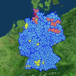
Instead of fixed warning thresholds, ZAMG has introduced the principle of annualities for their warning parameters. This decision was also chosen because most European NMSs also do it like this way. A yellow warning means that a situation exists only 17 times per year, which is an event which should be cautiously observed, but for which experience exists; an orange warning describes a situation which is only 3 times per year observed, therefore increased alert is necessary; a red warnng is an event which appears only 1 to 3 times per years and is therefore an extreme event.
Presentation during the event week on Warning in October 2010.
Presentation developed by Guido Wolz, Rolf Ullrich, Bernhard Reichert and Wilfried Jacobs on the warning system at Deutscher Wetterdienst (DWD). The issue of weather warnings by DWD is a task according to law. Especially if weather situations can cause danger for persons and material.
The warning management is split in 3 parts: Early warning in which information as possibility (very likely, likely possible) of significant weather situations on a national scale (250-700 km) from 2 day to one week. Pre-warnings in which severe weather situations on a regional scale (50-250 km) from 1 to 2 days is expected. Finally, rural district warnings where concrete warnings are issued for one or more rural district with a preliminary lead time; if necessary with differentiation of height levels.
Presentation during the event week on Fog and Low Clouds in January 2009.
Herve Le Gleau (Meteo-France) will talk about the SAFNWC/MSG cloud type/height parameters. The algorithms, validation results, limitations and recent improvements (to be available to users in March 2009) will be presented and illustrated with low cloud/fog situations. An automatic use at Meteo-France of the NWCSAF/MSG cloud type for fog risk mapping will also be shown.
Presentation during the event week on Convection in June 2009.
In 2008 the Slovakian Meteorological Institute (SHMU) has successfully implemented GII in their forecasting room. The difference being that the ALADIN model is used which provides a higher resolution being helpful to the forecasters. Jan Kanak will present this concept and show some examples.
This talk will be followed by Teodoro La Rocca from Italy on the use of air masses classification in the identification of synoptic conditions favourable to the development of convective phenomena.
Presentation during the event week on Convection in June 2009.
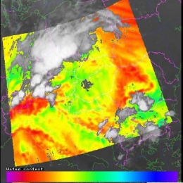
Christo Georgiev from the Bulgarian Meteorological Service will talk about Deep moisture convection (DMC) with the thermodynamic context as seen in WV channels 6.2 and 7.3 of Meteosat Second Generation.
The talk will be followed by a practical session done by Estelle deConing from the South African Weather Service who will talk about the successful implementation of GII (Global Instability Index) and the operational use of it, at their weather service using their model as first guess.
Presentation during the event week on Convection in June 2009.
Presentation from DLR where Tobias Zinner and Caroline Forster will present the topic Synthetic satellite images based on COSMO. The talk will be divided in two halves. First, RTTOV implementation into COSMO is explained and Tobias will show applications of synthetic satellite data in the DLR remote sensing and weather forecast groups. Afterwards, Caroline Forster would present her work on the combination of satellite based nowcasting and COSMO forecast via synthetic satellite data.
The second part of this session will be done by Mateja Irsic Zibert from the Environmental Agency of the Republic of Slovenia. The title of her presentation will be on convection in Slovenia: Remote sensing data on selected examples.
Presentation during the event week on Convection in June 2009.
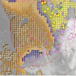
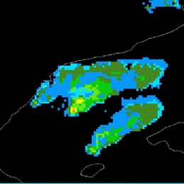
The recent version of NWCSAF has seen a whole list of updates and improvements of the products. One of this is the Convective Rainfall Rate (CRR). This product was developed by AEMET in Spain. Cecilia Marcos will explain the products, the algorithms behind it and show case studies.
The presentation will be followed by Ramon Vazquez who acts as a trainer to AEMET. He will talk about operational nowcasting and monitoring of convection at AEMET.
Presentation during the event week on Convection in June 2008.
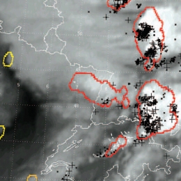
Kris Bedka (University of Wisconsin) and John Mecikalski (University of Alabama) gave a presentation on the Convective Initiation (CI) method. The CI product identifies cumulus-type clouds within an MSG image and uses the temporal evolution of the related MSG observations to identify rapidly growing cumulus as likely candidates to evolve into potentially strong convective storms up to one hour in the future.
This session was continued by the Portuguese Met Service (IM). Besides the diagnostic tools from Numerical Weather Prediction models currently in use, satellite and radar products were addressed, including automatic warnings, e.g. for hail.
Presentation during the event week on Convection in June 2008.
Marianne Koenig (EUMETSAT) demonstrated the GII product. For the forecaster this was a very interesting talk as it showed the advantages the use of GII has to a model. Case studies saw the potential the GII product has and which added value(!) the GII has to a normal model run.
The lecture was followed by Maurice Schmeitz from KNMI on the development and verification of a new model output statistics (MOS) system, which is intended to help the forecasters to decide whether a weather alarm for severe thunderstorms should be issued.
Presentation during the event week on Convection in June 2008.
Marianne Koenig (EUMETSAT) demonstrated the GII product. For the forecaster this was a very interesting talk as it showed the advantages the use of GII has to a model. Case studies saw the potential the GII product has and which added value(!) the GII has to a normal model run. The session was followed by Jenni Teittinen from the Finnish Meteorological Institute who talked about warnings and the assessment of warnings in Finland.
Presentation during the event week on Convection in June 2008.
Guy Kelman (Hebrew University of Jerusalem) also showed some more examples of nowcasting convection over the States. The session was followed by a very good presentation of Natasa Strelec Mahovic (DHMZ) who in depth presented what material and products the Forecaster have available in Croatia when they start their working day and the day turns out to be convective.