
Understand NWP outputs
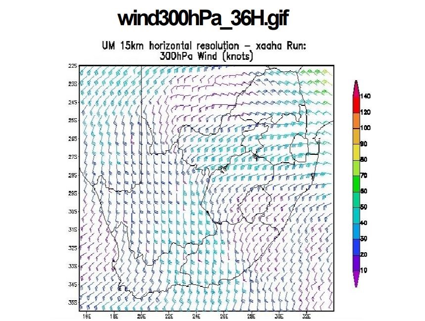
Lee-Ann Simpson and Jannie Stander from the South-African Weather Service started the first session of the WWW-Briefing. Lee-Ann gave a weather briefing for the South-African region and Jannie introduced the conceptual models of cold fronts and cut-off lows as they appear on the southern hemisphere.
Length: 50 min
Author: Lee-Ann Simpson, Jannie Stander
Lee-Ann Simpson is currently working as a meteorological trainer in the Regional Training Center (RTC) in Pretoria. She worked as an operational forecaster from 2003-2008, after which she started in the training department. She presently lectures to Post graduate forecasting students, focusing on specialized weather forecasting and satellite meteorology. Through the University of Pretoria, she lectures satellite meteorology and Tropical meteorology to honours students. Her interests lie in short term forecasting, severe weather and all satellite based interpretation of weather phenomena. She has a BSc (Hon) in Meteorology from the University of Pretoria and she is currently completing her MSc through the same institution.
Jannie Stander has worked as an operational weather forecaster from 1998 to 2005. Since 2006 Jannie has been working in the Regional Training Centre at Pretoria providing marine (2006-2008) and aviation forecaster training (2008-current). His main interests are aviation meteorology, synoptic meteorology and satellite interpretation and he is involved with several international working groups within these disciplines. He holds a BSc Hons degree in Meteorology at the University of Pretoria and is currently completing his MSc at the same University.
Mahmood Al-Khayari gives an overview of typical weather situations in the Sultanate of Oman.
Length: 30 min
Author: Mahmood Al-Khayari
Mahmood Al-Khayari graduated at Saint Louis University (Missouri State), USA, with BS in meteorology in 2003. He is also holding MS in an engineering field from Sultan Qaboos University. Mahmood Al-Khayari works at Oman Met Service since Feb 2004 until now as meteorologist specialized in forecasting. He has done different kinds of forecasting: General, Aviation and Marine. Also he worked as a lecturer during this period in many courses such as: Met Technician course, aviation courses for Royal Force courses, marine courses for Oman Royal Navy, and many others. Mahmood Al-Khayari was recently selected to take care of the chief's duties of Remote sensing and research section.
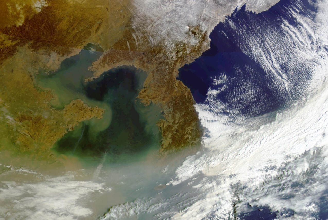
Ok Hee Kim holds the weather briefing for the South Korean region. Her topics are: Asian Dust, Typhoons and typical weather phenomena in East Asia.
Length: 50 min
Author: Ok Hee Kim
Ok Hee received her BSc in Astronomy at the Chungbuk National University at Chungchungbukdo the province of South Korea (1992), and MSc in Meteorology from the Seoul National University in Seoul South Korea (2004). She is preparing for the PhD. Her areas of interest include severe weather, lake-effect snow, Asian dust, fog and applications of satellite imagery to weather forecasting, particularly on the mesoscale. She worked at weather forecasting division as assistant for weather forecaster for 3 years from 1992 and satellite image analyst 3 years from 1996. She has been a research associate at NMSC (National Meteorological Satellite Center) KMA (Korea Meteorological Administration) since 2006. She is currently working as a meteorological satellite image trainer and analyzer of COMS (Communication Ocean Meteorological Satellite) image for KMA's weather forecaster in NMSC. Presently, she is trying to develop Conceptual Models which are applicated in East Asia after training SATREP in ZAMG.
Vesa Nietosvaara and Larisa Nikitina give a weather briefing for the European region, Larisa focusses on the preparations for the 2014 Olympic Games in Sochi.
Length: 55 min
Author: Vesa Nietosvaara, Larisa Nikitina
Vesa Nietosvaara has worked as an operational weather forecaster for twenty years in 1988-2008. Since 1998 Vesa has been working within several training projects and created learning resources for operational meteorologists. Particularly, he is interested in satellite image interpretation and conceptual models for weather diagnosis. Most of his career Vesa has done at the Finnish Meteorological Institute, but since 2012 he works as a Training Officer at EUMETSAT. He assists the EUMeTrain monthly weather briefing team and regularly participates or lead the European online weather briefings (ePort weather briefings).
Larisa (Lara) Nikitina has been working as aviation weather forecaster in Rostov aviation center (Rostov-on-Don, south Russia) since 1985 after training as a weather forecaster in Russian State Hydrometeorological University (RSHU). And since 2010 she became the weather forecaster for Sochi 2014 Winter Olympics. Her special interests are the satellite meteorology applications for nowcasting and distance learning.
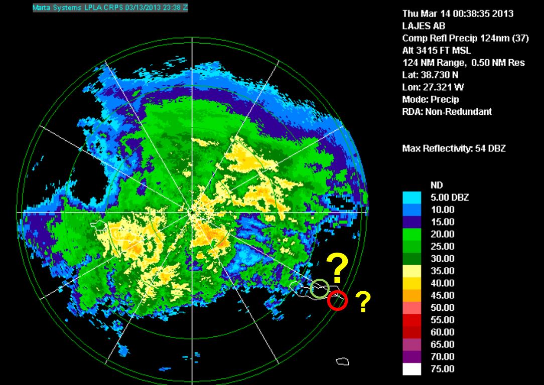
Diamantino Henriques gives a weather briefing for the Azores and looks back to the heavy rain event on 13th and 14th March 2013.
Length: 30 min
Author: Diamantino Henriques
Diamantino Henriques, received his degree in Atmospheric Physics at the University of Aveiro (1986) and his MS in Meteorology from the University of Lisboa (1996). From 1987 to 2003 he worked in Lisbon as meteorologist on atmospheric ozone and UV radiation issues. He has represented Portugal on several international meetings related with atmospheric composition and has participated in several projects and programs related with atmospheric ozone (GAW), atmospheric pollutants transport (EMEP) and UV radiation (EDUCE). In 2003 he moves to the Azores and worked at Ponta Delgada Airport as a senior meteorologist and forecaster. Later in 2008 he was nominated Head of the Regional Delegation of the Portuguese Institute of Meteorology (IM) in the Azores. Currently, he is the Head of the Azores Regional Delegation of the Portuguese Sea and Atmosphere Institute (IPMA, former IM) that includes the weather forecast service for the Azores.
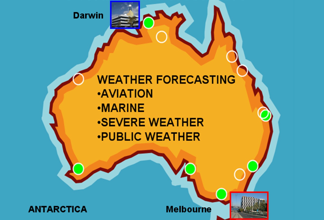
Bodo Zeschke gives a comprehensive overview of the technical facilities available at the Australian Bureau of Meteorology followed by a weather briefing and a short lecture on shallow cold fronts.
Length: 50 min
Author: Bodo Zeschke
Bodo Zeschke received his BS in Physics at the University of New South Wales and MS in Meteorology at Monash University (2001). From 2001 to 2009 he worked as a forecaster at the Darwin Regional Forecasting Centre. During this time Bodo developed an interest in fog and low cloud nowcasting and forecasting for northern Australian regions. Since 2009 he has been engaged as a Lecturer to Australian and International postgraduate students studying for the Diploma of Meteorology at the Bureau of Meteorology Training Centre. Bodo has lectured in Tropical Meteorology, Satellite Meteorology and Weather Discussion training. Duties also include presenting lectures on related topics at World Meteorology Organisation courses and at the Bureau's annual Advanced Forecaster Workshop. He is the point of contact for the Australian VLab Centre of Excellence. Present topic of interest includes the integration of the satellite multichannel RGB products generated from MODIS imagery into Bureau forecast and training resources. This in preparation for the effective use of RGB products generated by the future Himawari 8 satellite.

Phil Chadwick introduces his home country Canada and talks about the challenges a forecasters has to face in this large coutry. He puts most emphasis on satellite images and water vapour patterns.
Length: 50 min
Author: Phil Chadwick
Trained at Queen's University as a nuclear physicist, "Phil the Forecaster" has been a professional meteorologist since 1976. Officially retired in 2011 Phil still continues to advance his research efforts with COMET and the Meteorological Service of Canada (MSC). Satellite and radar meteorology are his forte. Much of this research has been published by COMET under the Satellite Palette banner. Phil has also completed original and extensive research on performance measurement. This large body of work resides in the Case Studies section of Northern Latitude Meteorology (NorLatMet/COMET). Aside from the above Phil has been painting en plein air forever - Philtheforecaster.blogspot.com - art and science are indeed similar endeavours. A sense of humour bundles all of this together and makes learning and teaching fun.
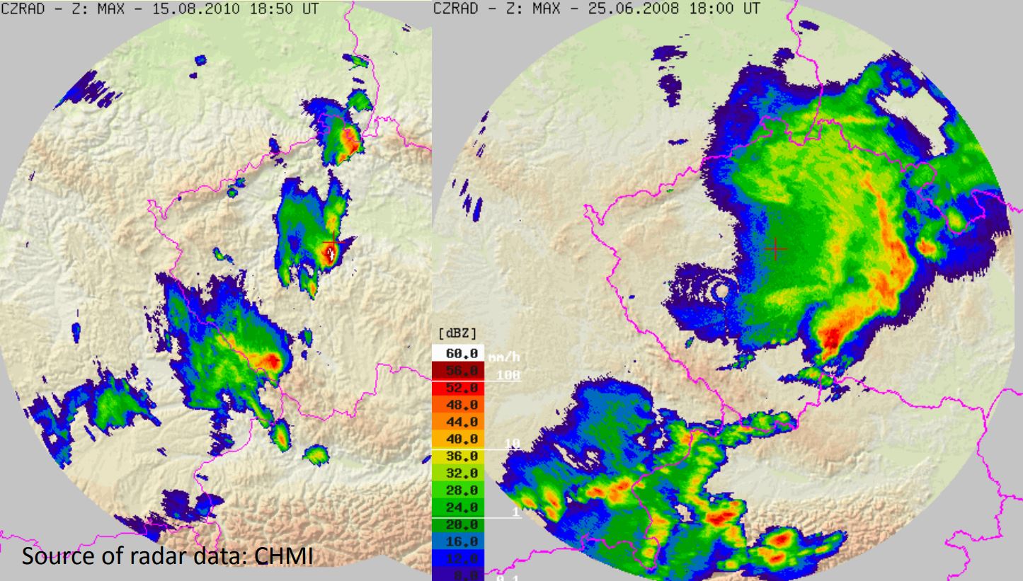
Izidor Pelajic gives a presentation on the evaluation of precipitation products from the NWC-SAF.
Length: 30 min
Author: Izidor Pelajić (DHMZ)
Croatian Adriatic coast is one of the rainiest areas in Europe. Large parts of the coast are not covered by the Croatian Radar network. The Croatian Weather Service (DHMZ) uses data from the NWC-SAF precipitation products to complement Radar data. Results from a validation campaign, using Radar and rain gauge data, will be shown in this presentation.
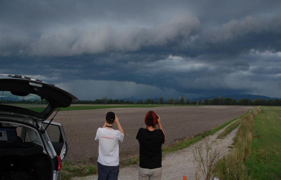
Christoph Gatzen gives an overview of cold-season derechos that occurred across Central Europe between 1997 and 2014.
Length: 30 min
Author: Christoph Gatzen (MeteoGroup)
The presentation gives an overview of cold-season derechos that occurred across Central Europe between 1997 and 2014. The environmental conditions leading to persistent, intense thunderstorms and associated long-track high wind events are analyzed using reanalysis data and proximity soundings. A focus is the development of deep moist convection in initially stable air masses due to synoptic-scale processes.
Tomas Pucik presents a study of the environments of non-severe and severe thunderstorms in Central Europe.
Length: 30 min
Author: Tomaš Pučik (ESSL)
The environments of non-severe and severe thunderstorms in Central Europe were studied using 16421 proximity soundings acquired in the period from December 2007 to December 2013. In this presentation, we will concentrate on different sounding-derived parameters and how their values change with the increasing severity of thunderstorm-related hazards (large hail, severe wind gusts, tornadoes, excessive precipitation). For example, we show that probability of these hazards as a function of CAPE and 0-6 km bulk shear is different for each hazard. We also present implications for forecasters, such as that area of parameter space with the highest probability of particular hazard may not collocate with the area where it is most frequent.
Thomas Krennert presents the Trusted Spotter Network Austria (TSN).
Length: 30 min
Author: Thomas Krennert (ZAMG)
TSN-Trusted Spotter Network Austria (www.zamg.ac.at/tsn_en) was established to build up a reliable network between storm - spotters and chasers, operational forecasters and scientists. TSN in its current state constitutes the collaboration between the Austrian meteorological service ZAMG (www.zamg.ac.at), SKYWARN AUSTRIA with its various partner organizations and the European Severe Storms Laboratory ESSL with its EUROPEAN SEVERE WEATHER DATABASE ESWD. One aim of this collaboration was a standardization of severe weather reports from the partners according to ESWD standards. We want to introduce the Trusted Spotter Network Austria and its MO, also the performance of ESWD reports from Austria relating to heavy rain, severe wind gusts, hail and other parameters will be shown in our presentation.
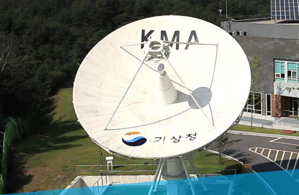
Eunha Sohn gives a presentation on NWC-SAF products adapted to the Korean COMS satellite.
Length: 30 min
Author: Eunha Son (KMA)
Firstly, the characteristics of synoptic weather which convective cloud occurs over eastern Asian region will be mentioned and the thunderstorm monitoring system with radar data which KMA forecasters use will be also introduced. And then I will present our convective cases and explain them with satellite, radar and other NWP data.