
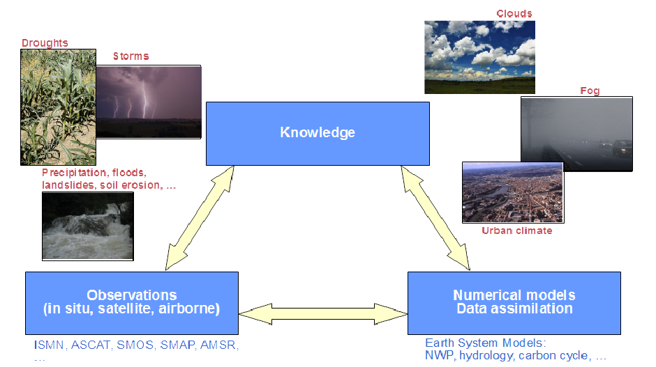
Hydrology & water management
Listed here are other resources related to Hydrology & water management tag:
Note: click on an image to open the Resource
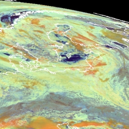
During the 9th and 10th July the Baltic States and Finland experienced heavy rain as a wave-cloud formed in moist and warm south-easterly air stream.
This study concentrates on two areas at the opposite sides of the low pressure area. The objective is to provide a detailed insight into the mechanisms that govern the formation of convection within a cold front (Finland) as well as prolonged rain within an occluded front (Lithuania).
In Lithuania the event was characterized by extreme rainfall (locally more than 250 mm in 3 days), leading to floods and severe damage. The south-westerly gusts on the 10th August caused uprooting of trees and further economic loss in excel of 45 million Euro. In Finland the most remarkable events were those connected with the passing of the cold front in the evening of August 9, associated with the intensive precipitation and lightning.
This case study will present the circumstances and explain the processes that led to severe flooding in both Slovenia and Croatia in September 2010.
Last days of summer 2010, Slovenia and Croatia were marked by heavy rainfall and floods. The precipitation amounts in some parts of Slovenia was exceeding all recorded rainfall amounts in the last 100 years causing immense property damage and even human casualties. In the western part of Slovenia locally more then 500 mm of rain fell in 48 hours. Huge part of Slovenian territory was flooded, which included also more than 8200 houses.
The amount of rain in Croatia was not so great. In Gorski Kotar region (mountain area in the western part of Croatia) and in Istria in three days 200 to 300 mm of rain was reported causing mostly flash floods. The main problem in Croatia was the water that was brought by Sava river from Alpine region. Because of the instantaneous unit hydrograph the southern part of Zagreb was flooded for several days.
Even though the prognostic material was giving the clear sign of a probability of heavy rain and the warnings were issued several days in advance, the amount of precipitation was so big that the damage was not possible to avoid.
This case study explains the processes that led to severe flooding and specialty of this study is that it brings and introduces H-SAF as a tool for detail monitoring which is of great help to the meteorological and hydrological specialists during and after the event. In this case study products of H-SAF are explained and some samples are presented.
During the night from 24 to 25 September 2010 heavy rain caused flash-flooding of the town of Pula and the surrounding area.
The case study shows that the flash floods in Pula were the result of a convective system which developed in the convergence zone caused by a specific placing of two Mediterranean cyclones. Generally, the Mediterranean region is recognized as one of the most cyclogenetic regions in the world. Mediterranean cyclones are classified in 3 major types: Genoa cyclones, Adriatic cyclones and non-Genoa cyclones. Although it is rather rare, the major-type cyclones can exist simultaneously belonging to the theoretical category of twin or eyeglass cyclones. The most common twins are the simultaneous Genoa and Adriatic cyclones (Brzovic, 1999), therefore classified as the 4th type of Mediterranean cyclones. Depending of the season and general synoptic conditions, the paths of the cyclones in the Mediterranean basin are diverse. On their way through this complex geography, they can produce a range of extreme weather phenomena such as heavy orographic precipitation, thunderstorms, supercells and mesoscale convective systems.
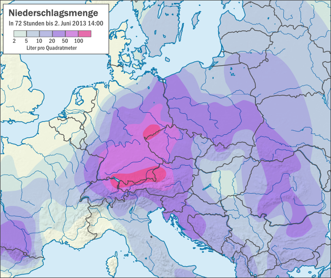
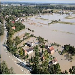
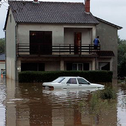
This case study is analysing floods that occurred in central Europe during the period of June 2013.
The case study is analyzing floods in central Europe during the period of June 2013. The case starts with the development of a trough over central Europe on 22 May, seven days before the floods. From 29 May on, the trough intensified the rainy weather, causing southern and southeastern Germany to experience continuous rain over several days. Altogether the countries of Germany, Poland, Czech Republic and Austria were seriously affected by floods and the damages in Bavaria (Germany) only were estimated to 1.3 billion euros.
Tristan L'Ecuyer presents satellite precipitation products based on radar technology.
Length: 30 min
Author: Tristan L´Ecuyer (University of Wisconsin-Madison)
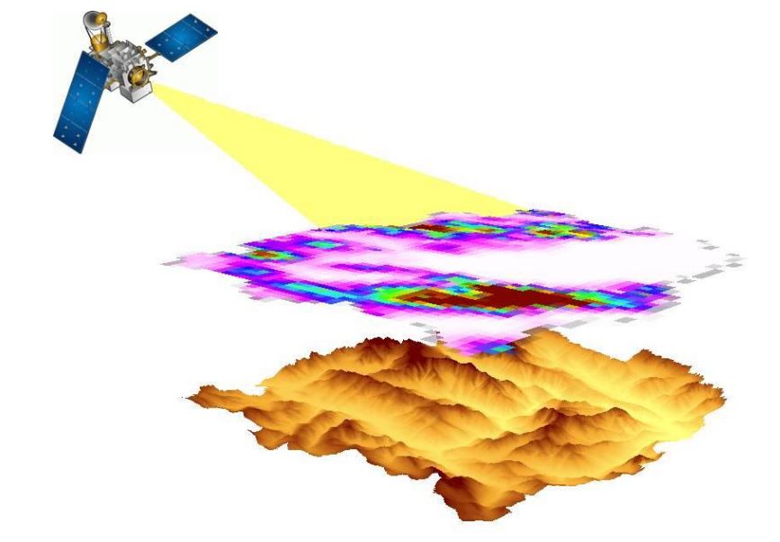
Radars provide the most direct means of remotely measuring precipitation over large areas. The value of ground-based radars for indicating the location and intensity of rainfall was recognized shortly after the first surveillance radars were developed during World War II. Since then radar networks have been widely used to estimate precipitation accumulations, track storms, and provide valuable information to the public. However, vast areas of the Earth including oceanic, mountainous, and densely forested regions are largely inaccessible to ground-based instruments. As a result, much of our knowledge of precipitation in such areas derives from passive satellite measurements that can suffer from uncertainties owing to the indirect relationship between radiation measured at the satellite and rainfall at the surface. Satellite precipitation radars offer some of the benefits of their ground-based counterparts with the enhanced coverage afforded by orbiting the Earth. To date three such radars have been launched providing a new perspective of global precipitation from tropical rainfall to polar snows that complements the longer-term record provided by passive instruments. This lecture will describe the physical principles used to relate the reflectivities measured by these radars to precipitation intensity. We will examine the main features of the associated precipitation retrieval algorithms and some of the important factors that need to be considered will be highlighted through illustrative examples. We will conclude by contrasting the strengths and limitations of satellite radars against passive satellite sensors and ground-based radar systems.
Emmanouil Anagnostou reviews a comprehensive error analysis of the currently available global-scale HPE products based on a number of major flash flood-inducing storms.
Length: 30 min
Author: Emmanouil Anagnostou (University of Connecticut)
The advancements in satellite rainfall observations over the past decade have opened new horizons in hydrological applications at global scale. Specifically, newly available high resolution (8-25 km, 1-3 hourly) satellite precipitation estimates (HPE) have allowed researchers to consider their potential integration with hydrologic models for flood modelling applications. However, performance evaluation of HPEs in cases of major flash flood-inducing storms is needed to assess their ability to represent the high rainfall variability associated with these storms. Furthermore, derivation of error metrics are usually based on long time records (years) thus results are bulked and cannot provide clear evidence for the efficiency of high resolution satellite precipitation products in quantifying heavy precipitation events that are usually responsible for the occurrence of flash floods. In this talk we will review a comprehensive error analysis of the currently available global-scale HPE products based on a number of major flash flood-inducing storms that occurred in Southern Europe and Western Mediterranean basins over the past 12 years. Quality controlled rainfall datasets derived from high-resolution radar-rainfall estimates and/or dense rain gauge network observations are used for reference. The ability of satellite-rainfall to represent the magnitude and spatiotemporal patterns of each storm is examined. Strengths and limitations of each product are highlighted and general findings are anticipated to serve as a valuable reference to both hydrologists and satellite product developers. Finally, the error propagation from rainfall to flood simulation is examined, and error correction techniques based on a newly developed NWP-based correction technique are evaluated in terms of their impact on flood prediction efficiency.
Matteo Picciani presents the recent upgrades and future developments of the H-SAF products for the monitoring of convective precipitation.
Length: 30 min
Author: Matteo Picchiani (CNMCA)
In the presentation the recent upgrades and future developments of the H-SAF products for the monitoring of convective precipitation will be highlighted. The application of a new version of NEFODINA, a tool developed by CNMCA for the detection of convective systems, will be introduced and different improvements such as the application of a calibration formula and the release of new products versions, developed for monitoring the MSG SEVIRI full disk area, will be shown.
In this module you will learn how snow cover and snow water equivalent are determined by satellite instruments and how this data can be applied for regional climate studies.
Snow cover is an important climate variable on both local and global scales. It affects the planetary radiation budget through high albedo values. It influences the hydrological cycle globally and locally, and for many locations it is an important source of water. In this module you will learn how snow cover and snow water equivalent are determined by satellite instruments and how this data can be applied for regional climate studies.
Jean Christophe Calvet talks about the assimilation of H-SAF soil moisture products into models.
Length: 28 minutes.
In situ and satellite-derived soil moisture observations are needed to better understand and simulate land surface processes. This has been the subject of active research for more than two decades. The transfer to operations in weather forecast, hydrometeorological, and drought monitoring applications also implies the integration of satellite-derived observations into models. Examples of the use of soil moisture observations, simulations, and data assimilation are presented.
Silvia Puca introduces the H-SAF and its products.
Length: 23 minutes.
H SAF started in 2005 and aims to provide remote sensing estimates of relevant hydrological parameters: instantaneous rain rate and cumulated rainfall, soil moisture at surface and in the root zone, snow cover and water equivalent. The project involves experts from 12 national meteorological and hydrological European Institutes of Austria, Belgium, Bulgaria, Finland, France, Germany, Hungary, Italy, Poland, Romania, Slovakia and Turkey, and from ECMWF.
The H SAF main objectives are: to provide new satellite-derived products (precipitation, snow parameters and soil moisture) from existing and future satellites with sufficient time and space resolution to satisfy the needs of operational hydrology, and to perform independent validation in order to assess the usefulness of the new products for fighting against floods, landslides, avalanches, and evaluating water resources.
David Fairbairn presents examples of downloading, converting the format to regular netCDF files and visualizing the data in Python.
Length: 19 minutes.
H-SAF root-zone soil moisture products are freely available online. They are currently stored in daily files on a reduced Gaussian grid in GRIB binary format, which increases storage efficiency. Examples of downloading, converting the format to regular netCDF files and visualizing the data in Python are presented. The new metview-python package is also introduced, allowing direct applications in GRIB format.
David Fairbairn discusses the theory behind the near-real-time and data record RZSM products.
Length: 25 minutes.
ECMWF provides the core root-zone soil moisture (SM) products for H SAF through an Extended Kalman filter assimilation system, running independently of the NWP system. Space borne scatterometer-derived surface SM observations are assimilated into the root-zone (0-1 m) SM of the H-TESSEL land surface model. In this presentation, the theory behind the near-real-time and data record products is discussed.