
Hydrology & water management
Listed here are other resources related to Hydrology & water management tag:
Note: click on an image to open the Resource
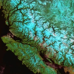
Semih Kuter talks about improvement of the EUMETSAT H-SAF H35 effective snow-covered area product by Multivariate Adaptive Regression Splines.
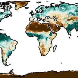
The pre-operational daily H35 effective snow-covered area product of H-SAF spatially spans the Northern Hemisphere and it is the successor of the operational Pan-European H12 product. Both products are at ~1 km resolution and developed through the H-SAF project of EUMETSAT by exploiting AVHRR channels. During the AS activity (i.e., H_AVS_18_03), an alternative machine learning-based approach is applied on H35 product to improve its accuracy. The new version of H35 product is realized through multivariate adaptive regression splines (MARS) algorithm. AVHRR reflectance data, as well as the well-known snow and vegetation indices (i.e., NDSI and NDVI), are used as predictors to generate the new MARS-based H35 product. The reference fractional snow-covered area (fSCA) maps are obtained from higher resolution Sentinel 2 imagery. Rigorous assessment on the final MARS-based H35 is performed over the Northern Hemisphere within a temporal domain from Nov 2018 to Nov 2019 by using i) Sentinel 2 derived reference fSCA maps, ii) ERA5-Land snow depth data, iii) MODIS MOD10A1 NDSI snow cover data, and iv) in-situ snow depth data. An additional visual assessment is also carried out by comparing MARS-H35/MODIS false-color and MARS-H35/Sentinel 2-derived reference fSCA image pairs over various geographic regions.
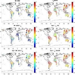
Filipe Aires presents statistical approaches to assimilate soil moisture information.
Land surfaces are characterized by strong heterogeneities of soil texture, orography, land cover, soil moisture, snow and other variables. These are very challenging to represent accurately in radiative transfer models, which currently still have limited reliability over land. In this study, we compare two statistical modeling approaches: the traditional CDF-matching used routinely in NWP centers (used here as a normalization and as an inversion technique), and the Neural Network (NN) methods. NNs and CDF-matching are compared and combined. Two cases are considered: (1) the more traditional inversion scheme, and (2) the forward modelling that could be attractive for assimilation purposes. It is shown that in the context of ASCAT, the inversion approach seems better suited than the forward modelling but this could be different for another type of observations. It is also shown that it is possible to combine the global model obtained using the NN and the localized information of the LSM offered by the CDF-matching. A first assessment is performed over the US using in situ soil measurements. Finally, we will present future plans to develop a forward operator for low-frequency microwave channels (SMOS, AMSR-E, SMAP, CIMR) based on a statistical modeling of surface emissivities over continental, snow-ice and sea ice surfaces.
Annalina Lombardi demonstrates that that areal precipitation estimation including satellite information in addition to surface observations has a high performance compared to that which uses only the rain gauge data.
Satellite-based remote sensing provides a significant contribution for hydrological predictions due to its wide coverage and increasing tempo-spatial resolutions. Although current observed areal precipitation estimation is mainly based on point rain gauge measurement interpolation, the ability to deduce spatially distributed data from point measurement depends on the design and density of the sensor network.
A possible approach to have a correct representation of the rain field at the hydrological scale (up to a few hundred meters) could be to merge rain gauge data with gridded rainfall data obtained from remote sensing techniques, and the availability of such data in near-real time is a unique opportunity for the operational hydrology community. In this study we propose the application of advanced downscaling techniques based on Cellular Automata Algorithm for rainfall spatialisation using satellite precipitation products for hydrological applications. The method proposed to merge rainfall estimates measured in different spatial scales is based on the data assimilation concepts with particular emphasis on the transformation of point data to areal data. The work wants to prove that the areal precipitation estimation including satellite information in addition to surface observations has a high performance compared to that which uses only the rain gauge data.
Aynur Sensoy assesses the impact of the snow product for runoff prediction results (KGE> 0.85) and also demonstrates it in comparison to a well-known data set of MODIS.
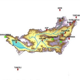
Developing satellite technology offers new products to simulate different hydrological processes. These products are invaluable in hydrological applications for mountainous areas where observation data is relatively limited. The H SAF project offers snow products over complex topographies.
The daily snow cover dataset derived by H SAF SE-E-SEVIRI (H10) is evaluated on the mountainous terrain of the Upper Euphrates Basin. Snow-covered area data is processed and analyzed. Snow depletion curves are extracted and used as basic forcing data in a conceptual model. The impact of the product is assessed by the model performance for runoff prediction results (KGE> 0.85) and also demonstrated in comparison to a well-known data set of MODIS.
Lorenzo Alfieri shows recent advances in high resolution satellite products and their use in hydrological modelling.
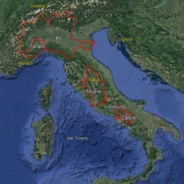
This work shows recent advances in high resolution satellite products and their use in hydrological modelling. In a set of experiments, the distributed hydrological model Continuum is set up for the Po River Basin and forced by satellite precipitation and evaporation, while soil moisture and snow water equivalent are ingested through a data-assimilation scheme. All satellite products produced skilful estimates of river discharge. Satellite based evaporation and snow water equivalent marginally improve (by 2% and 4%) the mean Kling-Gupta efficiency at 27 river gauges. Interestingly, a model calibration heavily relying on satellite data provides skilful reconstruction of river discharges, paving the way to full satellite driven hydrological applications.
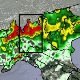
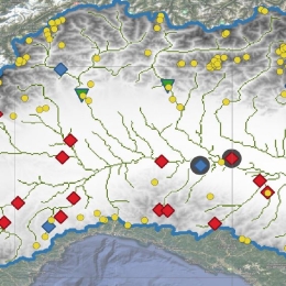
Stefano Federico presents a study, a comprehensive analysis of the July 2021 event that occurred over Como Lake (Italy), trying to provide a complete overview of all the data currently available for the analysis of this type of events.
In recent years, in some areas over Europe, there has been an incidence of extreme weather events that have severely impacted people, structures, and infrastructure, causing damage and loss. The scientific literature indicates that the scenario is evolving and that there is an increasing number of severe weather events, which makes the use of as much data as possible particularly useful.
In this study, a comprehensive analysis of the July 2021 event that occurred over Como Lake (Italy) was performed, trying to provide a complete overview of all the data currently available for the analysis of this type of events.
Marco Petracca provides an overview of SEVIRI-based precipitation products: H60, H61, H63 and H90.
Over the past few years, there has been a rising in intense precipitation events, resulting in severe effects on people and infrastructures. To meet the challenge of analysing weather events comprehensively and globally, the use of information from satellite is playing an ever-increasing role in the field of meteorology. In this context, H SAF provides data sets and products for operational hydrological applications: an overview of SEVIRI-based products will be given: H60, H61, H63 and H90. Their validation process and a direct inter-comparison between the same products with different spatial coverage will be shown to demonstrate their extended spatial validity.

Examples of downloading, reading, and displaying snow cover and snow water equivalent data in Python are presented.
H SAF snow cover and snow water equivalent products are comprised of either Near Real-Time (NRT), Offline or Climate Data Records (CDR), which are freely available at the H SAF data portal. Examples of downloading, reading, and displaying snow cover and snow water equivalent data in Python are presented.
The session includes a summary of H SAF precipitation products, with particular attention to the most recent products.
The session includes a summary of H SAF precipitation products, with particular attention to the most recent products. The procedures to get access to the data, both for short range repository (last 60 days) and longtime archive data will be described. Moreover, the main data formats will be briefly presented, including the expected format changes in the near future. Python scripts and a Jupiter notebook developed for reading and visualization of precipitation data will be also presented.
Additionally, an example of Flood modelling with satellite rainfall data in Africa will be shown. Flood modelling over data scarce regions is challenging. Satellite rainfall data offer a viable tool to force hydrological models and provide discharge prediction at ungauged sites. However, being an indirect type of measurements, satellite rainfall observations can be subjected to significant bias and might be suboptimal over mountainous terrain. Here we show that model recalibration or bias correction even with a few rain gauges can provide boost hydrological model performance and thus make satellite rainfall data a valid solution to obtain discharge.
A demonstration session that gives an overview on how to download, read and visualize H SAF soil moisture data using the Python programming language.
The demonstration session gives an overview how to download, read and visualize H SAF soil moisture data using the Python programming language. Jupyter notebooks are used to present code examples, which are hosted at GitHub. H SAF Surface Soil Moisture (SSM) and Root-Zone Soil Moisture (RZSM) products are comprised of either Near Real-Time (NRT), Offline or Data Records (DR) products, which are freely available after user registration at the H SAF data portal. RZSM products are generated fromassimilating the ASCAT-derived surface SM in the ECMWF/H SAF land data assimilation system. Additionally, a hydrological exercise will highlight the added value of soil moisture satellite data for flood prediction. Soil moisture conditions have a great impact on the transformation of precipitation into runoff. A correct estimation of the initial soil moisture condition is a critical aspect for operational flood prediction. In the exercise we will test the sensitivity of flood response to initial soil moisture conditions using a simple hydrological model over an African Basin.
Sebastian Hahn from the Vienna Technical University talks in his presentation about the different sensors for the retrieval of soil moisture onboard polar orbiting satellites and describes the SM algorithm developed at the TU-Wien.
Although soil moisture represents only about 0.005% of the global water resources, it is one of the crucial variables in hydrological processes, influencing the exchange of water and energy fluxes at the land/atmosphere interface. For many environmental studies it is important to have accurate estimates of the spatial and temporal variations of soil moisture (e.g. hydrology, meteorology). Advances in satellite remote sensing have shown the potential of estimating soil moisture using various remote sensing techniques. This presentation will focus on an introduction using active and passive microwave remote sensing for the retrieval of soil moisture. In case of the active retrieval a detailed description of the semi-empirical model used for the METOP ASCAT soil moisture product will be shown step by step, especially highlighting assumptions and limitations. In the end various applications using satellite based soil moisture products will be summarised.
Stefania De Angelis shows in her presentation the different categories of Hydro-SAF precipitation products derived from polar orbiting satellite data.
Monitoring and measurement of precipitation from satellite is an important capability for many types of users, such as the Meteorological Services, Hydro-geological Services and the structures of civil protection. The consortium H-SAF, within EUMETSAT, has among its objectives to provide continuous operational products for instantaneous measurement of rainfall using data from microwave instruments, on-board polar satellites, in synergy with the infrared data of the geostationary satellite MSG. In addition to the production operation, the HSAF provides validation service on each product and carries out independent validation of the benefits of the novel H-SAF satellite-derived data on hydrological practical applications.