
Identify and interpret fields and derived products
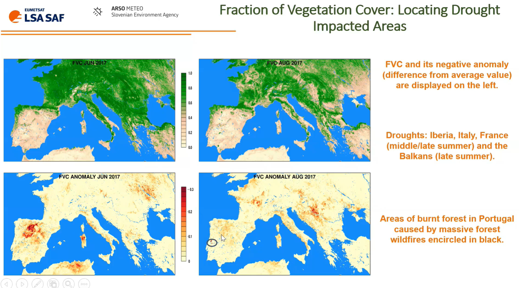
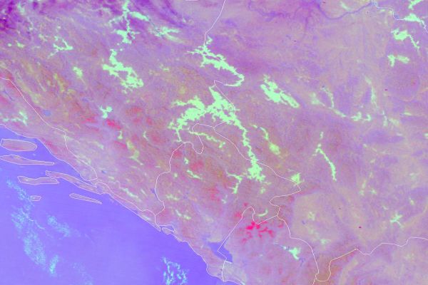
Bostjan Muri talks about using LSA SAF data and vegetation anomalies for drought monitoring.
In this presentation, we explore numerous real world applications of the use of LSA SAF data. Our focus is identifying heatwaves and droughts based on satellite data. Vegetation anomalies can be particularly helpful for drought monitoring. These show cases are selected in order to highlight the benefits of specific applications using LSA SAF data and its added-value when compared with other existing sources of observations (either satellite or meteorological stations) as well as model output.
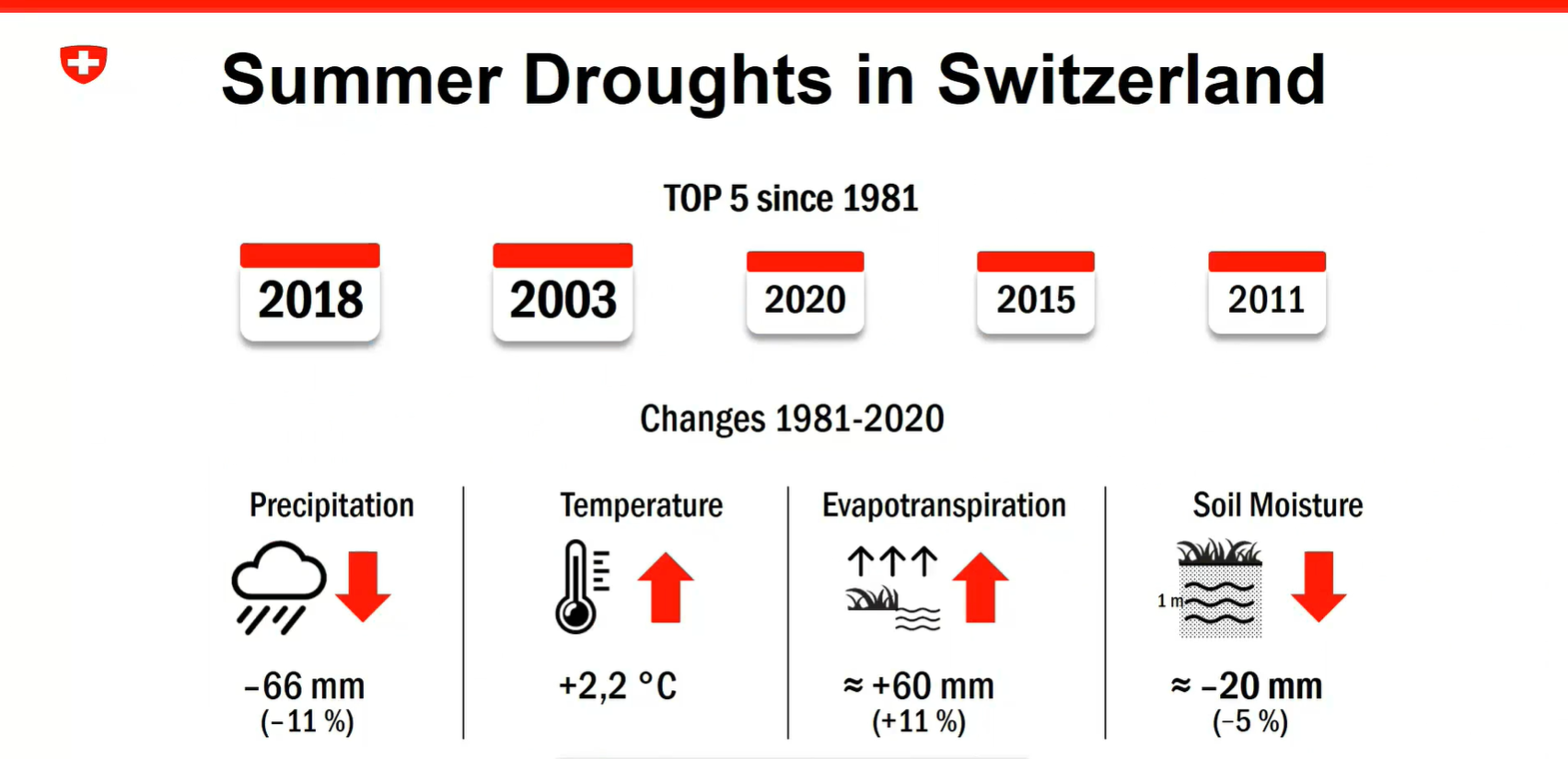
Anke Duguay-Tetzlaff and Vincent Humphrey present about the recent Swiss drought monitoring project and use of EUMETSAT satellite data for drought monitoring.
The Swiss government has started a drought monitoring project in 2023. The goal is to set an operational drought monitoring and warning system in the upcoming years. In a pre-study we have analyzed the potential of EUMETSAT satellite data for climatological drought monitoring in Switzerland. We will present possibilities and shortcomings of the different analyzed soil moisture, land surface temperature and evaporation data and provide an outlook on how we plan to integrate EUMETSAT data in the system.
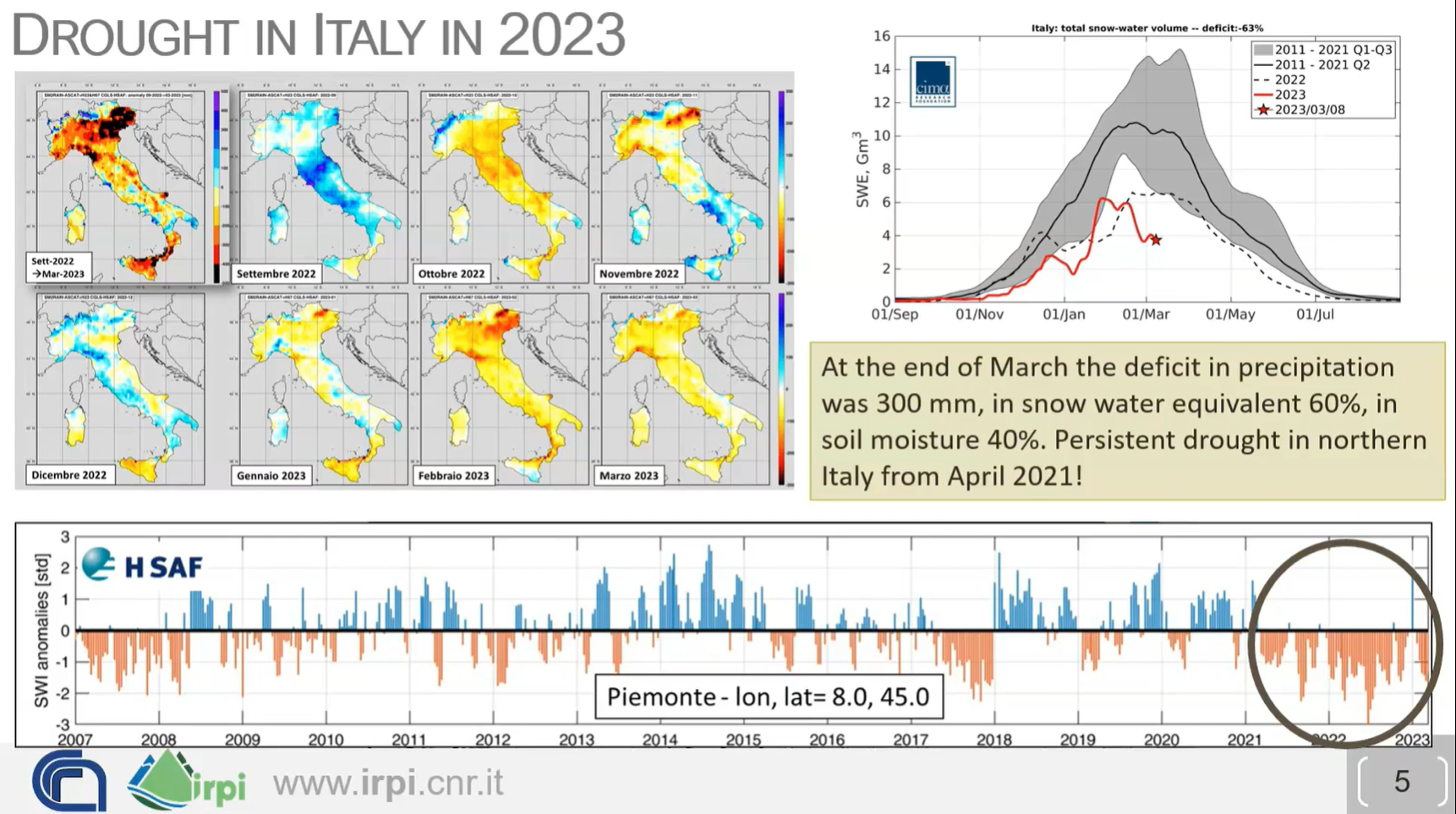
Luca Brocca shows how to combine multiple satellite derived variables to monitor drought.
How do we monitor drought? Is it enough to use only precipitation data and calculate the SPI (Standardized Precipitation Index)? New satellite-derived products (precipitation, evaporation, soil moisture and snow) offer additional ways to monitor drought in space and time, to assess WHERE the water is (surface soil, root zone soil, snowpack), and thus to know WHEN the water will be available. Real-world case studies will be analyzed together with the participants, also using an interactive platform (https://explorer.dte-hydro.adamplatform.eu/). The objectives of the lecture are: (1) to assess drought risk based on (new) satellite observations, and (2) to translate drought risk information into real-world decisions for water resources management (e.g., reservoir management, irrigation, hydropower generation).
João Martins talks about using Land Surface Temperature (LST) in heatwave monitoring using LSA SAF datasets.
Heat and water stress leave clear signatures on land surface variables that can be monitored from space. The LSA SAF has been providing satellite datasets and products that allow the characterization of the surface energy budget and the monitoring of vegetation growth and stress. We will show that combining information on the surface temperature diurnal cycle and on vegetation state provides a different perspective on the spatial extent and time evolution of droughts and heatwaves, and reveals underlying soil vegetation-atmosphere feedbacks.
Vesa Nietosvaara showcases how the MTG's FCI instrument will improve the quality of satellite data, especially for users in high latitudes.
The first Meteosat Third Generation (MTG-I) satellite with Flexible Combined Instrument (FCI) was launched at the end of 2022. It will be followed later in 2024 by MTG-S Satellite with Infrared Sounder onboard. MTG will carry novelty instruments – Infrared Sounder, Lightning Imager and Ultraviolet Visible Near-infrared (UVN) Spectrometer - in the GEO orbit. Meteosat Third Generation aims to secure continuity and to increase the capabilities of the Meteosat satellites in response to requirements of the future forecast/nowcast systems. Altogether, the new and enhanced capabilities will allow us to make a huge step in better monitoring of our environment, and allowing development of new applications.
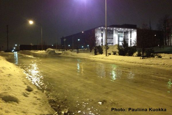
Marjo Hippi explains how FMI deals with slipperiness during winter.
Icy and snowy sidewalks are very typical phenomena in Finland during winter. Near zero temperatures and slipperiness due to ice and snow on sidewalks increases the pedestrians' slip risk. Almost every second person slips annually in Finland and around 50 000 persons (1 % of Finnish population) are injured needing medical attention. Slip injuries cause huge economic losses, long sick leaves, and human suffering. The Finnish Meteorological Institute (FMI) has developed a numerical weather model that predicts the sidewalk slipperiness from pedestrians' point of view. The model classifies the sidewalk slipperiness into three classes: normal, slippery, and very slippery. Very slippery sidewalk condition mean that the slip risk is increased. Typical situations for very difficult sidewalk situations are packed snow, freezing or ice layer covered by water or snow. The model is a tool for duty meteorologists when issuing warning about slippery sidewalk condition.
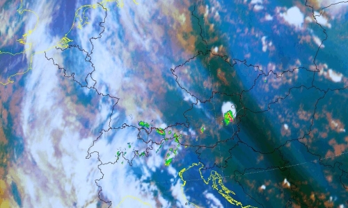
Thomas Krennert (ZAMG) talks about the importance of moisture gradients in analysing the possibility of development of deep moist convection.
The exact predictability of convection in the Alpine region in the absence of fronts in weak-surface-pressure-gradient-situations during the warm season remains challenging for forecasters. The development into single-cell deep moist convection SC-DMC under these conditions depends on the availability of well-known ingredients like low level moisture, steep tropospheric lapse rates and sufficient lift. Satellite studies have shown that favourable locations for the first onset of SC-DMC resulting from widespread shallow convection over mountainous terrain are water vapour gradients in the middle or upper troposphere UTMG (upper tropospheric moisture gradients, Krennert, et al., 2003, https://doi.org/10.1016/S0169-8095(03)00067-X). The contributions of the respective ingredients related to UTMG supporting the initiation of DMC are discussed. A focus is set on moist symmetric instability MSI as a possible mechanism for favouring the transition from shallow to deep moist convection.
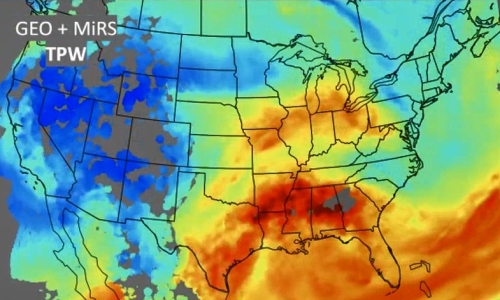
Ralph Petersen (University of Wisconsin) talks about forecasting satellite-derived moisture using all available observation data on moisture and Lagrangian methods to give forecasters more information on the possibility of storm formation.
The CIMSS Lagrangian NearCasts system 1) expands the utility of clear-air sounding and products related to the pre-convective environment (from MTG-IRS Sounder and MTG-Imager) into the 1-9 hours period before storm formation and 2) now combines Geostationary Infrared Products with less frequent microwave products from multiple Polar Orbiting systems to fill information gaps in cloudy areas. For a heavy precipitation event, quantitative measures of both retrieval and short-range forecast accuracy are provided, including a new, non-uniform bias correction approach, and explorations of predictive clear-sky RGBs.
Including “all-weather”, real-time MiRS retrievals not only provide a more visually pleasing product (improving coverage by 30-40%), but also exposes forecasters to here-to-fore underutilized POES observations over land.
Validation against hourly surface-based GPS-TPW observations testify to the ability of the Satellite-based products to capture observed small-scale moisture features properly. Results show error growth rates < 1%/hour (without initial shocks) and support applying non-uniform bias corrections derived over 5mm bands to assure realistic TPW distributions.
Because RGB presentations are more popular than quantitative retrieval product displays the parcel-based Lagrangian NearCast approach was also used to “predict” clear-air RGBs based on the projection of radiance, with quantitative values overlaid. Examples of initial tests will be shown.
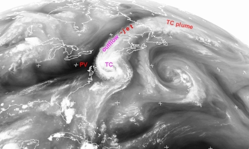
Christo Georgiev (NIMH) discusses the effect of vorticity on tropical cyclones and development of severe thunderstorms, through the scope of water vapour imagery.
Water vapour (WV) images provide useful information to anticipate the effects of upper-level dynamic environment on the intensity of a tropical cyclone (TC) as well as on its extratropical transition (ET), a gradual process in which a TC loses tropical characteristics and becomes more extratropical in nature. Analyses of WV imagery shows that during ET stage over subtropical areas, advection of potential vorticty anomaly can influence the ET and control the process.
Large amounts of water vapour, originated by TCs may be involved in transfer of moisture by planetary waves, associated with ET developments and give rise to a narrow regions of strong meridional water vapour flux. The presentation shows WV imagery synoptic-scale analysis, which shows supply with additional large amount of moisture of an existing already favourable convective environment. The
combination lead into an environment with very high CAPE and potential to accelerate upward, acquiring kinetic energy and forming strong vertical motions in a deep tropospheric layer. The process is illustrated by a case of catastrophic hailstorm over Bulgaria, Eastern Mediterranean.
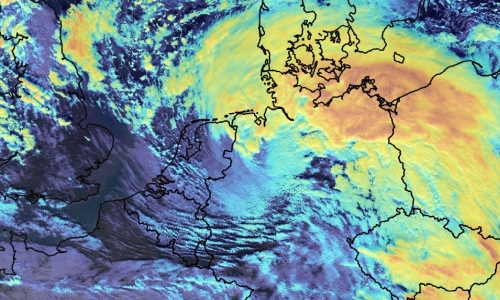
Christian Herold (DWD) investigates the usefulness of IASI L2 products in nowcasting, detecting and analyzing sting jets in rapid cyclogenesis.
Strong winds southwest of the center of a Shapiro-Keyser-Cyclone are often associated with a cold conveyor jet or a sting jet. The sting jet is a strong mesoscale flow with a very high damage potential. It is a massive challenge for NWP and forecasters to correctly predict a sting jet. The question is, can IASI profiles help forecasters for a better prediction of such mesoscale severe wind events connected with sting jets? In this specific context, some case studies will be presented.
Zsofia Kocsis (OMSZ) talked about the reasons behind the experiment of merging SYNOP data with the IASI L2 profiles.
Using IASI L2 profiles, different instability indices (e.g. Lifted Index, CAPE) and water vapour content in different layers can be determined, which provides information on the convective environment. These indices were studied in several convective cases which led us to try to merge the IASI profiles and Synop measurements. In this presentation we present the reasons why we choose to combine these different measurements and we also present some of our experiences with the blended IASI product.
Phil Watts and Loredana Spezzi (EUMETSAT) give an overview of the possibilities of water-vapour retrieval of the future EPS-SG satellites.
The METimage instrument on board of the future EPS-SG satellite series opens a new era for the retrieval of water wapour imaging products at EUMETSAT. Equipped with 20 channels covering the spectral range 0.4-13μm and including both Near infrared and thermal infrared water vapour absorption bands (0.9, 6.7 and 7.3μm), METimage will allow the retrieval of operational water vapour imagery products with unprecendented resolution (down to 500m) from a low-Eart orbit. These products are expected to greatly enhance the EUMETSAT service in support of numerical weather prediction, nowcasting and climate monitoring.
In this contribution, we report the retrieval approach chosen for METimage water vapour imagery products and demonstrate it using MODIS measurements. We focus in particular on the uncertainty and quality assessment planned for these products. We aim at gathering the fundamental user feedback to achieve the state-of-the-art retrieval and validation approach, and to foster cooperation and exchange for the analysis and characterization of these products once they become available. In particular, we would like to discuss key points that have an impact on the use of our products in forecasting applications (such as the use of prior forecast information in the retrieval, the product spatial resolution and content (e.g., uncertainties, quality indicators, diagnostic parameters, etc., and the advantage of combining NIR/IR measurements, not available from previous EUMETSAT missions).