
Identify and interpret fields and derived products
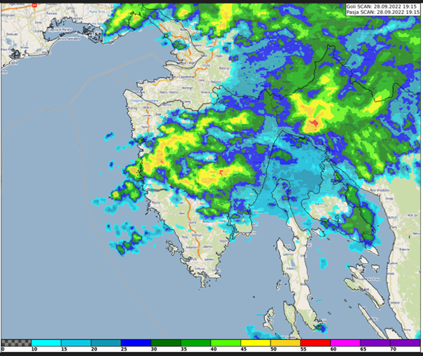
Case study about the extreme precipitation event in Rijeka, Croatia on 28 September 2022. The study focuses on the special case of convective development that caused the severe event.
This study accompanies the simulator.
Xavier Calbet goes over NWC SAF products available as well as some future planned ones. He also goes over the GEO-S software.
Go to lecture slides
Roberto Nicoletta talks about the H SAF P-IN-FCI (H40) instantaneous precipitation and P-AC-FCI (H42) accumulated precipitation products while Semih Kuter discusses the H SAF H43 Snow Cover Product.
This talk introduces the new H SAF P-IN-FCI (H40) instantaneous precipitation and P-AC-FCI (H42) accumulated precipitation products. They are an evolution of the H60 and H61 MSG products, having a significant increment in resolution and time frequency. They are put into evidence via some examples in the European region. Some details are shown to put show the 3-times enhancements in computing performances. How to download the new products through the new website interface is also introduced. EUMETSAT H SAF H43 daily snow cover product provides 2 km resolution binary snow maps derived from MTG-FCI observations. We outline key technical features of H43, demonstrate how to access and download the product via the EUMETSAT Data Services, and present initial validation results from the 2024–2025 winter season using MODIS reference data. Case studies from the European Alps and the Russia/Kazakhstan region illustrate performance across diverse landscapes.
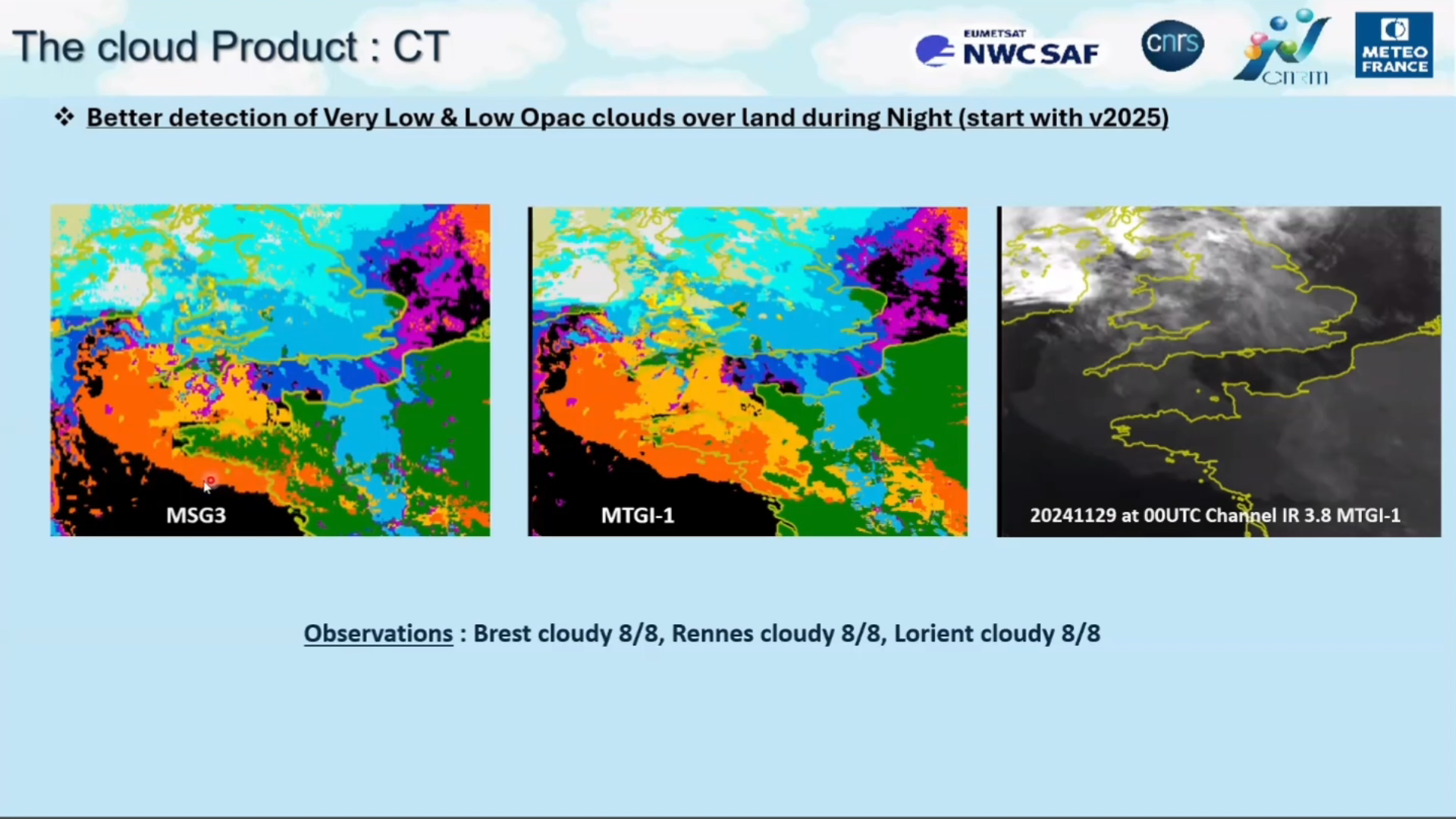
Jean Marc Moisselin and Emmanuel Fontaine talk about the benefits that MTG brings in regards to NWC SAF convection products.
Convection Initiation (CI) and Rapidly Developing Thunderstorm (RDT) are two convection products developed by Météo-France in the framework of NWCSAF. Both products fulfill requirement regarding the Day-1 MSG/MTG continuity (scores, visualization). RDT operated with MTG provides very positive features an the LI (Lightning Imager) instrument onboard MTG is very interesting and clearly add value to RDT. CI exhibits higher detection with MTG.
The Nowcasting SAF is planning a new software package dedicated to the new geostationary MTG-S Infrared Sounder instrument (IRS). This new software package will generate Satellite Humidity And Instability products (sSHAI) that will be key in Nowcasting using the IRS instrument. It will also deliver services to make the best use of MTG-IRS channels and combine its virtues with those of the MTG imager FCI.
In this Workshop you will learn about these revolutionary product and services. You will also have a taste of what will come in a few months with MTG-IRS by using in real world applications the prototype product obtained from the polar orbiting IASI instrument.
The Workshop is comprised of 4 presentations:
Part 1. X. Calbet (AEMET) - Introduction GEO-S
Part 2. N. Peinado-Galán (AEMET) - sSHAI prototype
Part 3. N. Peinado-Galán (AEMET) and X. Calbet (AEMET) - Practical cases with course attendants using SHAI on the EWC
Part 4. Miguel-Ángel Martínez (AEMET) - Other services from the GEO-S package: quickIRS, sSHAI_ES and Remapping tool

Learn more about:
- cloud classification scheme
- recognizing cloud types in satellite imagery
- a satellite product that provides cloud type information
- how cloud top temperature is derived from radiation measurements by satellite sensors
- when and where cloud top temperature provides valuable information to the forecaster
This module covers two different topics. In the first part, the module introduces Luke Howard's cloud classification system and tries to answer the question of whether cloud type classification is possible from space. The second part introduces the concepts of long- and short-wave radiation and how they are used in remote sensing and explains how temperature information is derived from radiation measurements. The module closes with examples of how cloud top temperature information is used in meteorology.
To access the resource click here.
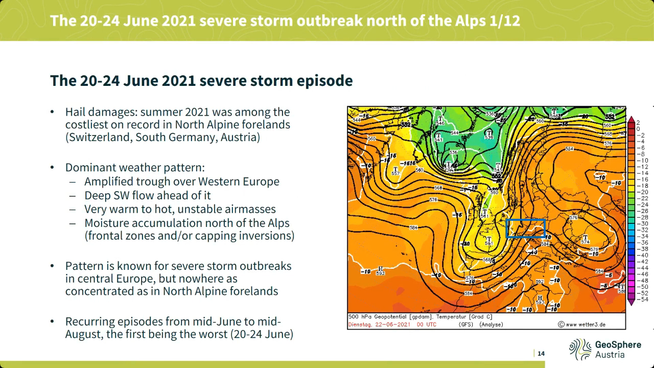
Georg Pistotnik covers the topic of drylines, shows it's relevance in severe weather development.
Drylines are boundaries separating warmer and drier from cooler and moister air, usually resulting from differential diurnal heating and therefore vertical mixing. The most common and distinct dryline in the Alpine region is the boundary between Foehn winds (dynamically driven) and upvalley/upslope circulations (thermally driven). Thunderstorms often form along drylines and intensify when they move onto their moist side, where CAPE and vertical wind shear are systematically enhanced and favor convective organization. This presentation highlights how station and readiosonde data, high-resolution satellite imagery and even webcam images can be integrated into the nowcasting of drylines and resulting thunderstorms, using some prominent cases of the past few years in the eastern Alpine region.
Lecture slides
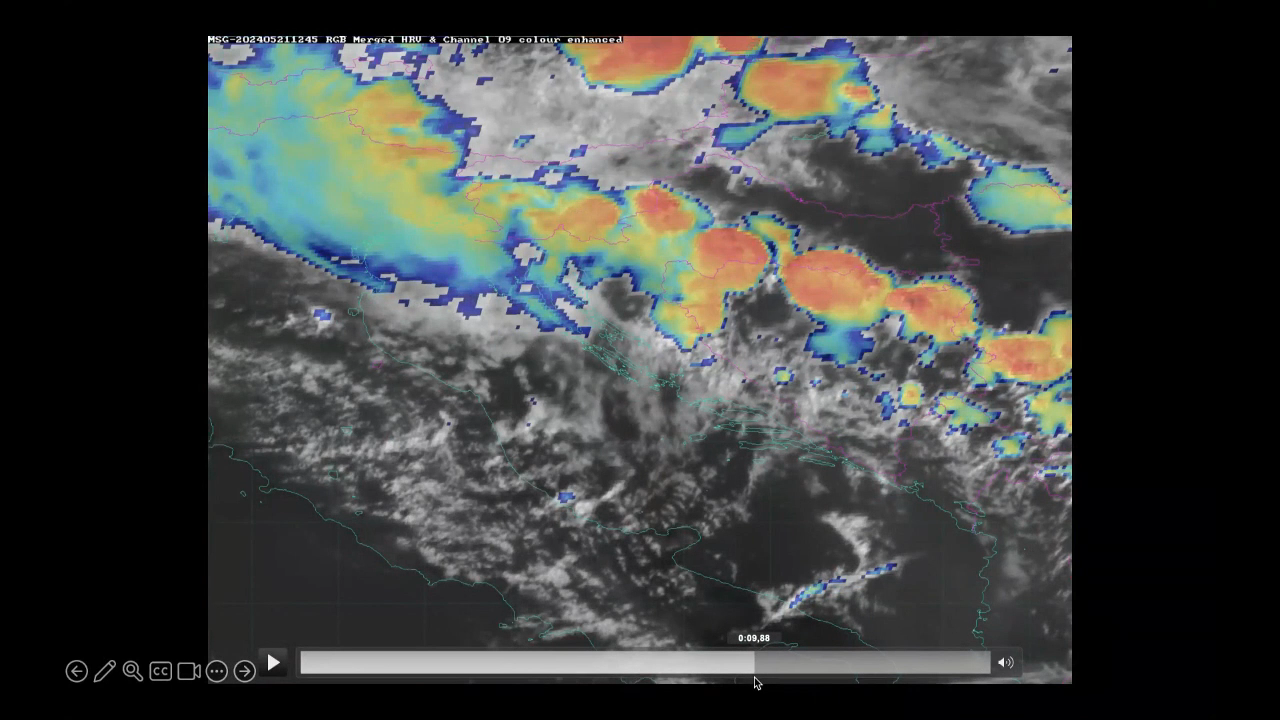
Katarina Katušić talks about Croatian Met Service work principles and schedules, case study and satellite products used during operational shift work.
The Weather and Marine Analysis and Forecasting Sector is a part of the Croatian Meteorological and Hydrological Service (DHMZ), and it is in charge of weather forecasts and warnings for the public and numerous companies. Over the years, we have gone through many challenges. Quite recently, during the lockdown, the earthquake severely damaged our headquarters, and even with those difficulties the work did not stop. We also prepare and present weather forecasts for national television. Furthermore, this presentation will cover the usage of weather satellite products in daily operational work.
Lecture slides
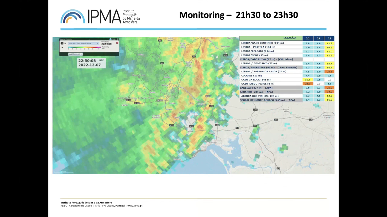
Jorge Ponte shows the challenges of being a forecaster, issuing warnings and discusses extreme precipitation event that affected Lisbon.
Extreme rainfall events in December 2022 caused significant losses in Lisbon, Portugal. This presentation examines these events to discuss whether it was possible (or not) to make a better forecast and issue earlier warnings. By analyzing various numerical model products from the preceding days alongside real-time monitoring data (satellite, radar, stations), the presentation will explore the operational forecaster's decision-making process during extreme weather situations.
Lecture slides
A conceptual model on DIBS: A special kind of Cirrus clouds formed by dust
The strongest influence of DIBS, and especially of dusty cirrus, on surface weather is mainly the reduced solar radiation reaching the ground as dust particles act as condensation nuclei and form clouds where otherwise no clouds would have been present. As current numerical weather prediction models do not accurately account for microphysical cloud formation processes caused by the additional dust at higher atmospheric levels, predicted maximum temperatures often have a considerable bias towards higher values.
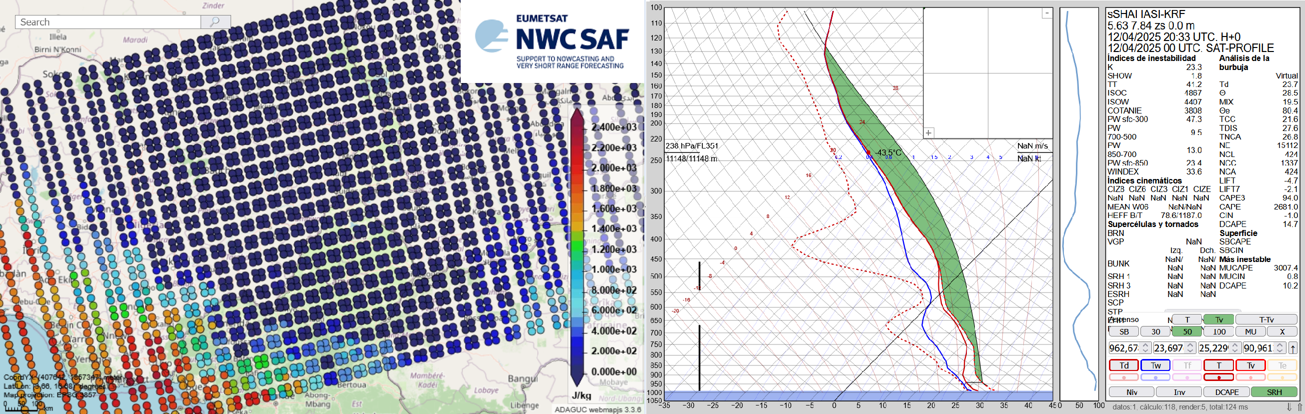
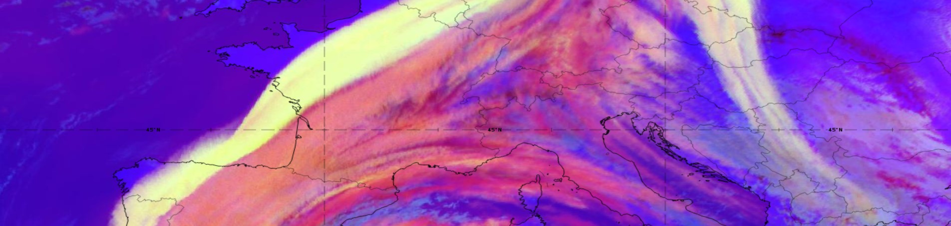
Case Study of the pre-convective environment of 19th May 2021 using IASI sounder data.
This Case Study of the pre-convective environment of 19th May 2021 using IASI sounder data focuses on exploring how the use of IASI retrievals added additional value to the forecast of the incoming storm over Hungary.
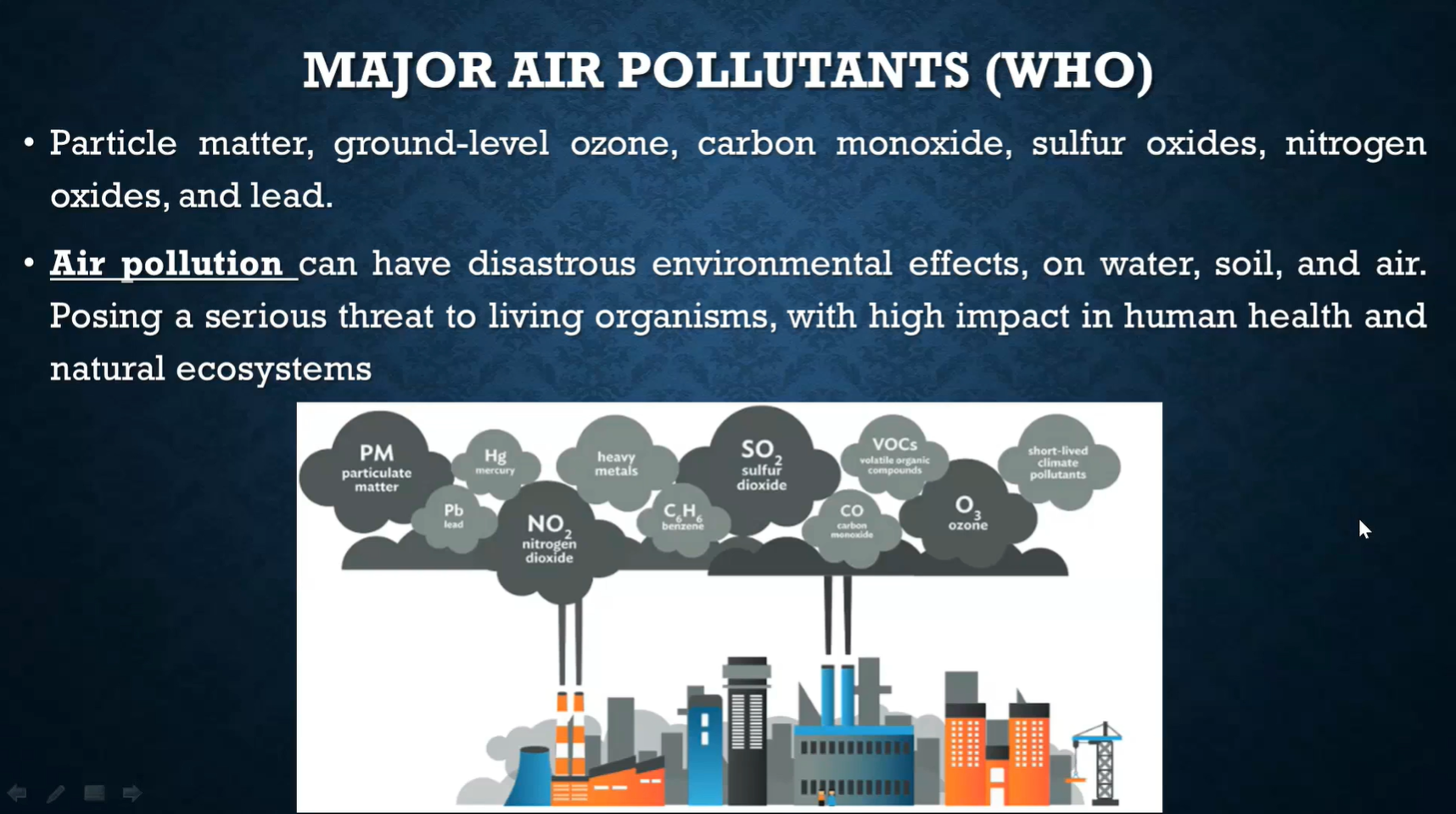
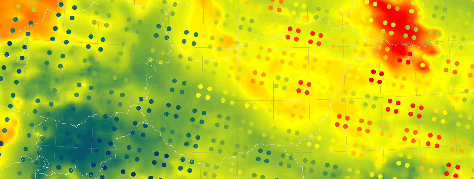
Ana Russo and Rita Durão talk about heatwave impact on air quality, pollutants and evaluation of air quality.
Heatwaves often lead to low air quality levels. Very high to extreme temperatures combined with stagnant air conditions increase air pollutants concentrations, such as tropospheric ozone. This effect might be emphasized when drought conditions also occur, which contributes to increasing fire danger and decreasing air quality levels too. Air pollution impacts on health are consequently an important issue, together with the drawbacks on ecosystems. This lecture will provide insights into the detection, monitoring, and evaluation of air quality impacts, using among others, remote sensing products.