
Identify and interpret broad scale, synoptic and mesoscale systems
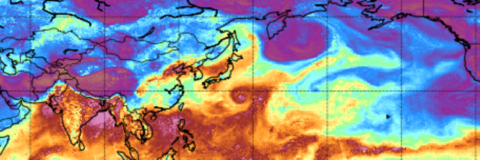
Have you ever wondered what an Atmospheric River is or how to recognize it in model or satellite data? The freshly released training module will assist you by guiding you step by step through the identification process.
First you will learn some basic facts on Atmospheric Rivers; how and where they are created, their typical characteristics and their appearance in satellite and model data. Step by step, you will then be guided through the identification process until you are certain that you are dealing with the phenomenon that is called an Atmospheric River.
Later stages of Atmospheric Rivers are sometimes tricky to identify as they are often merged with mid-latitude frontal systems. But here again, model fields and the timely evolution can give a precise answer whether there is an embedded AR or not.
And finally, it is well invested time going through this training module as ARs are responsible for many floods and heavy precipitation in Western Europe once they make a landfall.
The purpose of this Training Module is to provide step-by-step instructions for identifying Atmospheric Rivers.
This mini-module is part of a series of MTG mini modules produced by EUMETSAT/EUMeTrain with the aim of providing quick and useful learning experience about the new satellite products.
In this exercise you will learn about different MTG products for severe weather forecasting.
Enter the mini-module.
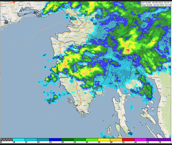
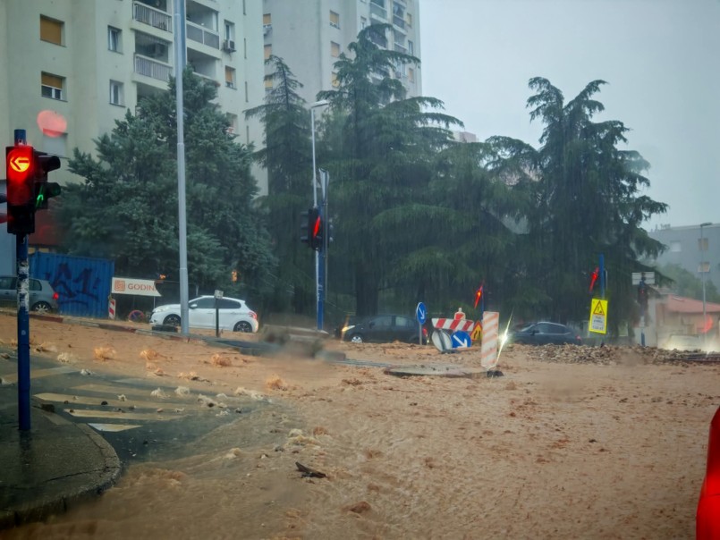
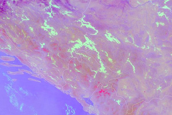
Case study about the extreme precipitation event in Rijeka, Croatia on 28 September 2022. The study focuses on the special case of convective development that caused the severe event.
This study accompanies the simulator.
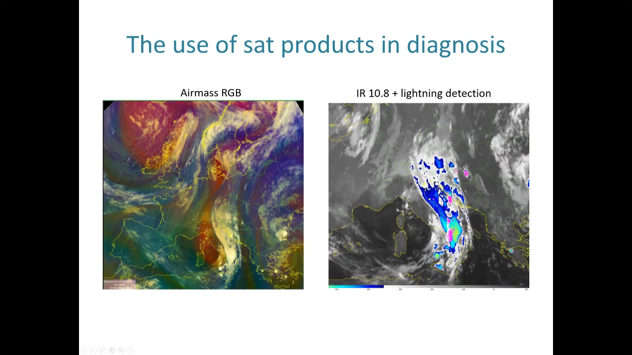
Vinko Šoljan talks about forecasting and nowcasting of deep moist convection, satellite products used, NWP outputs and more.
In this presentation, we will demonstrate the process of forecasting deep moist convection (DMC) at Croatia Control and how satellite products are utilized in this process. This includes large-scale analysis and diagnosis using satellite data, as well as monitoring and nowcasting existing DMC using satellite products and radar data. In DMC forecast we primarily rely on the ingredients-based methodology and NWP guidance.
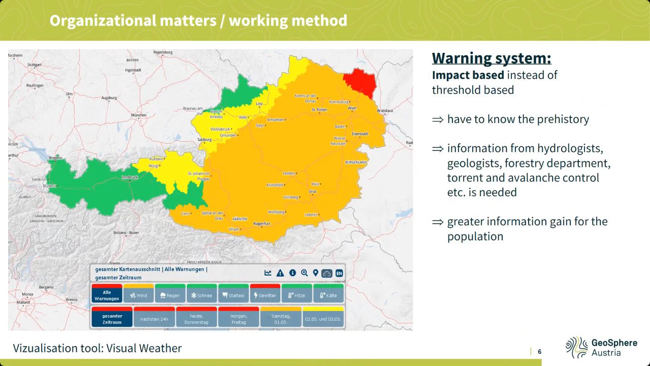
Liliane Hofer speaks about prognostic service of Austria, work organization, regional weather forecast specifics such as southerly föhn winds and others.
Various phenomena, some of which are regionally specific, such as southerly föhn winds or precipitation in northern or southern congestion, make the weather forecast in Austria very challenging at times. In addition, the topographically highly structured landscape also results in quite small-scale differences, for example in inversion weather conditions. All this and special customer products are highlighted in this presentation, as well as the basic working environment of the forecasters and, of course, the satellite products used for this purpose.
Lecture slides
Katarina Katušić talks about Croatian Met Service work principles and schedules, case study and satellite products used during operational shift work.
The Weather and Marine Analysis and Forecasting Sector is a part of the Croatian Meteorological and Hydrological Service (DHMZ), and it is in charge of weather forecasts and warnings for the public and numerous companies. Over the years, we have gone through many challenges. Quite recently, during the lockdown, the earthquake severely damaged our headquarters, and even with those difficulties the work did not stop. We also prepare and present weather forecasts for national television. Furthermore, this presentation will cover the usage of weather satellite products in daily operational work.
Lecture slides
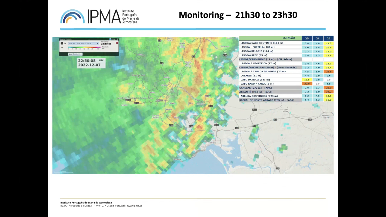
Jorge Ponte shows the challenges of being a forecaster, issuing warnings and discusses extreme precipitation event that affected Lisbon.
Extreme rainfall events in December 2022 caused significant losses in Lisbon, Portugal. This presentation examines these events to discuss whether it was possible (or not) to make a better forecast and issue earlier warnings. By analyzing various numerical model products from the preceding days alongside real-time monitoring data (satellite, radar, stations), the presentation will explore the operational forecaster's decision-making process during extreme weather situations.
Lecture slides
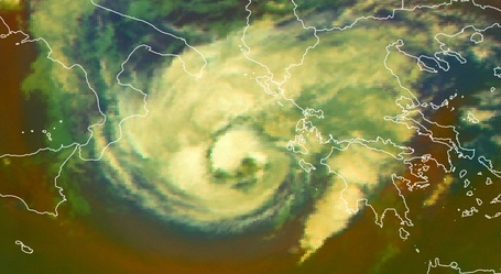
A new conceptual model on Mediterranean hurricanes - "Medicanes".
Medicanes are rare, intense and destructive warm-core cyclones occasionally generated in Mediterranean Basin.
Compared with tropical cyclones, medicanes are weaker and smaller in size, with diameters under 300 km, while the diameter of a hurricane is larger than 1000 km. Hurricanes move in general from east to west due to easterly winds, while medicanes generally (but not always) move from west to east due to the mid-latitude westerlies.
Medicanes mostly occur in the western Mediterranean and in the region extending from the Ionian Sea to the North African coast. There is strong variability from year to year without any significant trends.
Pilar Rípodas talks about the improvements that the MTG will bring in regards to NWC SAF products.
The Nowcasting SAF (NWC SAF) develops and distributes software packages to generate satellite derived products with application in nowcasting. Cloud products, precipitation products, stability product, wind product, convection products, products related to turbulence and extrapolation imagery are current products in the NWC SAF portfolio. A version of the NWC SAF software that supports the new EUMETSAT satellite MTG-I is been developed by the NWC SAF team. The first version (MTG day-1) is expected to be released early 2024. The improvements expected in the NWC SAF products in this version are presented. Some preliminary products with MTG-I data can be presented depending on the availability of data. A full exploitation of the new capabilities of MTG-I to improve the current NWC SAF products and to develop new ones will come in the following versions. The plans in this respect are presented.
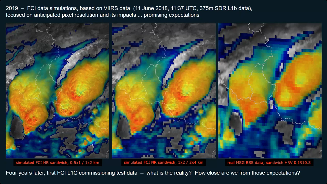
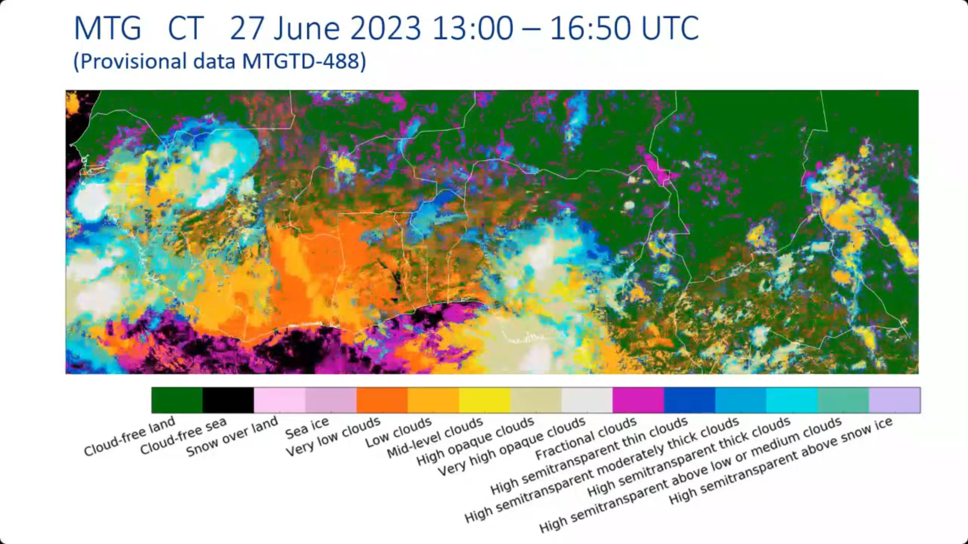
Martin Setvak demonstrates comparison between new FCI data with MSG and VIIRS, focusing on convective storms.
The presentation will address preliminary comparison of the MTG-I1 FCI imagery (based on FCI commissioning data) with MSG SEVIRI and NPP/JPSS VIIRS data, with focus on convective storms.
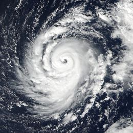
This case study describes the evolution and the life cycle of hurricanes in general and the evolution of hurricane Ophelia (2017) in particular.
This module and the adjoined simulator treat the hurricane Ophelia that threatened Europe in 2017 and hit the coast of Ireland in October that year.
In this module, you will learn more about hurricanes in general and about the evolution of Ophelia in particular from the very beginning over the Atlantic until its final stage over Ireland.
In the adjoined simulator, you will forecast the warnings related to hurricane Ophelia and the dangers that arose with this weather situation.
Vesa Nietosvaara showcases how the MTG's FCI instrument will improve the quality of satellite data, especially for users in high latitudes.
The first Meteosat Third Generation (MTG-I) satellite with Flexible Combined Instrument (FCI) was launched at the end of 2022. It will be followed later in 2024 by MTG-S Satellite with Infrared Sounder onboard. MTG will carry novelty instruments – Infrared Sounder, Lightning Imager and Ultraviolet Visible Near-infrared (UVN) Spectrometer - in the GEO orbit. Meteosat Third Generation aims to secure continuity and to increase the capabilities of the Meteosat satellites in response to requirements of the future forecast/nowcast systems. Altogether, the new and enhanced capabilities will allow us to make a huge step in better monitoring of our environment, and allowing development of new applications.