
Identify and interpret broad scale, synoptic and mesoscale systems
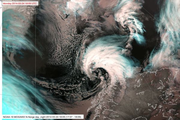
Gunnar Noer explains and showcases the nature of polar lows.
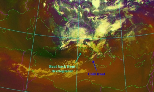
Polar lows are small but fairly intense low pressure systems that form in the Arctic marine regions during the winter season. They form in unstable air masses associated with cold air outbreaks from the Arctic ice cap. Polar Lows give rise to gale or storm force winds which, in combination with heavy snowfall, cause widespread traffic disruptions. In recent years, polar lows have caused several fatal incidents with snow avalanches. This lecture focuses on the key processes and the methodology for forecasting polar lows.
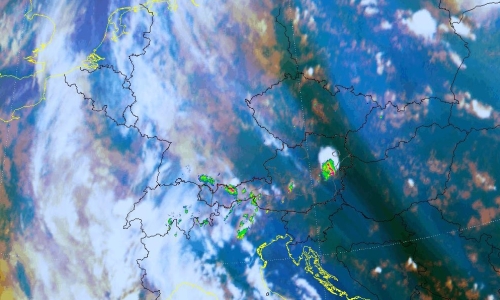
Thomas Krennert (ZAMG) talks about the importance of moisture gradients in analysing the possibility of development of deep moist convection.
The exact predictability of convection in the Alpine region in the absence of fronts in weak-surface-pressure-gradient-situations during the warm season remains challenging for forecasters. The development into single-cell deep moist convection SC-DMC under these conditions depends on the availability of well-known ingredients like low level moisture, steep tropospheric lapse rates and sufficient lift. Satellite studies have shown that favourable locations for the first onset of SC-DMC resulting from widespread shallow convection over mountainous terrain are water vapour gradients in the middle or upper troposphere UTMG (upper tropospheric moisture gradients, Krennert, et al., 2003, https://doi.org/10.1016/S0169-8095(03)00067-X). The contributions of the respective ingredients related to UTMG supporting the initiation of DMC are discussed. A focus is set on moist symmetric instability MSI as a possible mechanism for favouring the transition from shallow to deep moist convection.
Wilfried Jacobs (DWD) explains the power of Airmass RGB in estimating the possibility of cold front transforming into a convective line.
Especially, the airmass RGB is a powerful tool for estimating the cold front’s tendency to transform to a convective line. Convective lines are connected with strong gusts, heavy precipitation sometimes with graupel or even hail. During this presentation the indications of convective lines will be outlined by considering the airmass RGB together with other means, e.g., radiosounding. Examples of two succeeding days will be discussed in detail whereas the first case did not lead to a convective line whereas the second example did. Typical differences of patterns in the corresponding airmass RGB and additional data sources will be related to a convective line’s probability.
Andreas Wirth (ZAMG) presents the benefits of analysing the water vapour imagery to diagnose synoptic structures and weather patterns.
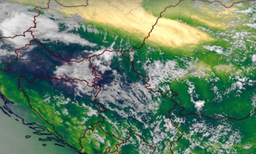
Water vapor (WV) imagery is very useful when it comes to visualize zonal and meridional transport of air masses, but it is also suited to get a rapid overview on vertical transport processes. This characteristic makes WV-imagery extremely helpful when it comes to diagnose fronts and cyclogenesis.
The presentation will focus on the dynamics of cyclogenesis and fronts and how they are reflected in WV-imagery. The concept of relative streams will be introduced in the context of cyclogenesis, ana- and kata fronts.
Meteorological products based on WV absorption bands such as the Total Precipitable Water product will be introduced and their usefulness will be demonstrated on case examples.
Christo Georgiev (NIMH) presents influence of synoptic and mesoscale dynamical process, through water vapour imagery, on the intensification of wildfires.
Studies of large fires in Australia, Tasmania, USA and Southeastern Europe have shown a link between fire activity and dry stratospheric intrusions with downward transport of energy and momentum down to the lower troposphere. In such cases the rapid increase of fire activity was accompanied by a dry band in satellite Water Vapour (WV) imagery, which is indicative of pronounced descent of upper-tropospheric or stratospheric air which is normally much dryer than the lower tropospheric one and has much higher potential vorticity. When these descending air masses, reach the Earth’s surface they affect the wind speed, moisture and ozone concentration, which could generate a spike in fire activity.
Case-study examples of such severe events over areas of Central and Eastern Mediterranean are considered in the presentation. Combination of WV imagery, satellite soundings and satellite estimations of fire radiative energy contribute to better understanding of dry stratospheric intrusion depth and related dynamical processes, which govern the intensification of wildfire occurrence and spread.
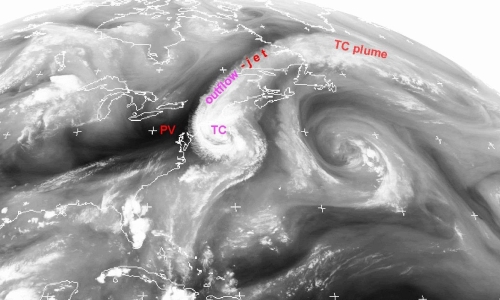
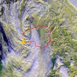
Christo Georgiev (NIMH) discusses the effect of vorticity on tropical cyclones and development of severe thunderstorms, through the scope of water vapour imagery.
Water vapour (WV) images provide useful information to anticipate the effects of upper-level dynamic environment on the intensity of a tropical cyclone (TC) as well as on its extratropical transition (ET), a gradual process in which a TC loses tropical characteristics and becomes more extratropical in nature. Analyses of WV imagery shows that during ET stage over subtropical areas, advection of potential vorticty anomaly can influence the ET and control the process.
Large amounts of water vapour, originated by TCs may be involved in transfer of moisture by planetary waves, associated with ET developments and give rise to a narrow regions of strong meridional water vapour flux. The presentation shows WV imagery synoptic-scale analysis, which shows supply with additional large amount of moisture of an existing already favourable convective environment. The
combination lead into an environment with very high CAPE and potential to accelerate upward, acquiring kinetic energy and forming strong vertical motions in a deep tropospheric layer. The process is illustrated by a case of catastrophic hailstorm over Bulgaria, Eastern Mediterranean.
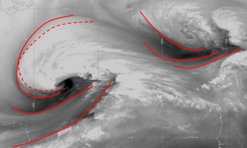
Nataša Strelec-Mahović (EUMETSAT) shows and analyses several cases of water vapour structures in the atmosphere using satellite imagery.
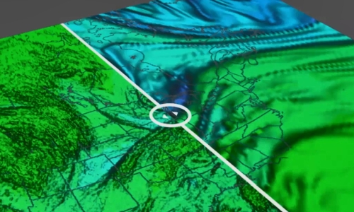
Features occurring in the WV6.2μm images indicate the processes going on in the atmosphere, since these dark (dry) and white (moist) structures result from a combination of vertical motion, moisture advection and horizontal deformation within the mid and upper troposphere. Frequently, water vapour images reveal structures such as dark stripes, mountain wave signatures, or circular or spiral formations known as water vapour eyes, eddies or vortices. We will look at how these features can be used as tracers of three-dimensional atmospheric motions on the meso- and synoptic scale and how they relate to e.g. jet-streams, upper-level lows or turbulence.
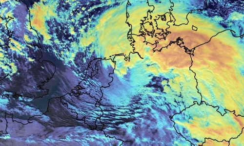
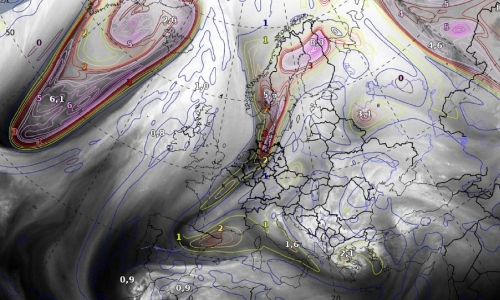
Christian Herold (DWD) investigates the usefulness of IASI L2 products in nowcasting, detecting and analyzing sting jets in rapid cyclogenesis.
Strong winds southwest of the center of a Shapiro-Keyser-Cyclone are often associated with a cold conveyor jet or a sting jet. The sting jet is a strong mesoscale flow with a very high damage potential. It is a massive challenge for NWP and forecasters to correctly predict a sting jet. The question is, can IASI profiles help forecasters for a better prediction of such mesoscale severe wind events connected with sting jets? In this specific context, some case studies will be presented.
Bryan Guarante (University of Wisconsin) uses a COMET course to explain the usefulness of analysing water vapour images with a goal of assessing the NWP fields.
In dynamically-active regions of the atmosphere, water vapour imagery approximates the same surface as the 1.5PVU height or pressure surface. Because of this, we can take advantage of the WV channels to find areas of mismatch between the NWP and the real atmosphere to adjust our synoptic scale forecasts.
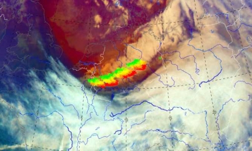
Pieter Groenemeijer (ESSL) presents his findings in using low-level moisture proxy data from polar orbiting satellites at European Severe Storms Laboratory training events.
In preparation for MTG data, ESSL is carrying out a series of expert workshops and Testbeds in collaboration with EUMETSAT. At both event types, the increased capabilities of detecting low-level moisture from geostationary orbit, which the MTG program will enable, have received a high amount of attention. In our presentation, we will discuss a number of convective storm cases that were studied using proxy data from polar-orbiting instruments, such as MODIS. One of the ways to visualize low-level moisture is by depicting the ratio of the 0.91 and 0.85 μm channels with an intuitive color scale. We will discuss to what extent this and other proxies for low-level humidity can be used to anticipate the presence of a crucial ingredient for severe deep, moist convection...
Wilfried Jacobs (DWD) introduces the water vapour channels in the 2022 EUMeTrain Water Vapour Event Week.
The target group of this presentation is participants that are not familiar or do not feel familiar enough for understanding the presentations during the entire week. The first presentation deals with basics of vapour water channels in satellite products. First, the principle of radiation and radiation transfer will be outlined briefly and put in relation to wave lengths of imagers and vertical sounders by considering weighting functions. The second part deals with some examples by using single channels. Finally, corresponding composites (RGBs) and their applications will explained in detail.
Izolda Marcinoniene gives a talk on the synoptic background for strong winds in Lithuania.
In Lithuania, very strong winds (≥28m/s) are usually caused by Atlantic cyclones. Fifty-five cases in 173 sites have been registered during the period 1961–2021. Even a few cases with very powerful winds (>40 m/s) were observed. According to statistics, most events occur during the cold season and bring significant damage. Thus, a short summary will be presented. Additionally, the typical cyclone track and synoptic situation will be shown in this presentation.