
Identify and interpret broad scale, synoptic and mesoscale systems
Javier Garcia-Pereda and Mate Mile give an overview on the NWC-SAF high resolution wind product and its application.
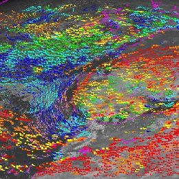
The “NWC SAF/HRW High Resolution Winds” provides a detailed calculation of Atmospheric Motion Vectors locally and in near real time. It calculates the AMVs considering cloud and humidity patterns in up to seven different MSG/SEVIRI channels (HRVIS, VIS06, VIS08, WV062, WV073, IR108, IR120), together with NWP data and the “NWC SAF Cloud products (Cloud type, Cloud top temperature and height)”.
It considers up to two tracer scales (Basic and detailed), two tracer determination methods (Gradient and tracer characteristics), two tracking methods (Euclidean distance or cross correlation), and two Height level assignment methods (Brightness temperature interpolation method and Cross correlation contribution method). As other AMV products worldwide it also includes a quality control flagging based on the Quality Indicator Method developed at EUMETSAT.
NWC SAF/HRW product can be useful in Nowcasting applications in synergy with other data available to the forecaster: monitoring of low level convergence, divergence at the top of developed systems, or other cases of small scale circulation or wind singularities. It can also be used as an input in analysis and forecasting applications like NWP models. The development and main characteristics of the product are explained with examples, useful for the potential users to know what the product can offer. The validation results related to the latest version on the product (HRW v4.0) are also explained.
The role of the Atmospheric Motion Vectors (AMV) in the modern data assimilation systems is evident nowadays. The AMVs – along with satellite observations – have an important key for our operational ALADIN data assimilation system as well. In the framework of the EUMETSAT SAF High Resolution Winds (HRW) products had been developed by AEMET for Nowcasting and Very Short Range Forecasting purposes. The HRW products provide quasi real time data of AMVs from MSG HRVIS and IR10.8 channels every hour in a day. A collaboration between AEMET and OMSZ have been focused to compare the benefit of the operationally used AMVs (received through the EumetCAST) with the newly processed HRW winds. Recent work was an extensive evaluation and monitoring of the assimilation and forecast system. The impact of the AMV winds was examined using different diagnostic techniques, verifications tools and case studies. The first results are promising regarding the use of the HRW AMV. The statistical scores on the full domain showed neutral or slightly positive impact in most of the parameters and the experiment based on HRW AMV data provided better estimate of extreme precipitation events.
David M. Schultz gives a presentation on the different conceptual models approaches concerning occlusion processes in frontal systems.
This talk presents new conceptual models in cyclone structures and evolutions. How does the large-scale flow in which the cyclone is embedded determine the type of frontal evolution that occurs? How does the air flow through cyclones, and what can this tell us about the possibility for damaging winds at the surface? This talk concludes with general principles for how forecasters can improve their skill through the use of conceptual models in operational forecasting.
Fernando Prates gives a presentation on forecasting the tracks of tropical cyclones (TC). He gives presents the TC products delivered by ECMWF.
In this module the importance of forecasting tropical cyclones (TC) is briefly discussed. An overview is given of the recent developments in the forecast systems at ECMWF with impact on the forecast of TCs, including the recent change in the model’s resolution and the implementation of the Ensemble Data Assimilation. At the present time, any TC formed in the forecast system can be identified using a tracker developed at ECMWF. How does it work and what kind of products that can be derived from it is discussed. Some examples are also presented to highlight the model's ability to forecast the genesis of TCs. Finally the statistics of the forecast performance for TCs is discussed.

Andreas Wirth gives an overview on the NWC-SAF ASII product and its applications, Eunha Sohn presents the NWC-SAF products adapted to the Korean COMS satellite.
PGE10 of the SAFNWC/MSG provides an automatic satellite image interpretation in terms of conceptual models (CMs). Conceptual models are important tools for forecasters in diagnosis, nowcasting and very short range forecasting; they describe a synthesis of typical features in satellite images as well as in other synoptic material (for instance numerical model output parameters) and the physical processes causing them. A CM diagnosis cannot only be used for detection of an ongoing process but also for the determination of the stage of development within this process.
This presentation will focus on the practical applications of ASII by showing examples of analysed synoptic weather situations.
In a second talk, Eunha Sohn from the Korean Meteorological Service will talk about applications of NWC SAF modules such as RDT, CRR, HRW and ASII in KMA, ongoing works and future works related to NWC SAF.
Frans Debie gives a presentation on the development of Rapid Cyclogenesis, their life cycle and the numerical parameters involved.
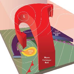
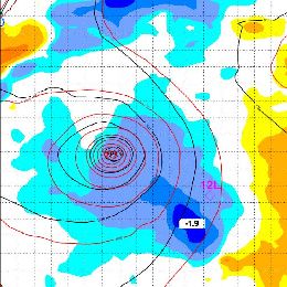
Extratropical cyclones, sometimes called mid-latitude cyclones or wave cyclones, are a group of cyclones defined as synoptic scale low pressure systems that occur in the middle latitudes and are associated with fronts (cold front, warm front and occlusion) and horizontal gradients in temperature and dew point , known as baroclinic zones. Extratropical cyclones are the everyday phenomena which, along with anticyclones, drive the weather over much of the Earth, producing anything from cloudiness and mild showers to heavy gales and thunderstorms. Evolution of these depressions can be recognized in the developing of the cloud systems. These cloud developments are the footprints of physical processes in the upper air. In case of explosive deepening it is called rapid cyclogenesis. Satellite imagery, especially recognition of cloud patterns and water vapour structures, can be a great help for marine forecasters to find the area where these cyclogenesis occurs. The deepening of the depression, where you can expect the strongest wind speeds at sea surface and what will be the distribution of the precipitation are issues which will be covered during the lecture. In general, the lecture will give insight in physical processes which can explain the development and life-cycle of rapid cyclogenesis by using single channel satellite images and RGB-images in combination with NWP model fields.
Izolda Marcinoniene presents 2 case studies on severe thunderstorms over Poland and the Baltic States.
Length: 30 minutes.
Nowcasting of severe convective storms is still one of the most challenging tasks for operational forecasters. Satellite data are very useful in convection nowcasting because they enable a detailed monitoring of the various stages of convection; from the pre-convective environment to specific features on the tops of the mature convective clouds. Also, future MTG system will provide even better tools for convection nowcasting: satellite data with better temporal (every 2.5 min) and spatial resolution.
In this lecture, severe weather cases of 29 July 2012 and 30 July 2013 will be analysed by Izolda Marcinonienė (Lithuanian LHMS), mainly using MSG satellite images and ECMWF data. The first event includes a more expanded North-Eastern European area – from Poland (where the unstable situation started) towards the Baltic States (where the severe weather phenomena developed) to Finland (where they ended). The second event hit only Lithuania, but local very heavy rain reached even the disastrous phenomenon criteria and will be shortly presented as well.
In this training module, you get an overview on the life cycle of Upper-Level-Lows and you will learn more about the impact on local weather.
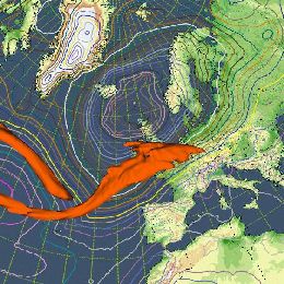
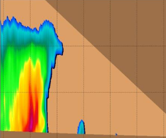
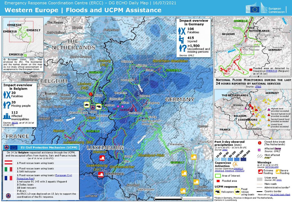
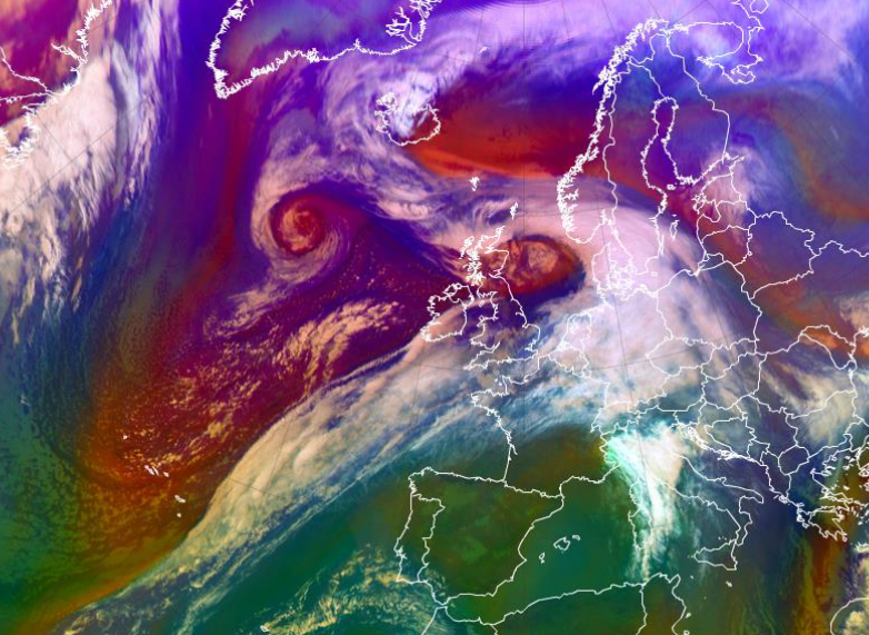
Upper-Level-Lows (ULLs) are a very common phenomenon in mid-lattitudes. They are usually associated with cold and rainy weather that can last for several days. When they remain stationary over a period of time, the can bring considerable amounts of rainfall locally. This synoptic situation has led in the past to floods and damages in infrastructure as will be show by the example of the Central European Flood in summer 2021.
This training module focusses on the meteorological aspects of ULLs, describes the life-cycle and throws a spottlight on the involved physical processes that accompany this meteorological phenomenon. Each stage of development is exemplified by satellite loops and corresponding NWP parameters. Exercises will help you to check the acquired knowledge.
Liliane Hofer highlights the properties of the Airmass RGB.
Length: 30 minutes.
The Airmass RGB is for sure one of the more complex RGB composites as it uses brightness temperature differences and not single channels on each colour beam. But - as this presentation will show - it is nevertheless a very powerful tool for discriminating between different air masses and highlighting dynamic properties of the atmosphere.
Gavin Robbins presents the meteorological conditions that led to the largest coastal surge down the East Coast of England since 1953.
Length: 30 minutes.
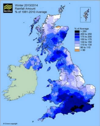
The winter of 2013-14 was the wettest for 250 years across England and Wales, with a succession of storms bringing sustained flooding from all natural sources, coastal, fluvial, surface water and groundwater. The presentation will start with an overview of the meteorological conditions that led to the largest coastal surge down the East Coast of England since 1953. The hydrometeorological conditions and flooding through late December 2013 to March 2014 will then be considered, along with examples and mechanisms of communicating the high impact conditions to emergency responders and Central Government. This included two briefings directly to our Prime Minister. Meteorological drivers and the possible teleconnections behind the exceptional conditions will also be considered.
Nuno Moreira reports on a flash flood event on Madeira in 2010.
Length: 36 minutes.
During early morning and morning on 20th February 2010 an extreme and rare flash flood event has occurred in the Portuguese island of Madeira in the North Atlantic, causing 42 casualties, 600 homeless and an estimated loss of around 1000 millions euros. In this presentation, the synoptic environment will be presented and the precipitation producing systems affecting the island will be discussed. The analysis will be mainly performed using satellite imagery from Meteosat 9, both from singles channels and RGB images, as well as from objective estimates of rain and water vapor content. Results from following studies on the precipitation regime of this mountainous island will also be presented.
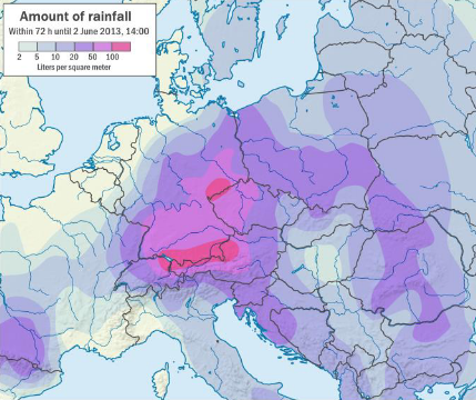
Natasa Strelec Mahovic reports on the precipitation event in spring 2014 which lead to inundations in SE Europe.
Length: 35 minutes.
From the beginning, spring 2014 was very rainy in large parts of central and south-eastern Europe. The soil was already saturated with water in the beginning of May, when mid-May a huge cyclone, persisting over Bosnia and Herzegovina, Serbia and Croatia for 3 days, caused extreme precipitation. The amounts measured in Serbia and Bosnia and along Sava river in Croatia were in some areas larger than ever measured before. Catastrophic flooding left thousands of people homeless and the consequences will be visible for a long time.
Gregory Carbin gives a presentation on the weather extremes of the winter 2014 in the US.
Length: 25 minutes.
The cool season months of 2014 (JFM) over the U.S. mainland can best be described as much colder than normal across portions of the Great Lakes, Northeast, and Midwest, and much drier and warmer than normal over the west coast, especially California. This talk offered a review of three aspects of the winter/early spring seasons. The first was a review of 12 UTC temperatures for every day in January across the continental U.S. and the relationship of some of the colder mornings with the longer-term record of January mornings back to 1979. The second event of note was the onset of exceptional drought in California. The third event, coming at the end of March, was a look at significant cyclogenesis off the U.S. eastern seaboard on March 25-26.