
Public weather service
Listed here are other resources related to Public weather service tag:
Note: click on an image to open the Resource
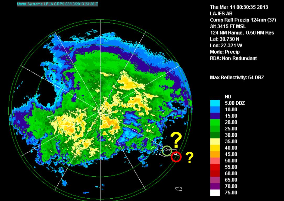
Diamantino Henriques gives a weather briefing for the Azores and looks back to the heavy rain event on 13th and 14th March 2013.
Length: 30 min
Author: Diamantino Henriques
Diamantino Henriques, received his degree in Atmospheric Physics at the University of Aveiro (1986) and his MS in Meteorology from the University of Lisboa (1996). From 1987 to 2003 he worked in Lisbon as meteorologist on atmospheric ozone and UV radiation issues. He has represented Portugal on several international meetings related with atmospheric composition and has participated in several projects and programs related with atmospheric ozone (GAW), atmospheric pollutants transport (EMEP) and UV radiation (EDUCE). In 2003 he moves to the Azores and worked at Ponta Delgada Airport as a senior meteorologist and forecaster. Later in 2008 he was nominated Head of the Regional Delegation of the Portuguese Institute of Meteorology (IM) in the Azores. Currently, he is the Head of the Azores Regional Delegation of the Portuguese Sea and Atmosphere Institute (IPMA, former IM) that includes the weather forecast service for the Azores.
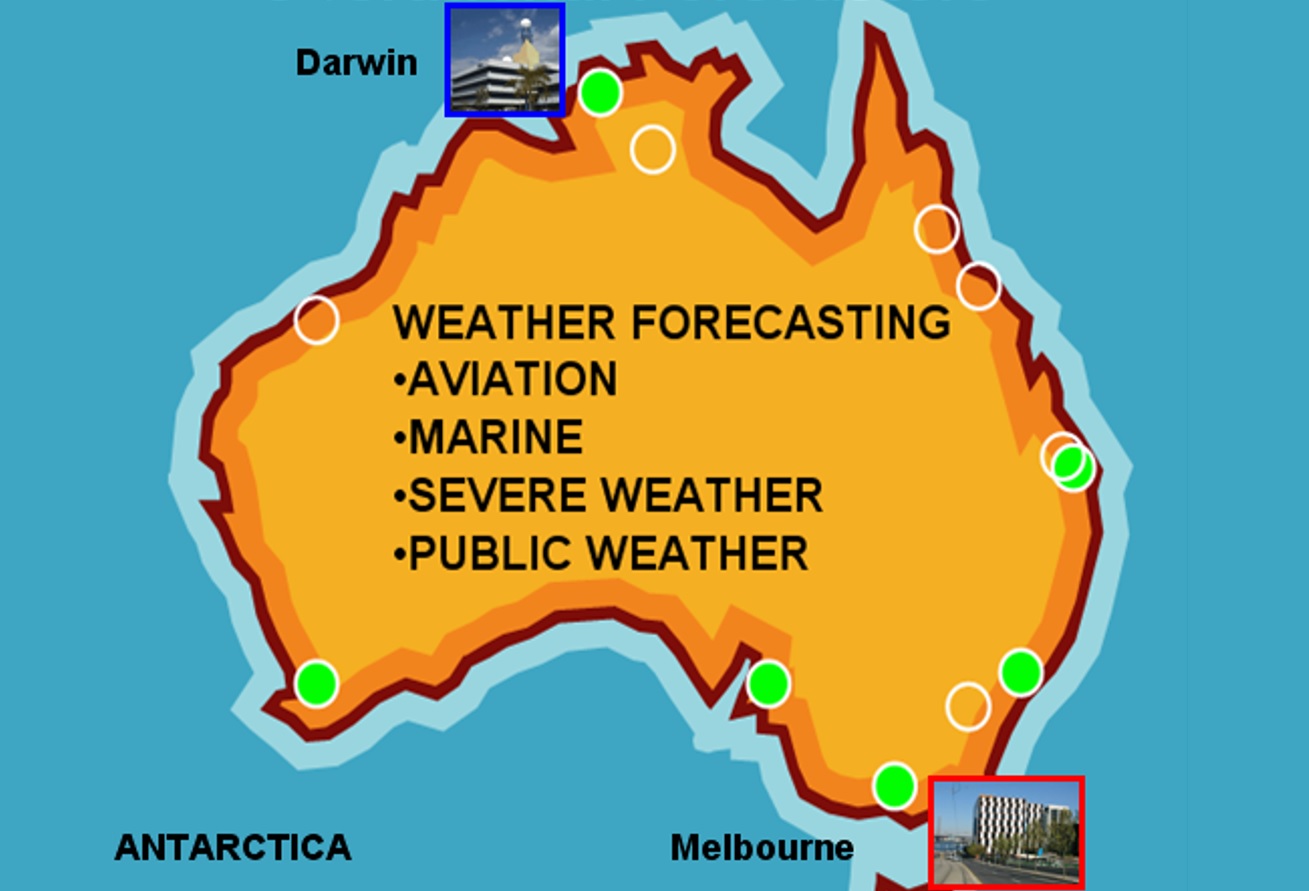
Bodo Zeschke gives a comprehensive overview of the technical facilities available at the Australian Bureau of Meteorology followed by a weather briefing and a short lecture on shallow cold fronts.
Length: 50 min
Author: Bodo Zeschke
Bodo Zeschke received his BS in Physics at the University of New South Wales and MS in Meteorology at Monash University (2001). From 2001 to 2009 he worked as a forecaster at the Darwin Regional Forecasting Centre. During this time Bodo developed an interest in fog and low cloud nowcasting and forecasting for northern Australian regions. Since 2009 he has been engaged as a Lecturer to Australian and International postgraduate students studying for the Diploma of Meteorology at the Bureau of Meteorology Training Centre. Bodo has lectured in Tropical Meteorology, Satellite Meteorology and Weather Discussion training. Duties also include presenting lectures on related topics at World Meteorology Organisation courses and at the Bureau's annual Advanced Forecaster Workshop. He is the point of contact for the Australian VLab Centre of Excellence. Present topic of interest includes the integration of the satellite multichannel RGB products generated from MODIS imagery into Bureau forecast and training resources. This in preparation for the effective use of RGB products generated by the future Himawari 8 satellite.
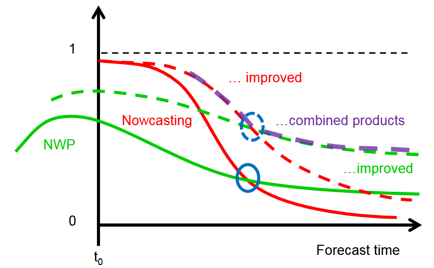
In this module the basics and advantages of Nowcasting are explained.
In this module the basics of Nowcasting in the forecast room are explained. Its practical use in the weather room is explained with a series of examples.
The second part deals with explanation and testing of Nowcasting for various situations such as convective events, frontal situations or Fog. By adding more source-material a student is taught how to improve his Nowcasting skills.
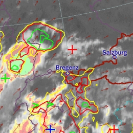
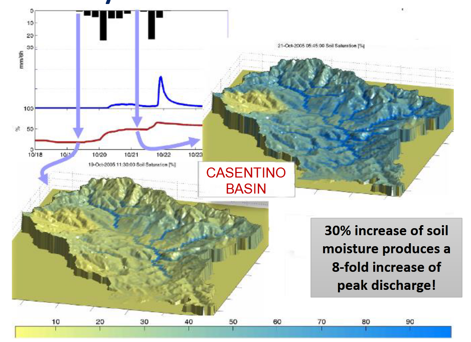
The presenters show the effects of soil moisture on future convective developments for the eastern parts of Austria.
Length: 30 minutes.
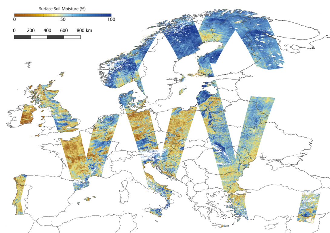
Soil moisture is supposed to be a key parameter in triggering convection as it influences the lower boundary conditions of the atmosphere and the partitioning of energy between sensible and latent heat fluxes. Using the convection-permitting numerical weather prediction model AROME, we try to quantify this impact by investigating sensitivity studies, hence estimating the potential of satellite-based soil moisture measurements to improve the forecast of convective events.
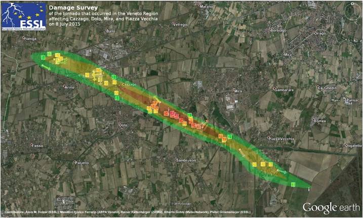
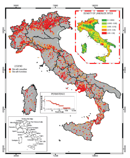
Georg Pistotnik talks about recent impact surveys, carried out by ZAMG in Austria.
Length: 36 minutes.
Windstorm and tornado intensity classification is usually done by assessing the inflicted damage, since reliable in-situ measurements are typically lacking. This presentation gives a practical introduction into windstorm and tornado damage assessment using the Fujita-(F)-Scale and the Damage Indicator (DI)-Degree of Damage (DoD) method. Recent site surveys, carried out by ZAMG in Austria, are presented and current developments towards an International Fujita-(IF)-Scale are briefly discussed.
Thomas Krennert talks about weather- and impact reports and a real-time feedback loop between forecasters and voluntary observers.
Length: 27 minutes.
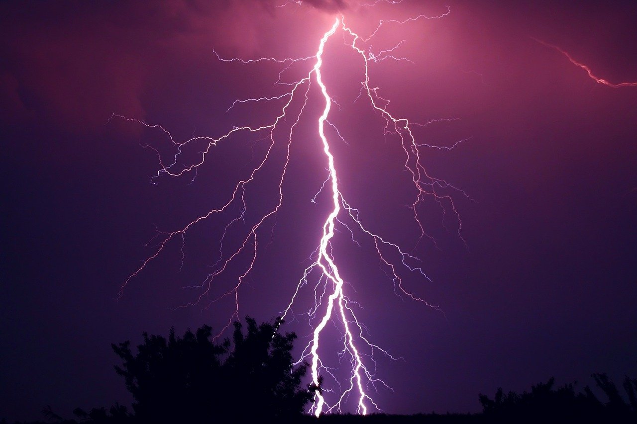
Since the release of the WMO recommendations for impact based forecasts and warnings, reliable data about weather related effects on society and public life became increasingly important for operational forecasting. Particularly densely populated urban areas are vulnerable to the forces of convective weather hazards. In this regard, operational automatic station networks or remote sensing data cannot provide complete information about the ground truth like hail size, downburst related wind damage, flash floods or damage from lightning strikes. In order to fill this gap, targeted human assessment and observations are still needed. With the help of weather- and impact reports a real-time feedback loop between forecasters and voluntary observers can be established, to improve impact based warnings and thus to increase weather related disaster resilience and mitigation. In our presentation, we introduce the Austrian weather- and impact observation system "wettermelden.at" with its applications and furthermore a concept for the swift exchange of these reports on national and European levels.
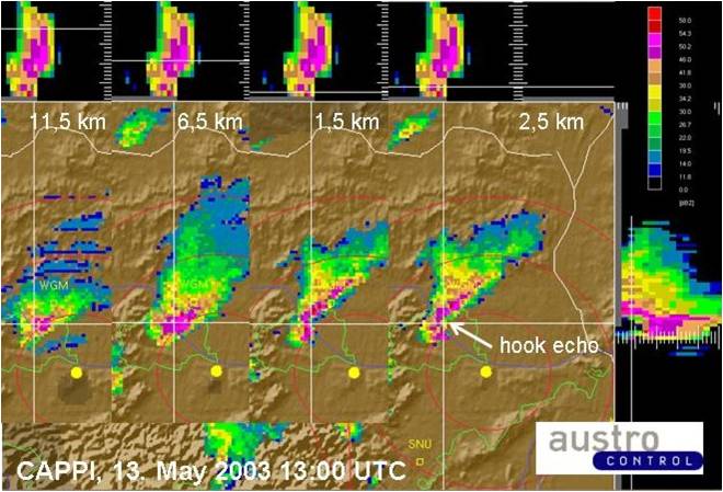
Georg Pistotnik talks about how convective cells organise to single-cells, multi-cells and super-cells.
Length: 31 minutes.
According to their degree of organization, thunderstorms can conceptually be divided into single cells, multicells and supercells. Organized storms, in particular supercells, are responsible for the large majority of severe convective weather like large hail and damaging wind gusts. They are favored by high latent instability and/or strong vertical wind shear and exhibit characteristic behavior in radar and satellite data. For nowcasting purposes and timely weather warnings, it is therefore crucial to recognize organized and severe thunderstorms in remote sensing data. This presentation focuses on key properties of this distinction and illustrates some characteristic examples.
Vera Meyer investigated the influence of synoptic flow regimes over Austria on typical thunderstorm parameters.
Length: 26 minutes.
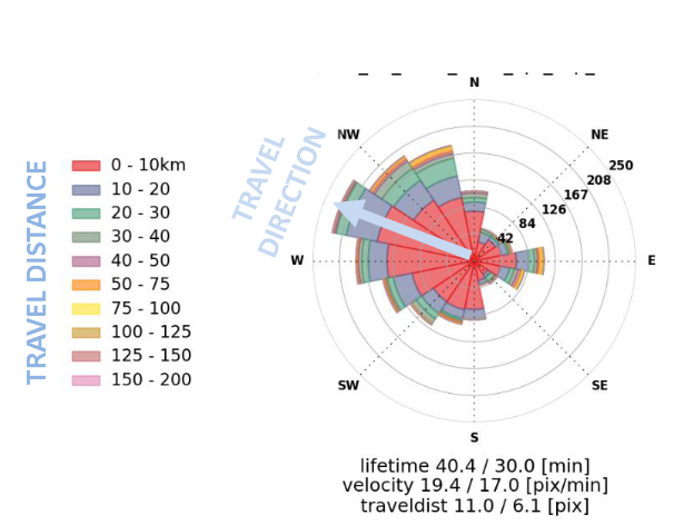
Since 2014 the Austrian thunderstorm nowcasting tool (A-TNT) monitors and nowcaststhunderstorm developments operationally based on 3D radar and lightning data. The algorithm employs an object-oriented approach observing and storing specific parameter attributes of the individual developments of convective cells. Radar data provide information about the internal precipitation structure and the probability of hail and lightning data about the electrical activity. A daily classification of the weather patterns based on a domestic development following Bissolli and Dittmann (2001) is available since 2004.
Based on a three years data sample the influence of synoptic flow regimes over Austria on typical thunderstorm parameters such as lifetime, cell size and core height, maximum and mean lightning stroke rate has been investigated as well as local thunderstorm frequencies and preferred storm paths.
Alberto de Lozar compares different cloud micro-physical schemes to better forecast thunderstorms.
Length: 25 minutes.
The goal of the SINFONY project of Deutscher Wetterdienst is to complement, refine and improve the methods of nowcasting (NWC) and numerical weather prediction (NWP) so that a continuous representation of atmospheric conditions and weather phenomena from the current time to the short-term forecast, i.e. in the period 0 to 12 hours, is possible. The pilot project focuses on summertime convective heavy-precipitation events, with the aim of providing more concise and accurate information for our warning service.
The representation of deep convection in km-scale NWP strongly depends on the parameterization of cloud processes at the microscopic scale: the cloud microphysics. Traditional NWP microphysical schemes describe each hydrometeor type (e.g. cloud water, rain, snow, graupel or ice) by one single prognostic variable. This one-moment description performs sufficiently well in many weather situations, but it is also known to produce a too coarse representation of the microphysics and dynamics of deep convective cells. Case studies have shown that a better representation can be obtained with the so-called twomoment schemes, in which each hydrometeor is represented by two prognostic variables, usually mass und number densities. Those schemes have thus the potential to produce more realistic convective dynamics, which can improve short-term forecasts of heavy-precipitation events
We employ different observational systems to evaluate how different models and microphysical parameterizations represent clouds and precipitation over Germany. We compare simulations with ICON and COSMO using different microphysical schemes (operational one-moment vs. Seifert and Beheng two-moment). All simulations are driven by the same boundary conditions from the ICON-EU analysis fields. The simulated period is spring/summer 2016, which is characterized by heavy convection over Germany. In the presentation we mainly focus on the observations from the radar network and on the observations in the visible channels from SEVIRI.
Stefania Camica and Lucca Brocca describe the theoretical background for using satellite SM products in flood prediction.
Length: 19+24 minutes.
Satellite soil moisture (SM) products have been largely used for flood prediction. The knowledge of initial soil moisture conditions before a rainfall event is critical to determine the magnitude of a flood event. The presentation will describe the theoretical background for using satellite SM products in flood prediction, and will show examples for understanding the critical role of initial soil moisture for predicting floods.
Silvia Puca presents how satellite products impact the efficiency of hydro-meteorological warning.
Length: 28 minutes.
Many severe meteorological events occurred in Europe during the last decade and caused casualties and damages to the historical heritage and natural environment. Protection of civilians and safeguard of the territory are the kay mandates of a civil Protection (CP) agency. This is achieved through activities that mitigate hydro-meteorological risks, such as flooding and droughts. European CP agencies, supported by meteorological and hydrological institutes, aim to assess risk scenarios, to monitor and supervise events and risk levels, providing early warning to National and local authorities.
Near real time accurate estimations of hydrological variables such as precipitation and soil moisture are invaluable to the CP agencies, enable them to issue early warnings and plan for disaster relief at the local level.
Besides measurements of key hydrological variables by ground-based instruments, often affected by a limited spatial coverage, advanced satellite-based precipitation and soil moisture products developed within different international programs as H SAF, are available and accessible to users in near-real time.
In this study, recent severe meteorological events are selected in order to understand how the main satellite product characteristics, i.e. accuracy, spatial pattern and resolution, update frequency and latency, impact the efficiency of a hydro-meteorological early warning system at a local level in an operational framework.
Andreas Frank gives a short overview about ZAMG special products for winter road conditions.
Length: 26 minutes.
During winter season we have a lot of additional products dealing with road weather, especially road conditions (snow, ice, hoarfrost,...). The talk will give a short overview about our special products, what are the differences to a normal forecast and point out some problems in forecasting special parameters in the alpine region. Additionally you will get some information about our special training services for road maintainance workers and also you will get a short overview about our internet portal, which we provide for our customers.