
Weather
The purpose of the lecture is to provide a necessarily brief overview of the basic physical principles underlying satellite precipitation estimation methods.
The estimation of precipitation from space was attempted almost at the beginning of the satellite meteorology era by establishing a somewhat loose link between visible and infrared imagery of cloud tops and precipitation intensity at the ground. Since the early days estimation methods have qualitatively and quantitatively evolved with the advent of passive microwave sensors first and precipitation and cloud radars more recently. The purpose of the lecture is to provide a necessarily brief overview of the basic physical principles underlying satellite precipitation estimation methods trying to make the audience aware of what the sensors actually “measure” (radiation properties) and how these measurements are converted into precipitation intensity. All the methods, either based on “passive” or “active” sensing, are necessarily indirect and thus a clear understanding of the physics of radiation and of cloud hydrometeors is needed for the correct use of the products. In fact, such understanding helps in identifying the limitations of the existing precipitation products, which are too often used improperly or taken for granted. The lecture will try to pave the way to the in depth lectures of the other instructors on more specific topics of the discipline.
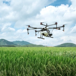
Norman Wildmann presents a wind measurement technique based on the use of UAS, a.k.a. drones.
Exchange and transport processes in the ABL are driven by turbulence on a wide range of scales. Their adequate parameterization in numerical models is essential. In heterogenous and complex terrain, the common simplification of turbulence to statistical models does not necessarily hold. Coherent structures such as convective cells, gusts, slope and valley flows, but also turbulence in cities or behind wind turbines are features which are not well represented in models. A reason for the lack of understanding is the challenge to adequately sample their spatio-temporal structure. Small unmanned aerial systems (UAS, a.k.a. drones) are increasingly used to measure meteorological quantities, including the three-dimensional wind vector in the ABL. In this talk, methods and results will be shown how UAS, either fixed-wing or rotary-wing, can be used to obtain in-situ measurements and thus help to understand complex flows.

Ab Maas talks about the challenges that wind presents in ballooning.
Although balloons were by far the first manned aircrafts in the sky their economic and military importance stayed marginal.
The main reason for that is the difficulty of steering a balloon. Balloons go with the wind flow and the only way to steer a balloon is to find different wind directions at different heights. Therefore, wind and wind forecasts are of utmost importance for sport- and commercial ballooning.
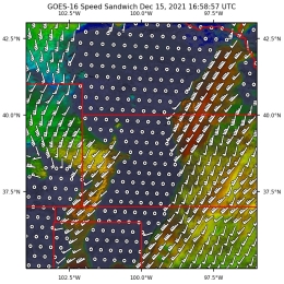
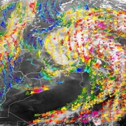
Jason Apke presents a method to derive winds from satellite data and shows some example applications.
The new Geostationary Operational Environmental Satellite (GOES)-R Series Advanced Baseline Imager and similar instruments represent a substantial improvement in the spatial, spectral, temporal, and radiometric resolution of operational space-based imagery for atmospheric sciences. The enhanced resolutions enable the objective derivation of fine-scale brightness motion, or so-called "optical flow" (OF), over a variety of meteorological phenomena with techniques that address the weaknesses of current generation cloud and feature tracking algorithms. The techniques even allow for precise dense OF derivation, or motion retrieval at every image pixel, which has a variety of applications that will be invaluable to satellite remote sensing-based forecasting and research in the future. These applications include Atmospheric Motion Vector fields, temporal brightness interpolation, feature extrapolation, image stereoscopy, and semi-Lagrangian brightness temperature field derivation. As motion is an observable that provides unique context on features observed with an image, OF fields further offer significant new predictors to a variety of objective machine learning and decision-making tools now in development. This presentation will go into detail on how some of these new dense OF techniques are derived and highlight efforts to produce and validate new products. Demonstrations of novel RGBs and their uses for operational forecasting will be overviewed, such as blends of derived speed for inferring shear and cloud-top cooling for inferring vertical growth with clouds in visible satellite imagery. Efforts to validate wind products will also be shown which highlight the strengths and weaknesses of dense OF derivation for satellite remote sensing purposes. Examples of future applications and research will also be covered, including a look into the future of OF derivation with an example 6-sec GOES-17 dataset.
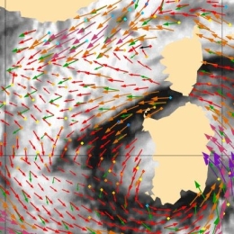
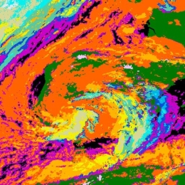
HansPeter Roesli illustrated the impact of wind on clouds by examples taken from satellite imagery.
Vertical and horizontal winds in a moist airmass may generate characteristic cloud patterns. Vice versa specific cloud patterns expose the wind fields behind the scene. The talk illustrates this interplay with imagery from data of operational sun-synchronous and geo-synchronous imaging satellites. It shows cases like gravity waves, undular bores, haboobs, ship tracks or stack plumes.
Ad Stöffelen provides an overview on current wind products and services.
Never before so many ocean wind sensing satellites were available for application in meteorology, oceanography and climate. These satellite ocean winds are continually improved in quality and service. An overview will be provided of the current products and services, with particular focus on their earth coverage, timeliness, quality and on coastal and extreme winds. Furthermore, relevant aspects for application in nowcasting, ocean forcing, climate and NWP data assimilation will be highlighted.

Valerie-Marie Kumer tals about the challenges of flying in complex terrain.
Flying in complex terrain is challenging as orographic induced turbulence can lead to unexpected loss of aircraft controls. In order to keep aircraft operations as long as possible actable and safe a skilled turbulence forecast is of vital importance. Since turbulence forecasts are highly dependent on model resolution and parameterization schemes, they do not always hit the scores. With the knowledge of general fluid dynamics and observations regions and onset of hazardous conditions can be specified. Let us explore what we can look at to improve our turbulence forecasting skill.
Roland Winkler talks about the safety and economic impact of wind in aviation.
Despite ever-advancing technology and automation, weather continues to have a major impact on aviation. Weather forecasts in aviation have two important functions. They support safety on the one hand and economic efficiency on the other. As part of this presentation, I would like to take a closer look at the complex subject area that the wind exerts on the approach and departure.
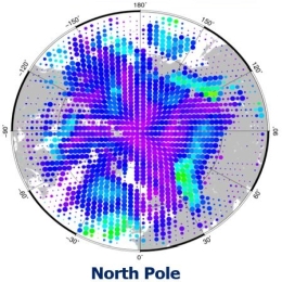
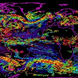
Régis Borde gives an overview on the actual wind products extracted from polar satellites over the world.
Derivation of wind products from polar orbiting satellites has been developed in the 2000’s to populate the high latitude regions where no observation could be obtained from geostationary satellites. Taking advantage of a wider variety of instruments available at Low Earth Orbit, several types of wind information are now produced operationally, and not limited to Polar Regions anymore.
This presentation will give an overview of the actual wind products extracted from polar satellites over the world, and then focus on the EUMETSAT activities which includes the operational production from imagers, the recent development of 3D winds from Hyperspectral instruments, and the preparation of the future Doppler Wind Lidar mission.
Polly Schmederer presents an evaluation of the EXIM product.
With the latest version of EXIM, new NWCSAF products were added to the list of sub-products and a new extrapolation feature, the so-called CTTH filter, was introduced. The CTTH filter allows extrapolating pixels using atmospheric motion vectors (AMVs) stemming from the same userdefined layer. This talk presents the value gained by extrapolating the new sub-products with EXIM and the impact CTTH-filter has on the extrapolation of the various sub-products.
Alexander Jann presents the NWC SAF product EXIM, its functionalities and the algorithm.
Extrapolated Imagery (EXIM) is one of EUMETSAT's NWCSAF/GEO products. EXIM kinematically extrapolates satellite imagery and selected NWCSAF products by up to a lead time of 1 hour.
The software developer gives an overview over EXIM's functionalities, the algorithm, challenges faced, and recent developments introduced in the latest version, which is currently under review for being released.
Javier Garcia Pereida presents the NWC SAF product High Resolution Winds and shows application examples.
The NWCSAF/HRW-High Resolution Winds product provides a detailed calculation of Atmospheric Motion Vectors and Trajectories locally and in real time by its users. In this moment, it is able to do this in all regions of the Earth with 5 MSG/Himawari/GOES-R geostationary satellites and 12 NOAA/SNPP/Metop/EOS polar satellites (inside NWC/GEO v2021 and NWC/PPS v2021 software packages).
It is useful in Nowcasting applications, for watch and warning of dangerous wind situations, and monitoring of the general atmospheric flow, small scale circulation and wind singularities. It can also be assimilated in NWP Models and Climate applications, with special interest in its global applicability. In this session, examples will be provided considering all these possibilities.