
Climate
Emilio Chuvieco presents data sets and products generated by the ESA FireCCI programme.
The presentation is about the set of burned area products derived from the European Space Agency's Climate Change Programme. They include a Sentinel-3 SYN global product, generated from 2019 until present, at 300 m resolution; a Terra-MODIS-based 250 m product generated from 2001 to 2022, and a high-resolution global mosaic based on Sentinel-2 MSI images for 2023. All products have been statistically validated using higher resolution images and are used for different applications, including fire emissions and the impact of burning on tropical deforestation.
Carlos da Camara addresses the application of remote sensing for the development of an early warning system for fire danger.
In recent years, Europe has been affected by severe wildfires that are driven by vegetation stress and fire weather, and have severe impacts at social, economic and ecological levels. To assist fire managers and firefighters, the LSA SAF has developed an early warning fire danger system for Europe. The system relies on a set of regional models that provide forecasts of local meteorological fire danger based on statistical models of fire radiative power that use the so-called Fire Weather Index as a covariate. The rationale will be described in detail, and several case studies will be presented.
Célia Gouveia talks about LSA SAF vegetation data used for fire assessments and monitoring.
Fire-prone conditions and the impact of wildfires on vegetation dynamics and productivity are analysed using the land surface temperature (LST) and evaporatranspiration (ET and ETREF) and their impacts on vegetation and products such as Fraction of Absorbed Photosynthetically Active Radiation (FAPAR), Fraction of Vegetation Cover (FVC) and Gross Primary Production (GPP) disseminated by LSA SAF.
Have you ever wondered what an Atmospheric River is or how to recognize it in model or satellite data? The freshly released training module will assist you by guiding you step by step through the identification process.
First you will learn some basic facts on Atmospheric Rivers; how and where they are created, their typical characteristics and their appearance in satellite and model data. Step by step, you will then be guided through the identification process until you are certain that you are dealing with the phenomenon that is called an Atmospheric River.
Later stages of Atmospheric Rivers are sometimes tricky to identify as they are often merged with mid-latitude frontal systems. But here again, model fields and the timely evolution can give a precise answer whether there is an embedded AR or not.
And finally, it is well invested time going through this training module as ARs are responsible for many floods and heavy precipitation in Western Europe once they make a landfall.
The purpose of this Training Module is to provide step-by-step instructions for identifying Atmospheric Rivers.
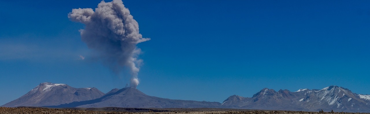
Training module focusing on identification of volcanic ash and sulfur dioxide plumes from satellite imagery.
Volcanic eruptions have a severe impact on human health, economy and traffic. They regularly cause natural disasters such as tsunamis and lava flows that are difficult to predict. Volcanic eruptions emit large amounts of gases, ash, and other aerosol particles into the atmosphere. In the short term, volcanic ash plumes have serious impacts on aviation. It is, therefore, very important to monitor the extent, height and duration of such events to properly estimate the impact of eruptions at various spatial and temporal scales, using data from different instruments on different satellites.
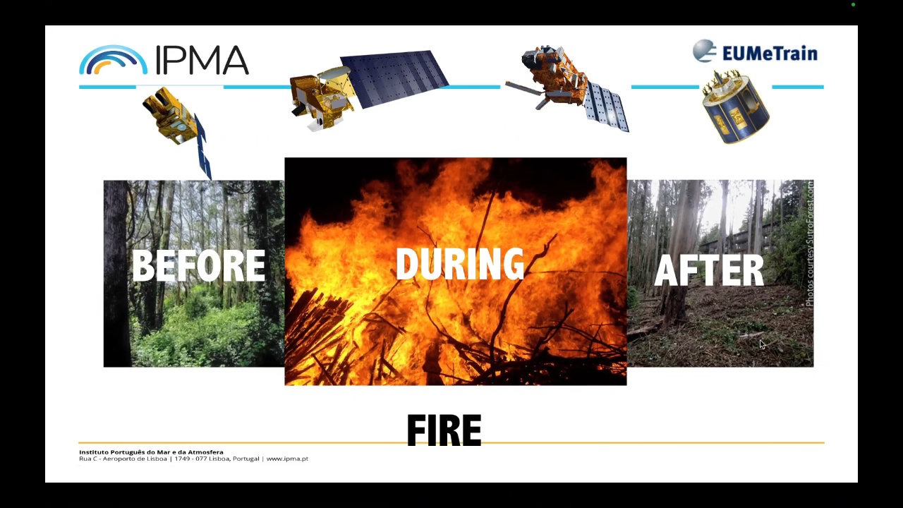
Celia Gouveia shows the importance of monitoring the fire risk for preventive measures, as well as impact assessment.
LSA-SAF generates a large set of products for land surface characterization derived from SEVIRI on board Meteosat Second Generation (MSG). The availability of such datasets in Near Real Time (NRT) allows a continuous monitoring of the situation before, during and after wildfire. The monitoring of the situation during the fire season relies on the fire risk mask (FRM) disseminated daily and with 5 days in advance. The severity of the occurred events is assessed by means of Fire Radiative Power. Post fire conditions over burned areas and the assessment of the impact of fire events on vegetation regeneration is assessed by means vegetation products.
Lecture slides
Federico Fierli shows how to use satellite imagery for observing aerosol.
Aerosol particles are a key component of weather and climate atmospheric system. Satellite offer the unique advantage to provide a global view with a long-term continuity. We will explore the methods to retrieve aerosol burden with the associated uncertainties for several cases as dust plumes and wildfire emissions. The presentation addresses the data chain from retrieval using different orbital geometries, spectral regions and geophysical products to advanced products as Climate Data Records to the assimilation process.
Lecture slides
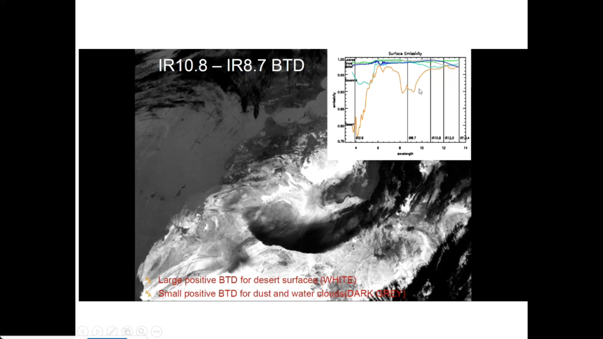
Learn how to detect areas covered with snow, ice or cloudy areas.
In this module you will be able to identify geographical features and surface characteristics and conditions through images and satellite products. Although surface features are not the main purpose of meteorological forecasting, being able to identify and distinguish them from atmospheric features can be useful.
To access the resource click here.
Learn how to identify hotspots.
In this module you will be able to identify geographical features and surface characteristics and conditions through images and satellite products. Although surface features are not the main purpose of meteorological forecasting, being able to identify and distinguish them from atmospheric features can be useful.
To access the resource click here.
Learn how to identify areas of drought and heatwaves.
In this module you will be able to identify geographical features and surface characteristics and conditions through images and satellite products. Although surface features are not the main purpose of meteorological forecasting, being able to identify and distinguish them from atmospheric features can be useful.
To access the resource click here.
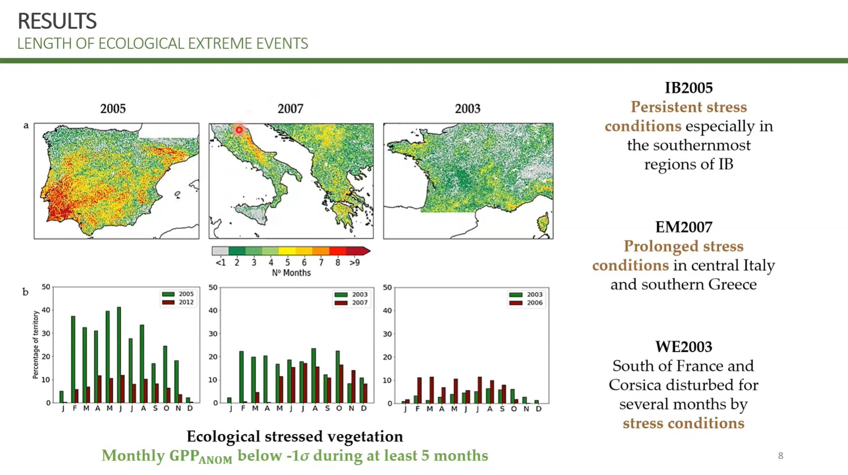
Tiago Ermitão covers practical application of studying impacts of heatwaves and droughts on the carbon cycle, namely vegetation productivity losses.
Droughts and heatwaves have become more frequent and severe over the last years as a consequence of climate change. These events result in water stress conditions to vegetation, affecting photosynthesis and respiration from plant to ecosystem scales, impacting the net carbon balance of ecosystems. This lecture will provide insights on the impacts of climate extreme events on vegetation function and the carbon cycle, showcasing examples on how these impacts can be detected using remote sensing products how Earth System and other models can be used to project future impacts of extreme events on the Carbon cycle.
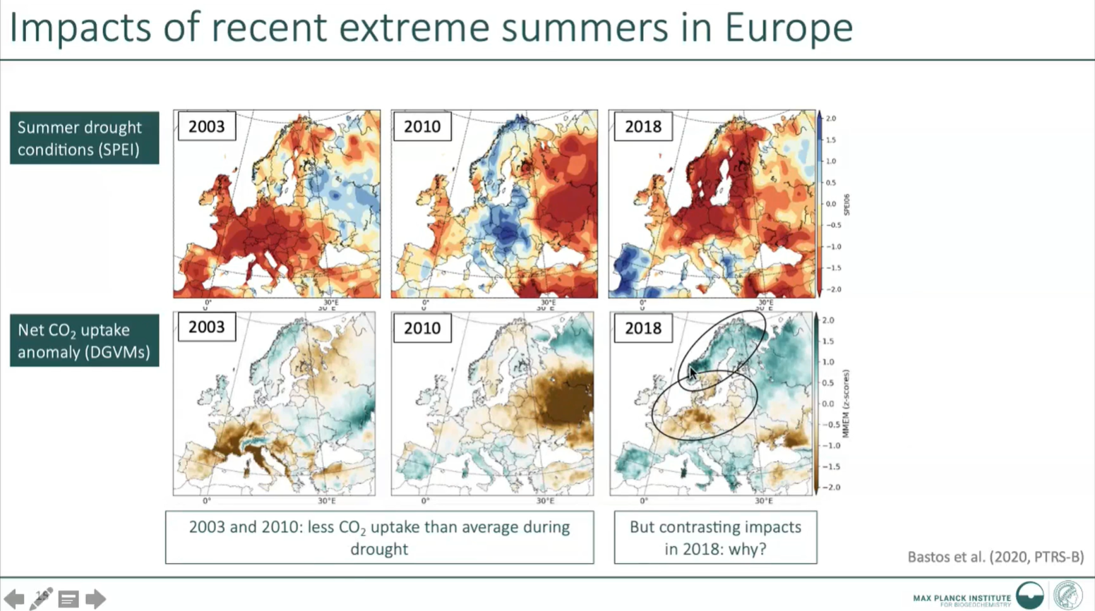
Ana Bastos presents about extreme climate event impact on carbon cycle and vegetation.
Droughts and heatwaves have become more frequent and severe over the last years as a consequence of climate change. These events result in water stress conditions to vegetation, affecting photosynthesis and respiration from plant to ecosystem scales, impacting the net carbon balance of ecosystems. This lecture will provide insights on the impacts of climate extreme events on vegetation function and the carbon cycle, showcasing examples on how these impacts can be detected using remote sensing products how Earth System and other models can be used to project future impacts of extreme events on the Carbon cycle.