
Weather
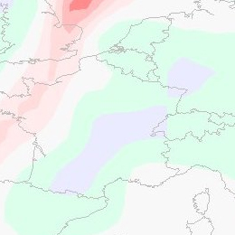
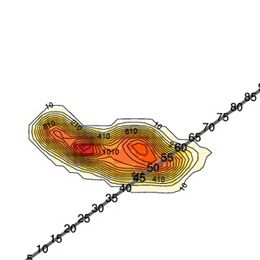
On September 12th 2010 a major PV anomaly, in the rear of a cold front, moved over France and hit Germany and Switzerland in the late evening and also Austria during the night. On the front side of this anomaly convective cells developed and brought some rain showers and thunderstorms.
On September 12th 2010 a major PV anomaly, in the rear of a cold front, moved over France and hit Germany and Switzerland in the late evening and also Austria during the night. On the front side of this anomaly convective cells developed and brought some rain showers and thunderstorms. At first the ECMWF-model, especially the 00 UTC run from September 12th, was lacking performance shifted the PV maximum more westward. In this case study we analyse not only the synoptic situation, but also the model error. In the following we take a look at the MPEF (Meteosat Product Extraction Facility) Divergence product, how it works and whether it would have been helpful in this case as a nowcasting tool.
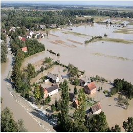
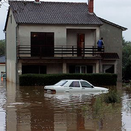
This case study will present the circumstances and explain the processes that led to severe flooding in both Slovenia and Croatia in September 2010.
Last days of summer 2010, Slovenia and Croatia were marked by heavy rainfall and floods. The precipitation amounts in some parts of Slovenia was exceeding all recorded rainfall amounts in the last 100 years causing immense property damage and even human casualties. In the western part of Slovenia locally more then 500 mm of rain fell in 48 hours. Huge part of Slovenian territory was flooded, which included also more than 8200 houses.
The amount of rain in Croatia was not so great. In Gorski Kotar region (mountain area in the western part of Croatia) and in Istria in three days 200 to 300 mm of rain was reported causing mostly flash floods. The main problem in Croatia was the water that was brought by Sava river from Alpine region. Because of the instantaneous unit hydrograph the southern part of Zagreb was flooded for several days.
Even though the prognostic material was giving the clear sign of a probability of heavy rain and the warnings were issued several days in advance, the amount of precipitation was so big that the damage was not possible to avoid.
This case study explains the processes that led to severe flooding and specialty of this study is that it brings and introduces H-SAF as a tool for detail monitoring which is of great help to the meteorological and hydrological specialists during and after the event. In this case study products of H-SAF are explained and some samples are presented.
During the night from 24 to 25 September 2010 heavy rain caused flash-flooding of the town of Pula and the surrounding area.
The case study shows that the flash floods in Pula were the result of a convective system which developed in the convergence zone caused by a specific placing of two Mediterranean cyclones. Generally, the Mediterranean region is recognized as one of the most cyclogenetic regions in the world. Mediterranean cyclones are classified in 3 major types: Genoa cyclones, Adriatic cyclones and non-Genoa cyclones. Although it is rather rare, the major-type cyclones can exist simultaneously belonging to the theoretical category of twin or eyeglass cyclones. The most common twins are the simultaneous Genoa and Adriatic cyclones (Brzovic, 1999), therefore classified as the 4th type of Mediterranean cyclones. Depending of the season and general synoptic conditions, the paths of the cyclones in the Mediterranean basin are diverse. On their way through this complex geography, they can produce a range of extreme weather phenomena such as heavy orographic precipitation, thunderstorms, supercells and mesoscale convective systems.
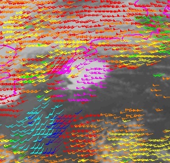
At 18 August 2011 a severe thunderstorm system developed over Belgium. This case study investigates the synoptic situation in which the windstorm developed using satellite, radar, NWP fields and lightning data.
On 18 August 2011 a severe thunderstorm system developed over Belgium. It initiated over France and then passed over Belgium, the Netherlands and Germany. The studied thunderstorm grew fast and was long-lived. It was extremely severe; particularly the downdraft was extremely strong. The most intense part of the windstorm hit the Pukkelpop festival organized close to the city of Hasselt. There were 60 thousand people at the festival, staying mainly at the camping site. The strong wind flattened tents, uprooted trees, brought down festival light towers and TV screens, and caused a stage to collapse. Five people were killed and 140 people injured in the storm, ten of them seriously. The aim of this case study is to describe the synoptic situation in which the windstorm was initiated and developed, and to describe its characteristics by means of satellite, radar and lightning data and numerical simulation.
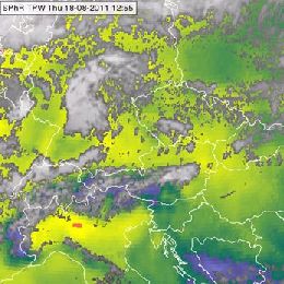
This case study presents an analysis of radiation fog event over the Pannonian Basin that took place from 18th to 20th November, 2011.
This case study presents an analysis of radiation in a fog event over the Pannonian Basin that took place from 18th to 20th November, 2011. It is an example of the conceptual model of fog and stratus cloudiness. Special attention is dedicated to the analysis of vertical atmospheric profiles (temperature, humidity and wind) combined with satellite observation.
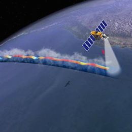
This case study demonstrates the usability of wave height altimetry data from Jason-2.
This case study treats a storm over the Atlantic which started its development on 14 April 2012 and lasted until 17 April. The deepening depression and associated strong surface winds gave birth to high waves and sea swell affecting the northern Spanish coasts. The case study focuses on sea level altimetry data provided by Jason-2. A comparison with ECMWF wave model (WAM) is undertaken.
The aim of the case study is to show the quality of Jason-2 data in comparison with model data and in situ measurements.
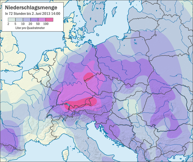
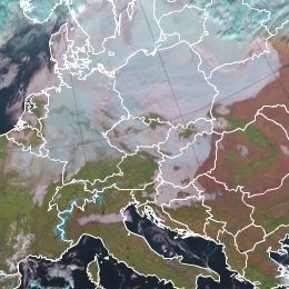
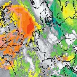
This case study is analysing floods that occurred in central Europe during the period of June 2013.
The case study is analyzing floods in central Europe during the period of June 2013. The case starts with the development of a trough over central Europe on 22 May, seven days before the floods. From 29 May on, the trough intensified the rainy weather, causing southern and southeastern Germany to experience continuous rain over several days. Altogether the countries of Germany, Poland, Czech Republic and Austria were seriously affected by floods and the damages in Bavaria (Germany) only were estimated to 1.3 billion euros.
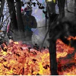
From 20 August to 2 September 2013 the Caramulo Mountains in central Portugal experienced a series of three large and devastating forest fire events.
From 20 August to 2 September 2013 the Caramulo Mountains in central Portugal experienced a series of three large and devastating forest fire events that caused a total burned area of about 9415.5 ha and 6 casualties. The Caramulo fires had overwhelming ecological, social and economic consequences that will be felt for several years. They were the result of a complex combination of variables from human factors to adverse meteorological and topographic conditions. This case study will address these variables of the Caramulo fires, which lead to environmental disaster.
The case study treats a series of wildfire that rage across Madeira Island.
In early August 2016, a series of wildfires raged across Madeira Island, in the North Atlantic Ocean, prompting the evacuation of more than one thousand people, destroying about 105 homes as well as a five-star hotel in Funchal, the main city in Madeira, and causing the death of 4 people. Flights at Madeira airport were disrupted due to the smoke. The fires caused ca. 60 million euros in losses. An area of ca. 3000 hectares was burned. This case study investigates the synoptic background that lead to this natural disaster.

Wecast of the SMHI online workshop on technical aspects of the PPS v2014 software package.
The EUMETSAT SAF to support Nowcasting (NWCSAF) develops two software packages, one for geostationary imagery and one for polar satellite imagery. Both packages retrieve cloud and other parameters relevant for nowcasting and other applications relying on cloud detection. For more information see www.nwcsaf.org
The Polar Platform System (PPS) software package retrieves information on clouds and precipitation from NOAA satellites, MetOp and S-NPP. The recent release of PPS v2014 features also a number of technical updates affecting installation of PPS and interfacing to your environment and applications.
The workshop is addressed to users of PPS wanting to update their application, but also to prospective new users.
The NWCSAF kindly invites you to participate to a two hour online training workshop on the installation, use and operation of the new PPS v2014 software. We plan to have appoximately four half-hour slots around the following subjects:
* Installation
* New output format
* Operating PPS via the main script "RunAllParallel.py"
* Setup PPS in a real-time environment (no Task Manager in v2014)
Presentations (PDF):
PPS v2014 Engineering Introduction
PPS v2014 Binary Distribuitions
PPS v2014 Running in Real-time
In this module, we will introduce the concept of Total Precipitable Water (TPW) and show how satellite-based products help in estimating the amount of water vapour in the atmosphere.
In this module, we will introduce the concept of "Total Precipitable Water" (TPW) and show how satellite-based products help in estimating the amount of water vapour in the atmosphere. The module starts with an overview on measuring principles and algorithms on how to retrieve the water vapour content of the atmosphere. In the second chapter, you will learn more about the different TPW products from geostationary and polar orbiting satellites. Finally you will see some practical applications of TPW products in nowcasting precipitation events.
Go to the Product Tutorial ...
The purpose of this tutorial is to help the reader understand and use the SEVIRI Physical Retrieval (SPhR) product of the EUMETSAT Nowcasting SAF.
The purpose of this tutorial is to help the reader understand and use the SEVIRI Physical Retrieval (SPhR) product. SPhR's purpose is to provide information on convective environmental parameters, particularly on moisture content and atmospheric instability. These parameters are crucial in studying the potential for deep convection, and in predicting the development of convective clouds. Moisture, instability and a lifting (trigger) mechanism are needed for the formation of deep convection.