
Identify and interpret atmospheric phenomena

Ab Maas talks about the challenges that wind presents in ballooning.
Although balloons were by far the first manned aircrafts in the sky their economic and military importance stayed marginal.
The main reason for that is the difficulty of steering a balloon. Balloons go with the wind flow and the only way to steer a balloon is to find different wind directions at different heights. Therefore, wind and wind forecasts are of utmost importance for sport- and commercial ballooning.

HansPeter Roesli illustrated the impact of wind on clouds by examples taken from satellite imagery.
Vertical and horizontal winds in a moist airmass may generate characteristic cloud patterns. Vice versa specific cloud patterns expose the wind fields behind the scene. The talk illustrates this interplay with imagery from data of operational sun-synchronous and geo-synchronous imaging satellites. It shows cases like gravity waves, undular bores, haboobs, ship tracks or stack plumes.

Valerie-Marie Kumer tals about the challenges of flying in complex terrain.
Flying in complex terrain is challenging as orographic induced turbulence can lead to unexpected loss of aircraft controls. In order to keep aircraft operations as long as possible actable and safe a skilled turbulence forecast is of vital importance. Since turbulence forecasts are highly dependent on model resolution and parameterization schemes, they do not always hit the scores. With the knowledge of general fluid dynamics and observations regions and onset of hazardous conditions can be specified. Let us explore what we can look at to improve our turbulence forecasting skill.

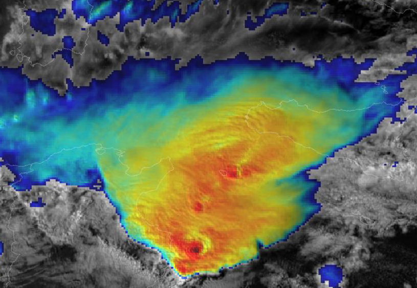
Tomas Pucik gives a presentation on the severe tornado that took place in southern Moravia in June 2021.
Violent (F4 - F5) tornadoes are extremely rare in Europe, which makes it almost impossible for local forecasters or surveyors to build experience with such events. This makes appropriate training for dealing with such events very important. After providing a brief overview of the climatology of tornadoes across Europe, we concentrate on violent tornadoes from three perspectives. The first perspective is typical damage associated with tornadoes of such strength, as documented from a field survey of the Moravian tornado. The second perspective is a contrast of precautions needed to take in such an event compared to the standard set of precautions mentioned in the standard severe wind warnings. The third perspective is an overview of contemporary procedures on forecasting and nowcasting such events compared to the environment and evolution of the 24th June case.
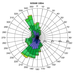
Kathrin Baumann-Stanzer discusses the pros and cons of wind measurements principles and gives a historical overview.
First efforts to observe the wind profile within the lowest kilometres above ground go back to the 1920s. The development of radio transmission led, among other things, to an upswing in the area of radiosondes and captive balloons. The invention of ground-based remote sensing made it possible to monitor continuously the wind profile without costly deployment of personnel. The advantages and disadvantages of measurement principles are discussed based on selected examples from measurement campaigns.
Friedrich Obleitner gives an overview presntation on instruments and techniques used for ground-based wind measurements.
The standard surface wind speed and direction measurements are based on different measurement principles: cup anemometers and vanes, hot wires, pitot tubes and sonic anemometers. Pros and cons of the different measuring methods regarding accuracy and applicability will be discussed as well as some practical aspects concerning setup, maintenance and post-processing. Beyond surface wind measurements, the talk will also touch on ground-based systems to measure vertical wind profiles.
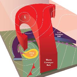
David M. Schultz gives a presentation on the different conceptual models approaches concerning occlusion processes in frontal systems.
This talk presents new conceptual models in cyclone structures and evolutions. How does the large-scale flow in which the cyclone is embedded determine the type of frontal evolution that occurs? How does the air flow through cyclones, and what can this tell us about the possibility for damaging winds at the surface? This talk concludes with general principles for how forecasters can improve their skill through the use of conceptual models in operational forecasting.
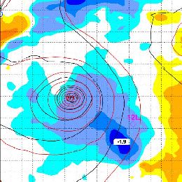
Fernando Prates gives a presentation on forecasting the tracks of tropical cyclones (TC). He gives presents the TC products delivered by ECMWF.
In this module the importance of forecasting tropical cyclones (TC) is briefly discussed. An overview is given of the recent developments in the forecast systems at ECMWF with impact on the forecast of TCs, including the recent change in the model’s resolution and the implementation of the Ensemble Data Assimilation. At the present time, any TC formed in the forecast system can be identified using a tracker developed at ECMWF. How does it work and what kind of products that can be derived from it is discussed. Some examples are also presented to highlight the model's ability to forecast the genesis of TCs. Finally the statistics of the forecast performance for TCs is discussed.
Petra Mikus reports on nowcasting of severe weather using different satellite and NWP based products.
Length: 30 minutes.
Nowcasting of severe convective storms is still one of the most challenging tasks for operational forecasters. Satellite data are very useful in convection nowcasting because they enable a detailed monitoring of the various stages of convection; from the pre-convective environment to specific features on the tops of the mature convective clouds. Also, future MTG system will provide even better tools for convection nowcasting: satellite data with better temporal (every 2.5 min) and spatial resolution.
Various satellite products as well as their advantages and disadvantages for analysis and monitoring of the convective development over the Southern and Central Europe will be shown in the lecture presented by Petra Mikuš Jurković (DHMZ, Croatia). Also, the most interesting convective episodes detected during the 2.5 minute rapid-scan experiments with the MSG satellites will be analysed in detail.
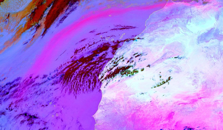
Jochen Kerkmann discusses the characteristics of the Dust RGB and presents the challenges of detecting dust clouds (like low level dust at night over water).
Length: 30 minutes.
Dust and smoke detection with SEVIRI RGB products: the lecture focuses on dust and smoke clouds and their identification in RGB products. The first part looks at the solar channels and the natural colours RGB product; the second part presents the triple window IR channels and the resulting dust RGB product. Some challenges of detecting dust clouds (like low level dust at night over water) will be discussed.

Maria Putsay talks about how to create an RGB image, how to extract, distill, and package the data into products that are easy to interpret and use for forecasters.
Length: 60 minutes.
What is the benefit to work with RGBs not only with single channel images? How to create an RGB image from raw data? How to create a good RGB image? How to enhance features and which features to enhance? Why use standard RGBs? How to extract, distill, and package the data into products that are easy to interpret and use for forecasters?
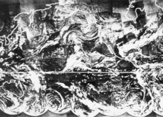
Jochen Kerkmann gives an overview on the historical development of satellites, orbits and instruments.
Length: 30 minutes.
The invention of weather satellites has opened a new area in weather forecasting. Satellite observations enable to continuously monitor the weather regimes on the whole globe. Therefore they provide a powerful tool in weather forecasting. This lecture leads from the invention of weather satellites to the current operational satellites.