
Identify and interpret fields and derived products
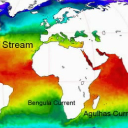
Sea surface temperature (SST), defined as one of the essential climate variables, has a key role in climate research and weather prediction by representing the boundary condition for both the ocean and the atmosphere.
Sea surface temperature (SST), defined as one of the essential climate variables, has a key role in climate research and weather prediction by representing the boundary condition for both the ocean and the atmosphere.
This presentation shows how the SST is retrieved from satellite observations and its main retrieval errors, the instruments and satellites used in its retrieval and the main SST applications. At the end, a brief overview of the future satellite SST-related missions is given.

Scatterometer winds are used by all major NWP centres and by the oceanographic community. At KNMI high resolution ASCAT scatterometer data is assimilated in the NWP High-Resolution Limited Area Model (HiRLAM).
Over the last years the processing of ERS scatterometer winds has been refined. Subsequently, High Resolution Limited Area Model, HIRLAM, and ECMWF model data assimilation experiments have been carried out to assess the impact of one scatterometer, ERS-1 and of two scatterometers, ERS-1 and ERS-2, on the analyses and forecasts. We found that scatterometer winds have a clear and beneficial impact in the data assimilation cycle and on the forecasts. Furthermore, ECMWF has shown that ERS scatterometer data improve the prediction of tropical cyclones in 4Dvar, where unprecedented skillful medium-range forecasts result of potential large social-economic value. Nevertheless, scatterometer winds contain much sub-synoptic scale information where the smallest scales resolved are difficult to assimilate into a Numerical Weather Prediction, NWP, model. This is mainly due to the otherwise general sparsity of the observing system over the ocean. In line with this it is found that scatterometer data coverage is very important for obtaining a large impact. In that respect future scatterometer systems such as SeaWinds on QuikSCAT and ADEOSII, and ASCAT on EPS are promising.
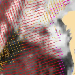
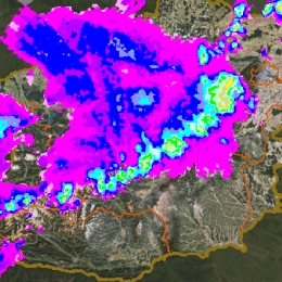
Satellite based scatterometers provide high resolution all-weather wind vector fields over the seas. Wind speed and wind direction are provided at high accuracy under all weather conditions.
Scatterometers uniquely define the mesoscale wind vector field at the sea surface by measuring the radar backscatter signal from wind-generated cm-sized, so-called gravity-capillary sea waves. Because of the wavelength (5 cm), the signal of ASCAT is not affected by rain, and is therefore an "all-weather" system.
The all-weather capability of the ASCAT scatterometer provides unique wind field products of the most intense and often cloud-covered wind phenomena, such as polar front disturbances and tropical cyclones. As such, it has been demonstrated that scatterometer winds are extremely useful in the prediction of extra-tropical and tropical cyclone). Moreover, high-resolution near-surface winds as provided by scatterometers are very relevant because these winds drive the ocean water circulation, which in turn plays a major role in the climate system and in marine life and its exploitation (e.g., fishery).
Presentation divided into three parts; general description of LSA SAF; applications of LSA SAF products ; and the way foward, i.e. perspectives of LSA SAF.
This session is a wrap up of all applications of the LSA SAF products, feedback from users (annual revision by technical and scientific review panels), lessons learned and roadmap for the next phase (2012-2017).
The presentation is divided into three parts; general description of LSA SAF; applications of LSA SAF products ; and the way forward, i.e. perspectives of LSA SAF.
Presentation during the event week on Warning in October 2010.
Presentation by Tanja Renko (DHMZ) who describes the warning system that was active in Croatia before joining the Meteoalarm. Then the decision process in giving a warning for Meteoalarm and the local authorities will be described using an example of a real warning case.
Presentation during the event week on Warning in October 2010.
Presentation by Michael Staudinger talks about the EMMA project and the meteoalarm website that integrates all important severe weather information originating from the official National Public Weather Services across a large number of European countries. The warning information is presented consistently to ensure coherent interpretation as widely as possible throughout Europe.
Presentation during the event week on Warning in October 2010.
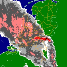
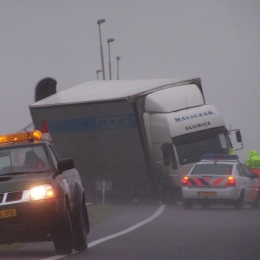
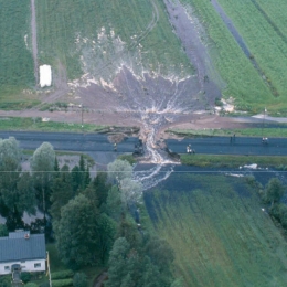
Rob Groenland will look into more detail in the July 14th case of 2010. He will describe the meteorological part on the synoptic- and mesoscale. Furthermore he pays attention to the decision making process that finally lead to the issuing of a regional weather alarm for parts of the Netherlands that evening. Not only beforehand it is important the follow the procedures carefully but also in the aftermath it is essential to collect all the feedback and communication that took place between the expert- and weatheralarmteam but also from customers, end users and general public. Finally he shows you the results of an extensive KNMI damage survey that took place in the area of the most severe damage.
Presentation during the event week on Warning in October 2010.
KNMI takes great interest in collaborative decision making within the process towards issuing severe weather warnings. Collaborative decision making will equalize individual peak reactions by forecasters, it will also decrease the stress often felt by shift meteorologists in the onset phase towards a severe weather event. For this reason KNMI has implemented several consulting procedures within its new warning system.
During the first part of this presentation Frank Kroonenberg will tell you about setting objective warning threshold, the warning colour assignment system and will give more details on the decision making process that leads to a warning for extreme weather or even a weather alarm the highest state of warnings in the Netherlands.

Presentation during the event week on Warning in October 2010.
Finnish warnings are issued on 24/7 routines via radio, television and www. Warnings are provided for general public, authorities and commercial clients. Warnings are issued for the next 24 hours in advance, but in future outlooks for some days in advance will be issued in near future. In weather situations where it is estimated that weather will be hazardous an extra forecaster monitors the situation and makes situation awareness reports for authorities. Also authority bulletins for general public are possible in severe weather situations.
Presentation during the event week on Warning in October 2010.
Rainfall warnings have not been issued in Finland until 2009. In the earlier years heavy rain forecasting was considered to be a too challenging task. However, growing demand for warnings together with some advancements in forecasts have changed this. Nowadays FMI provides warnings for the general public, authorities and commercial clients. In this presentation FMI's heavy rain warnings are presented and discussed.
Presentation during the event week on Warning in October 2010.
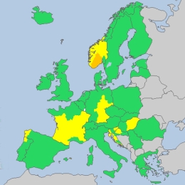
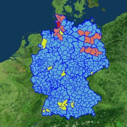
Instead of fixed warning thresholds, ZAMG has introduced the principle of annualities for their warning parameters. This decision was also chosen because most European NMSs also do it like this way. A yellow warning means that a situation exists only 17 times per year, which is an event which should be cautiously observed, but for which experience exists; an orange warning describes a situation which is only 3 times per year observed, therefore increased alert is necessary; a red warnng is an event which appears only 1 to 3 times per years and is therefore an extreme event.
Presentation during the event week on Warning in October 2010.
Presentation developed by Guido Wolz, Rolf Ullrich, Bernhard Reichert and Wilfried Jacobs on the warning system at Deutscher Wetterdienst (DWD). The issue of weather warnings by DWD is a task according to law. Especially if weather situations can cause danger for persons and material.
The warning management is split in 3 parts: Early warning in which information as possibility (very likely, likely possible) of significant weather situations on a national scale (250-700 km) from 2 day to one week. Pre-warnings in which severe weather situations on a regional scale (50-250 km) from 1 to 2 days is expected. Finally, rural district warnings where concrete warnings are issued for one or more rural district with a preliminary lead time; if necessary with differentiation of height levels.