
Land
David Fairbairn presents examples of downloading, converting the format to regular netCDF files and visualizing the data in Python.
Length: 19 minutes.
H-SAF root-zone soil moisture products are freely available online. They are currently stored in daily files on a reduced Gaussian grid in GRIB binary format, which increases storage efficiency. Examples of downloading, converting the format to regular netCDF files and visualizing the data in Python are presented. The new metview-python package is also introduced, allowing direct applications in GRIB format.

Apostolos Giannakos introduces the Python library that can be used for reading, comparison and validation of soil moisture datasets.
Length: 27 minutes.
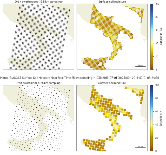
H-SAF Surface Soil Moisture (SSM) products that are comprised of Near Real-Time (NRT) SSM products and Climate Data Record (CDR) products are freely available at the H SAF data portal. Examples of downloading, reading and displaying SSM data in Python are presented. Ascat python software package that reads and converts data derived from the Advanced Scatterometer (ASCAT) on-board the series of Metop satellites and pytesmo python library that can be used for reading, comparison and validation of geospatial time series soil moisture datasets are introduced.
Sebastian Hahn discusses the algorithmic background of the ASCAT SSM retrieval and describes the properties and characteristics of currently available ASCAT SSM products.
Length: 32 minutes.
H-SAF Surface Soil Moisture (SSM) products are derived from the Advanced Scatterometer (ASCAT) on-board the series of Metop satellites operating in space since more than 14 years. The SSM retrieval is based on a semi-empirical change detection method developed by TU Wien, which exploits the multi-incidence angle measurement capability of the fan-beam scatterometer ASCAT. While ASCAT Near Real-Time SSM products are most current and well suited for Near Weather Prediction (NWP), ASCAT Climate Data Record (CDR) products ensure long-term consistency and stability. This presentation will discuss the algorithmic background of the ASCAT SSM retrieval and describe the properties and characteristics of currently available ASCAT SSM products.
The presenters show examples for the use of SM data in identifying drought conditions in some regions worldwide.
Length: 25+14 minutes.
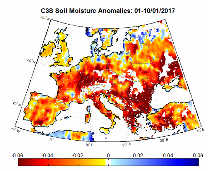
Satellite soil moisture (SM) products are highly suitable for monitoring agricultural drought. As satellite SM products cover long time periods and are available for large regions, the spatial and temporal analysis of drought conditions can be performed. The presentation will describe the theoretical background for performing drought analysis with satellite SM data, and will show some examples for the actual use of the data in identifying drought conditions in some regions worldwide.
Simone Gabellani and Fabio Delogu describe how soil moisture estimated trough satellite can be compared and validated with other sources of information.
Length: 38+39 minutes.
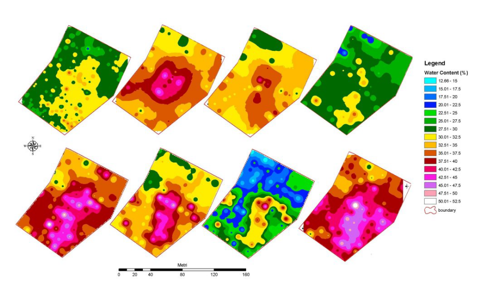
Soil Moisture is a crucial variable in hydrological applications. It can be measured and estimates in different way and along different spatial and temporal scale. The presentation describes how soil moisture estimated trough satellite can be compared and validated with other sources of information; theoretical basis and practical example will be showed.
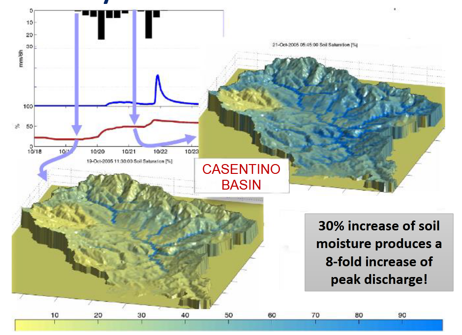
Stefania Camica and Lucca Brocca describe the theoretical background for using satellite SM products in flood prediction.
Length: 19+24 minutes.
Satellite soil moisture (SM) products have been largely used for flood prediction. The knowledge of initial soil moisture conditions before a rainfall event is critical to determine the magnitude of a flood event. The presentation will describe the theoretical background for using satellite SM products in flood prediction, and will show examples for understanding the critical role of initial soil moisture for predicting floods.

Nicola Berni presents the impact of soil moisture products for flood and land slide warning.
Length: 17 minutes.
Umbria Region Civil Protection Early Warning center (Central Italy) is in charge of alerting and monitoring critical events for Civil Protection purposes (mainly landslides and floods). In last ten years the office has used, in cooperation with national research institutes, satellite data to improve modeling/forecasting tools performances, monitoring activities about possible impacts of severe rainfall events able to trigger floods and landslides at regional scale. In fact, the estimation of the soil water content has proved to be a key parameter for better forecast models implementation both for landslide than for flood risk issues.
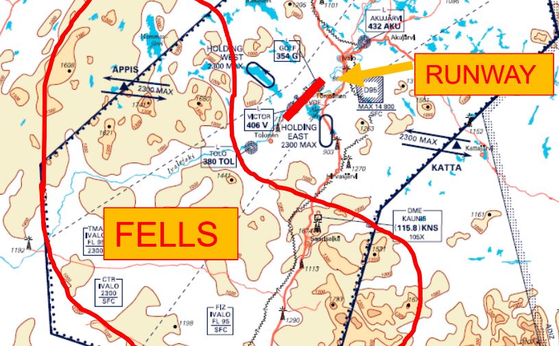
Elina Tuhkalainen treats the formation and dissipation of fog at airports in Finland.
Length: 35 min
Author: Elina Tuhkalainen (FMI)
In this presentation formation and dissipation of fog and stratus will be treated. The presenters will also address how these phenomena occur around the year and how they affect the services at the airports in Finland.
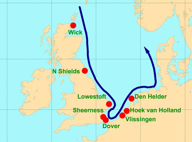
Hans De Vries focusses in his presentation on the situation in The Netherlands, where storm surge forecasts are generated by WMCN and KNMI.
Length: 45 min
Author: Hans de Vries (KNMI)
Several countries along the North Sea have densely populated areas and major political and economic activities close to the coast - places that are vulnerable to storm surges. To protect these areas coastal defence requires continuous attention. Several storm surge barriers have been constructed over the last decades that can be closed if the water level rises too high. Examples are the Thames Barrier in London and the Maeslantkering near Rotterdam. To alert local authorities and to operate the movable barriers efficiently, good and timely storm surge forecasts are essential. These forecasts make use of state-of-the-art meteorological forecasts and techniques like ensemble forecasting. This presentation will focus on the situation in The Netherlands, where storm surge forecasts are generated in close cooperation between the Water Management Centre Netherlands (WMCN) of Rijkswaterstaat and the Royal Netherlands Meteorological Institute (KNMI).
Presentation 1 of the Environment Event Week 2016
Length: 30 min
Author: Oleg Dubovik (University of Lille)
The GRASP (Generalized Retrieval of Aerosol and Surface Properties) algorithm has been developed for enhanced characterization of the properties of both aerosol and land surface from diverse remote sensing observations. The overall concept of the algorithm is described by Dubovik et al. (2014), while the detailed are given in the paper is by Dubovik et al. (2011). The algorithm is based on highly advanced statistically optimized fitting implemented as Multi-Term Least Square minimization (Dubovik, 2004) and deduces nearly 50 unknowns for each observed site. The algorithm derives a set of aerosol parameters similar to that derived by AERONET including detailed particle size distribution, the spectral dependence on the complex index of refraction and the fraction of non-spherical particles. The algorithm uses detailed aerosol and surface models and fully accounts for all multiple interactions of scattered solar light with aerosol, gases and the underlying surface. All calculations are done on-line without using traditional look-up tables. In addition, the algorithm can use the new multi-pixel concept - a simultaneous fitting of a large group of pixels with additional constraints limiting the time variability of surface properties and spatial variability of aerosol properties. This principle provides a possibility to improve retrieval for multiple observations even if the observations are not exactly co-incident or co-located. Significant efforts have been spent for optimization and speedup of the GRASP computer routine and retrievals from satellite observations. For example, the routine has been adapted for running at GPGPUs accelerators. GRASP inherits many aspects used in AERONET retrieval. At first GRASP has been developed for POLDER/PARASOL multi-viewing imager and later adapted to a number of other satellite sensors such as METEOSAT/MERIS at polar-orbiting platform and COCI/GOMS geostationary observations. It can be equally applied to ground-based AERONET and lidar observations. The results of numerical tests and results of applications to real data will be presented.

Presentation 4 the Environment Event Week 2016
Length: 30 min
Author: Stefan Schneider (ZAMG)
Droughts are one of the most severe natural hazards with regard to affected people, spatio-temporal extension and economic losses. At the same time, population growth is expected to put global agricultural production under increasing pressure. Thus, drought monitoring and forecasting systems would be essential for large parts of the globe, and satellites are a valuable data source to establish such monitoring systems.
The presentation will give examples on the relevant parameters measured by satellites, whereas the focus will be on soil moisture. Furthermore, the combination of satellite measurements and model forecasts will be described to point out the state-of-the-art possibilities in forecasting drought events. Examples from an existing system will be presented for the region of Eastern Africa.
Presentation 7 in the Environment Event Week 2016
Length: 50 min
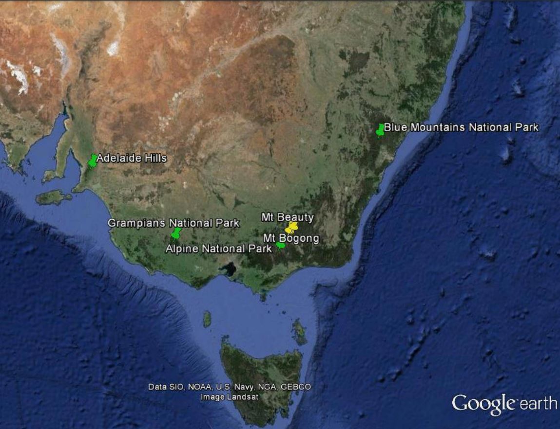
Author: Mike Willmott (BOM)
Apart from the central desert areas, the Australian landscape, from the tropics of Far North Queensland to the southern tip of Tasmania has climatic conditions and vegetation which are conducive to wildfires throughout the year. The most volatile of these areas being the south eastern parts of Australia which includes the states of South Australia, Victoria, New South Wales and Tasmania. Australia has large tracts of wilderness which can only be monitored by aircraft and satellite and as such, remote sensing for bushfires within the landscape is virtually mandatory throughout the dry season in the tropics and the summer periods for the southern states. This talk looks at some of the ways that Satellite Remote Sensing has assisted emergency managers for preparedness, response and recovery, the three most important factors for any emergency operation.