
Hydrology & water management
Listed here are other resources related to Hydrology & water management tag:
Note: click on an image to open the Resource

Apostolos Giannakos introduces the Python library that can be used for reading, comparison and validation of soil moisture datasets.
Length: 27 minutes.
H-SAF Surface Soil Moisture (SSM) products that are comprised of Near Real-Time (NRT) SSM products and Climate Data Record (CDR) products are freely available at the H SAF data portal. Examples of downloading, reading and displaying SSM data in Python are presented. Ascat python software package that reads and converts data derived from the Advanced Scatterometer (ASCAT) on-board the series of Metop satellites and pytesmo python library that can be used for reading, comparison and validation of geospatial time series soil moisture datasets are introduced.
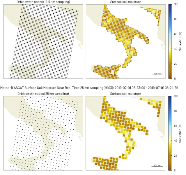
Sebastian Hahn discusses the algorithmic background of the ASCAT SSM retrieval and describes the properties and characteristics of currently available ASCAT SSM products.
Length: 32 minutes.
H-SAF Surface Soil Moisture (SSM) products are derived from the Advanced Scatterometer (ASCAT) on-board the series of Metop satellites operating in space since more than 14 years. The SSM retrieval is based on a semi-empirical change detection method developed by TU Wien, which exploits the multi-incidence angle measurement capability of the fan-beam scatterometer ASCAT. While ASCAT Near Real-Time SSM products are most current and well suited for Near Weather Prediction (NWP), ASCAT Climate Data Record (CDR) products ensure long-term consistency and stability. This presentation will discuss the algorithmic background of the ASCAT SSM retrieval and describe the properties and characteristics of currently available ASCAT SSM products.
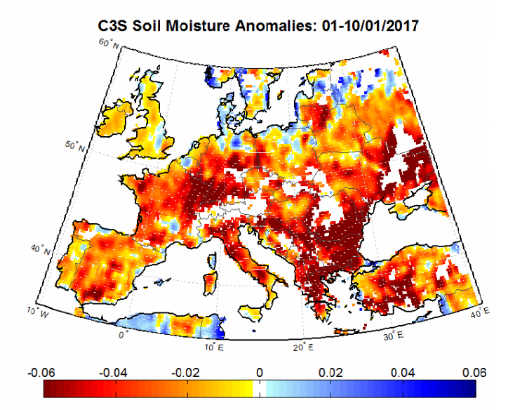
The presenters show examples for the use of SM data in identifying drought conditions in some regions worldwide.
Length: 25+14 minutes.
Satellite soil moisture (SM) products are highly suitable for monitoring agricultural drought. As satellite SM products cover long time periods and are available for large regions, the spatial and temporal analysis of drought conditions can be performed. The presentation will describe the theoretical background for performing drought analysis with satellite SM data, and will show some examples for the actual use of the data in identifying drought conditions in some regions worldwide.
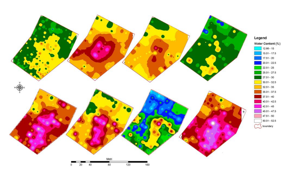
Simone Gabellani and Fabio Delogu describe how soil moisture estimated trough satellite can be compared and validated with other sources of information.
Length: 38+39 minutes.
Soil Moisture is a crucial variable in hydrological applications. It can be measured and estimates in different way and along different spatial and temporal scale. The presentation describes how soil moisture estimated trough satellite can be compared and validated with other sources of information; theoretical basis and practical example will be showed.
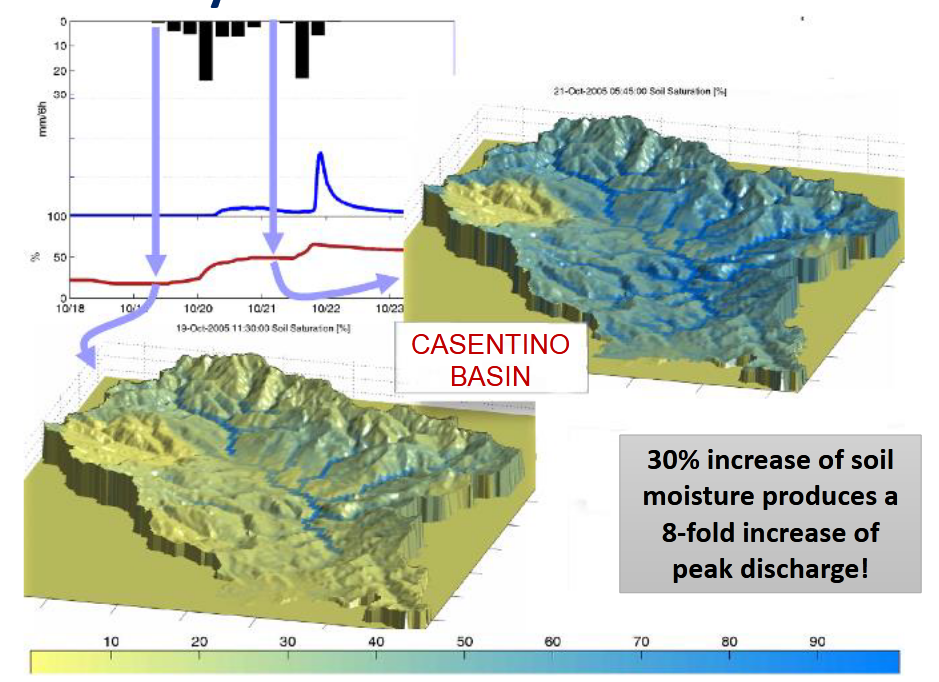
Stefania Camica and Lucca Brocca describe the theoretical background for using satellite SM products in flood prediction.
Length: 19+24 minutes.
Satellite soil moisture (SM) products have been largely used for flood prediction. The knowledge of initial soil moisture conditions before a rainfall event is critical to determine the magnitude of a flood event. The presentation will describe the theoretical background for using satellite SM products in flood prediction, and will show examples for understanding the critical role of initial soil moisture for predicting floods.
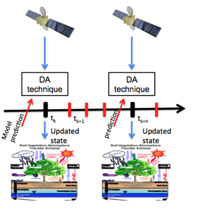
Simone Gabellani and Fabio Delogu describe how satellite soil moisture can be used in hydrological modelling trough data assimilation.
Length: 37+27 minutes.
The reliable estimation of hydrological variables in space and time is of fundamental importance in hydrology to improve the flood predictions and hydrological cycle description. Nowadays remotely sensed data can offer a chance to improve hydrological models especially in environments with scarce ground-based data. The presentation describes how satellite soil moisture can be used in hydrological modelling trough data assimilation.

Nicola Berni presents the impact of soil moisture products for flood and land slide warning.
Length: 17 minutes.
Umbria Region Civil Protection Early Warning center (Central Italy) is in charge of alerting and monitoring critical events for Civil Protection purposes (mainly landslides and floods). In last ten years the office has used, in cooperation with national research institutes, satellite data to improve modeling/forecasting tools performances, monitoring activities about possible impacts of severe rainfall events able to trigger floods and landslides at regional scale. In fact, the estimation of the soil water content has proved to be a key parameter for better forecast models implementation both for landslide than for flood risk issues.
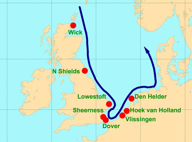
Hans De Vries focusses in his presentation on the situation in The Netherlands, where storm surge forecasts are generated by WMCN and KNMI.
Length: 45 min
Author: Hans de Vries (KNMI)
Several countries along the North Sea have densely populated areas and major political and economic activities close to the coast - places that are vulnerable to storm surges. To protect these areas coastal defence requires continuous attention. Several storm surge barriers have been constructed over the last decades that can be closed if the water level rises too high. Examples are the Thames Barrier in London and the Maeslantkering near Rotterdam. To alert local authorities and to operate the movable barriers efficiently, good and timely storm surge forecasts are essential. These forecasts make use of state-of-the-art meteorological forecasts and techniques like ensemble forecasting. This presentation will focus on the situation in The Netherlands, where storm surge forecasts are generated in close cooperation between the Water Management Centre Netherlands (WMCN) of Rijkswaterstaat and the Royal Netherlands Meteorological Institute (KNMI).
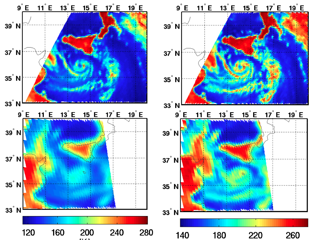
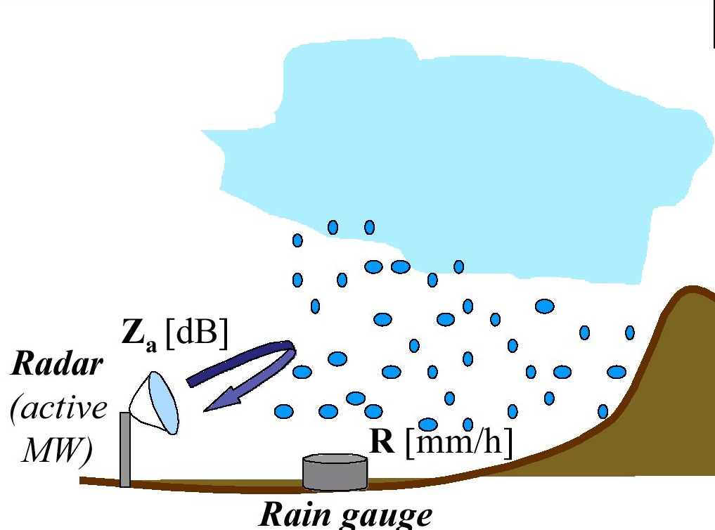
Giulia Panegrossi provides an overview on the state-of-the-art of remote sensing techniques for precipitation retrieval.
Length: 34 minutes
The goal of this seminar is to provide an overview of the state-of-the-art of remote sensing techniques for precipitation retrieval exploiting Low Earth Orbit (LEO) microwave (MW) and/or geostationary (GEO) visible/infrared (VIS/IR) observations, analyzing their potentials and limitations, and perspectives in view of future satellite missions. The first part will focus on the description of the main space borne observing systems with focus on passive MW sensors on board LEO satellites, and on the basic principles of precipitation retrieval from space. Particular emphasis has been given to the NASA/JAXA Global Precipitation Measurement (GPM) mission, and to its Core Observatory launched on February 27, 2014, equipped with the most advanced space borne microwave imager (the GMI) and the first space borne dual-frequency (Ku and Ka-band) precipitation radar, providing semi-global (between 65°S and 65°N) 3-D view and retrieval of the precipitation (solid and liquid). The second part will focus on the main precipitation retrieval techniques and in particular on those used in the EUMETSAT Hydrology Satellite Application Facility (H SAF) precipitation products. Finally, in the third part a few applications of satellite precipitation products will be shown to highlight scientific challenges and future perspectives to improve precipitation quantitative estimation from space.
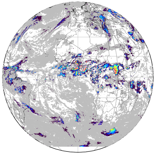
Silvia Puca gives an overview on H-SAF activities and products.
Length: 28 minutes
H SAF products and applications fit with the objectives of services, agencies, authorities and other initiatives which need information on water at the ground in order to monitor hazards and natural disasters such as flash floods, landslides and drought conditions, as well as to improve water management. From 2005 H SAF started to provide remote sensing estimates of relevant hydrological parameters: instantaneous rain rate and cumulated rainfall, soil moisture at surface and in the root zone, snow cover and water equivalent. All products are available via EUMETSAT data delivery service (EUMETCast), or via ftp download; they are also published in H SAF website h-saf.eumetsat.int. The project involves experts from 12 national meteorological and hydrological European Institutes of Austria, Belgium, Bulgaria, Finland, France, Germany, Hungary, Italy, Poland, Romania, Slovakia and Turkey, and from ECMWF.
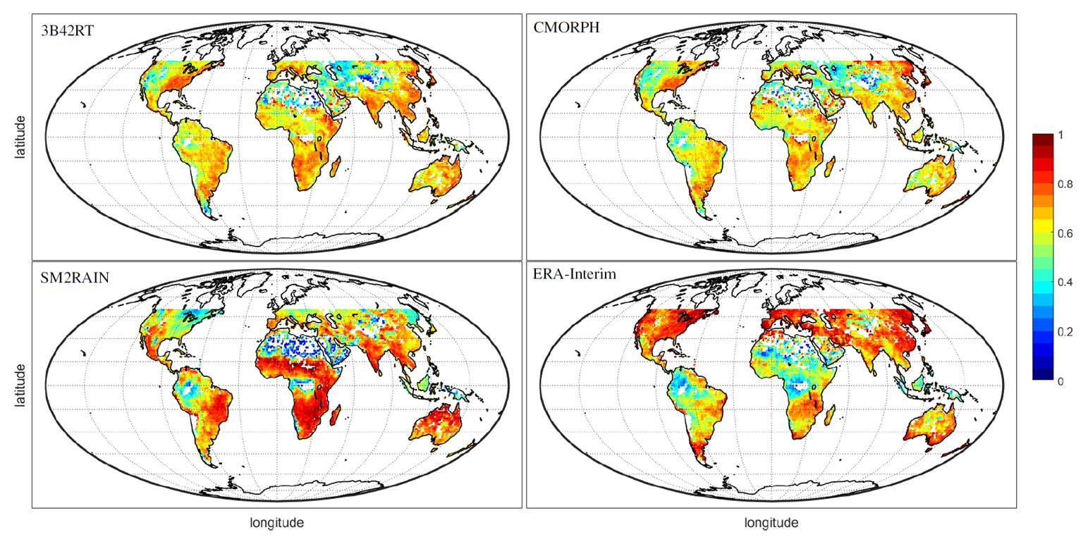
Luca Ciabatta presents an algorithm that retrieves precipitation amounts from soil moisture measurements.
Length: 19 minutes
SM2RAIN is a novel algorithm that allows to estimate rainfall from a different perspective, using the soil as a natural rain gauge. The algorithm has already been applied to several satellite soil moisture products both on a regional and global scale, providing high-quality rainfall data. Moreover, soil moisture-derived rainfall estimates have been found to be complementary to state-of-the-art top-down precipitation products. In this way, the integration of the two different approaches provides a more reliable rainfall product. Within H SAF, the SM2RAIN algorithm has been applied to Surface Soil Moisture (SSM) data obtained through Metop platforms. The SSM-derived rainfall data are then integrated with the Level 3 PMW H67 product. In this way, the integrated product P-AC-SM2RAIN (labeled as H64) can provide daily rainfall estimates with a spatial resolution of 0.25°, over the extended H SAF area (LAT 60°S – 75°N, LON 60°W – 60°E).
Simone Gabellani presents a merging approach of rain gauge data with remote precipitation retrieval to improve flood modelling.
Length: 68 minutes
Multi-sensor data fusion prove that combining data from rain gauges and remote retrievals represents the best way to obtain an enhanced and more reliable evaluation of Quantitative Precipitation Estimation (QPE) that improve hydrological modelling for river discharge estimation. Although remote sensors produce an observation of precipitation subject to several sources of uncertainty, they capture the general covariance structure of the precipitation field. Thus, the information provided by remote sensors may be used to condition the information from rain gauges, which is limited in terms of spatial representativeness. In this way, an estimate of the rainfall field containing a more realistic spatial structure constrained to the rain gauges data can be produced. The presentation will describe the theoretical background and examples for merging satellite and gauge rainfall data for improving discharge modelling. A Modified Conditional Merging (MCM) approach, developed from the original Conditional Merging proposed by Sinclair and Pegram (2005), will be illustrated.