
Marine forecasting
Listed here are other resources related to Marine forecasting tag:
Note: click on an image to open the Resource
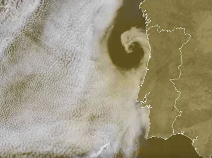
Hans Peter Roesli discusses various satellite pattern observed over the seas.
Length: 40 min
Author: Hans Peter Roesli, Switzerland
Sea and coastal areas have radiative characteristics that enhance the identification of non-meteorological features like smoke, ash or dust. Maritime inversions and atmospheric interchanges along coastal areas engender particular cloud patterns like Bénard cells, Kármán vortex streets, undular bores, ship trails, (extra) tropical cyclones or sea breeze fronts. Examples of such features will be shown and discussed, using imagery from geostationary and polar weather satellites.
Presentation 3 in the Marine Forecasting Course 2017
Length: 112 min
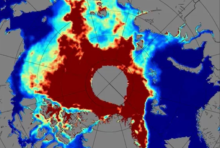
Author: Rasmus Tonboe (DMI)
Sea ice has always posed a threat to ships sailing through the northern Atlantic and also the ice was a clear indication of climate changes since the start of satellite observations in the 1970s. Satellites from their beginning have helped very much in tracking the condition and movements of ice sheets over North Pole and Antarctica. Sea ice condition, its melting and freezing over again in winter are important to track to see how they are affecting the weather and climate in these parts. Many satellite products and models were developed to distinguish thin one year ice from the thicker multiyear ice and to determine the actual thickness of these sheets. Further questions like how does ice affect radiation, how does snow affect the ice and what is the quality of the models that are used, will be answered during this lecture.
Presentation 2 in the Marine Forecasting Course 2017
Length: 117 min
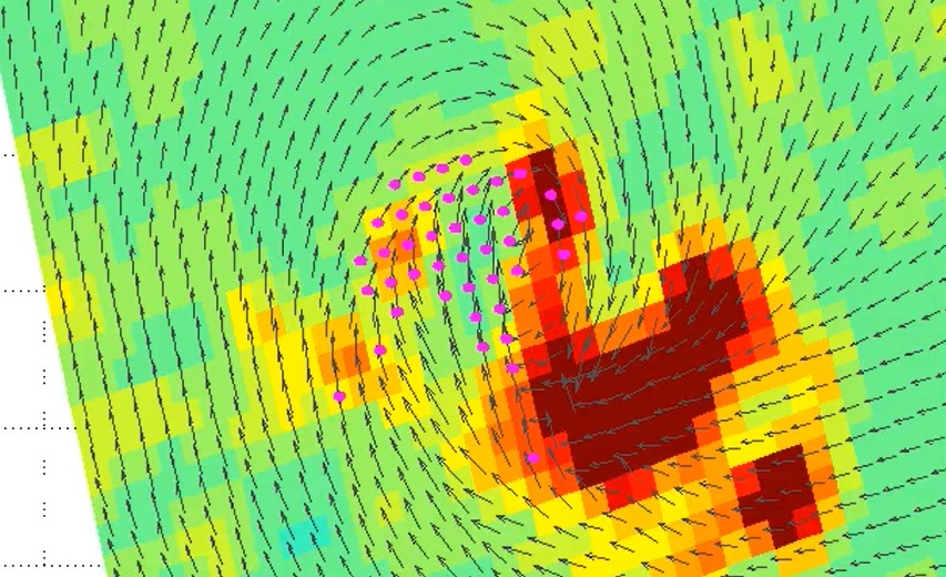
Author: Ad Stoffelen
The lecture deals with modelled winds and winds derived from instruments onboard satellites like Metop-A and Metop-B in low orbits around the Earth (polar orbits). Today's models are evolving at a rate that is faster than the increase of density of observations and that presents a problem for forecasts. Here stands the question 'Will meteorology continue to develop and improve?'. The lack of observed data is thus filled with the data from satellites, although this data also has its own constraints due to the way it is derived. In the lecture the characteristics of the satellites carrying instruments for measuring winds and waves will be explained and the logic behind the calculations of winds using satellites will be discussed.
Scatterometer data are used for many different purposes in marine meteorology, e.g. warnings, enhancement of situational awareness for winds, monitoring of storm evolution, low pressure systems, etc., therefore marine forecasters using the products about wind and waves from satellites will be instructed how to use them and when to combine the data with model outputs.
Presentation 1 in the Marine Forecasting Course 2017
Length: 59 min
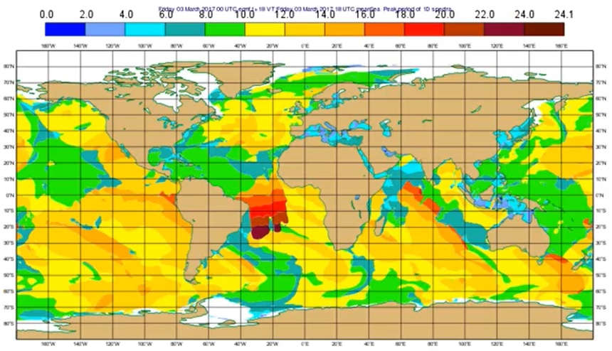
Author: Jean Bidlot (ECMWF)
Starting from the basics, this lecture introduces the students to wave model products (e.g. wave height and mean propagation direction), wave spectrum analysis, long swell forecasts, extreme forecast index etc. Since these outputs (alongside data from the buoys) are the basic material marine forecasters have for forecasting and nowcasting waves in seas and especially in oceans, explaining the positive and negative sides of model outputs is very important for understanding and thus correctly using the products marine forecasters use.
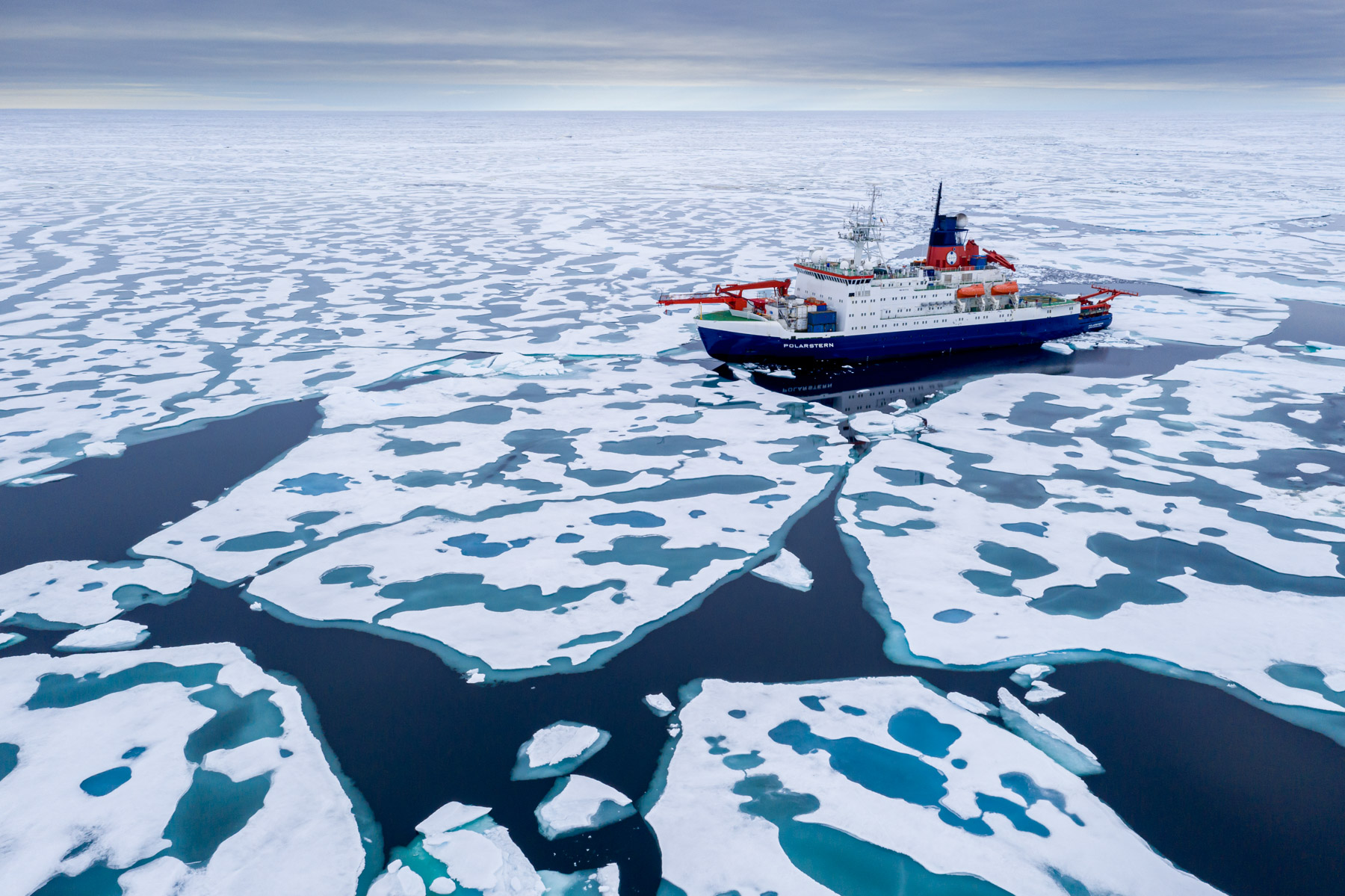
Oliver Sievers and Jens Kieser report from the MOSAiC expedition of the German vessel Polarstern in the Arctic Sea.
Meteorologists and weather technicans from the German Meteorological Service (DWD) attended the entire MOSAiC expedition, the largest-scale Central Arctic research expedition of all time. They were responsible for permanent weather observations and daily meteorological forecasts for scientists, ship master and officers, as well as helicopter pilots. Our presentation will report about personal experiences of a meteorologist on board of the research icebreaker POLARSTERN, with the focus on the daily work of the forecaster and the importance of using satellite images in Polar Regions.
Steinar Eastwood presents the OSI-SAF products and shows climatological applications of the data.
The sea ice products from the EUMETSAT Ocean and Sea Ice Satellite Application Facility are widely used. In this presentation the sea ice products will be presented and examples of use in operational numerical weather and ocean modelling will be given.