
Land
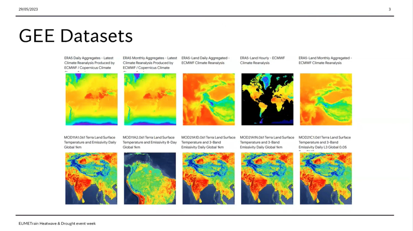
Sofia Ermida showcases the use of Google Earth Engine in Heatwaves and Drought monitoring
The Google Earth Engine (GEE) is a powerful tool for researchers providing easy access to a large array of environmental datasets, particularly from remote sensing, and the computational resources to analyzed them. Here we present an overview of the capabilities and datasets of the GEE useful for the study of heatwaves and droughts and provide some examples of applications.
Learn to distinguish between dust and smoke.
This module teaches you how to use satellite data to observe and analyze atmospheric phenomena. It will show you which products can be used to identify dust storms, smoke, fires, precipitation, etc.
To access the resource click here.
Note: all resources are provided as an external link which redirects you to https://eumetcal.eu where you will need to create a user account in order to gain access to the course

Identify and locate fires and smoke.
This module teaches you how to use satellite data to observe and analyze atmospheric phenomena. It will show you which products can be used to identify dust storms, smoke, fires, precipitation, etc.
To access the resource click here.
Note: all resources are provided as an external link which redirects you to https://eumetcal.eu where you will need to create a user account in order to gain access to the course
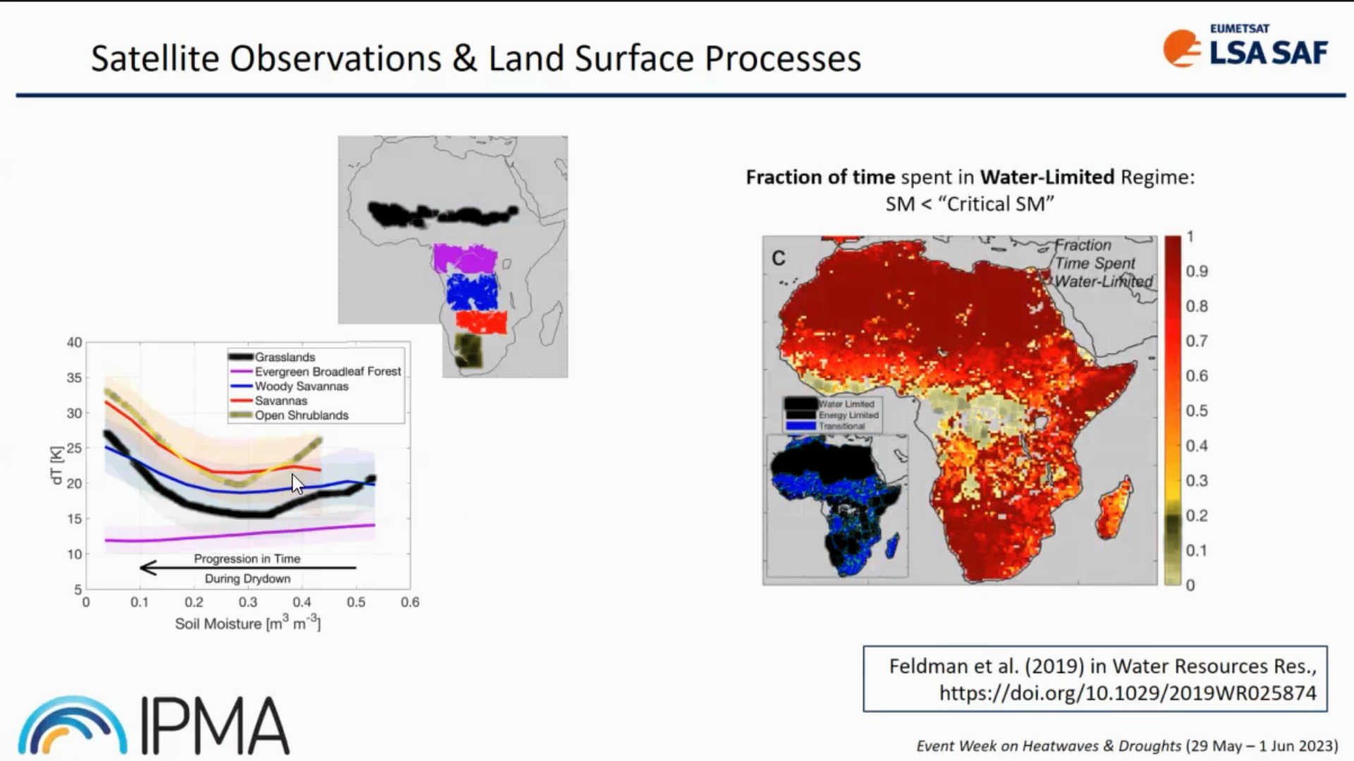
Isabel Trigo provides insight into LSA SAF datasets and its usage.
Heat and water stress leave clear signatures on land surface variables that can be monitored from space. The LSA SAF has been providing satellite datasets and products that allow the characterization of the surface energy budget and the monitoring of vegetation growth and stress. We will show that the combination of information on the surface temperature diurnal cycle and on vegetation state provides a different perspective on the spatial extent and time evolution of droughts and heatwaves, and reveals underlying soil vegetation-atmosphere feedbacks.
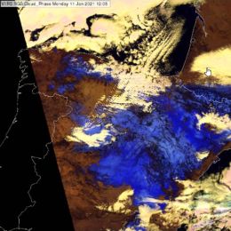
This case study treats snow detection with the Cloud Phase RGB.
During 07-10 January 2021, a winter storm produced a significant 30-50 cm snow depth over large parts of Spain. We studied this snow cover over the following ten days in VIIRS Cloud Phase RGB images. The Cloud Phase RGB is a composite image, which will also be available with data from the future Meteosat Third Generation (MTG) imager.
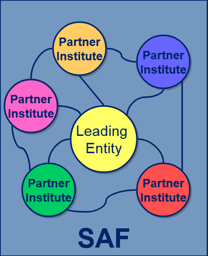
Lothar Schueller gives an overview on the SAF structure and the generated products.
Length: 30 minutes.
SAFs are dedicated centres of excellence for processing satellite data, achieved by utilising specialist expertise from the Member States. SAFs generate and disseminate operational EUMETSAT products and services and are an integral part of the distributed EUMETSAT Application Ground Segment.
Each SAF is led by the National Meteorological Service (NMS) of a EUMETSAT Member State, in association with a consortium of EUMETSAT Member States and Cooperating States, government bodies and research institutes. The lead NMS is responsible for the management of each complete SAF project. The research, data and services provided by the SAFs complement the standard meteorological products delivered by EUMETSAT’s central facilities in Darmstadt, Germany.

Maria Putsay talks about how to create an RGB image, how to extract, distill, and package the data into products that are easy to interpret and use for forecasters.
Length: 60 minutes.
What is the benefit to work with RGBs not only with single channel images? How to create an RGB image from raw data? How to create a good RGB image? How to enhance features and which features to enhance? Why use standard RGBs? How to extract, distill, and package the data into products that are easy to interpret and use for forecasters?
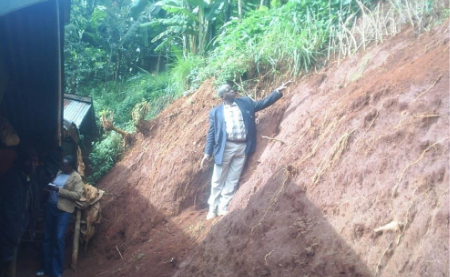
Humberto Barbosa talks on the use of satellite precipitation products for mapping land slides in Brazil.
Length: 50 minutes.
Research during the past decade has documented the importance of satellite precipitation products to the overall workings of the tropical landslide susceptibility. Several types of satellite precipitation products are used for landslide assessment but the area they see, and the frequency of observations, varies. Two complementary types are particularly relevant to landslide management. Polar-orbiting satellites fly in a relatively low orbit (often at around 1000km above the ground), providing relatively high spatial resolution. But they only collect data over the same point once every few days. Geostationary satellites are positioned at a much higher altitude (about 36,000km). They orbit the Earth at the same speed as the Earth rotates on its axis, in effect remaining stationary above the ground and viewing the whole earth disk below. Their spatial data is much coarser, but is collected at the same point every 15 minutes. Moreover, rainfall-triggered landslides tend to be local-scale features, but ground conditions are also very important. When they destroy people's lives and livelihoods, they become natural disasters. Thus, Understanding the nature of spatial and temporal variability of rainfall events in developing countries is important to improve the landslide-prediction science. This seminar will present an overview of recent landslide examples in Brazil and applications of satellite precipitation products. A key satellite input dataset for the integrated applications is the EUMETSAT’s Satellite Application Facility on Support to Operational Hydrology and Water Management.
Peter Salamon provides an overview on EFAS (European Flood Awareness System).
Length: 40 minutes.
The disastrous floods in Elbe and Danube rivers in 2002 confronted the European Commission with non-coherent flood warning information from different sources and of variable quality, complicating planning and organization of aid. In response to this event, the European Commission initiated the development of a European Flood Awareness System (EFAS) to increase the preparedness for floods in Europe.
The aim of EFAS is to gain time for preparedness measures before major flood events strike particularly for trans-national river basins both in the Member States as well as on European level. This is achieved by providing complementary, added value information to the National hydrological services and by keeping the European Response and Coordination Centre informed about ongoing floods and about the possibility of upcoming floods across Europe. Since 2012 EFAS is running fully operational as part of the COPERNICUS Emergency Management Services.
This presentation will provide an overview of the following basic principles employed in EFAS: (1) the use of ensemble predictions in flood forecasting, (2) employing model climatology to derive return period statistics and (3) communication and visualization of uncertain results for decision making. Furthermore, the flash flood predictions as computed in EFAS will be presented.
Further information on EFAS can be found on www.efas.eu.
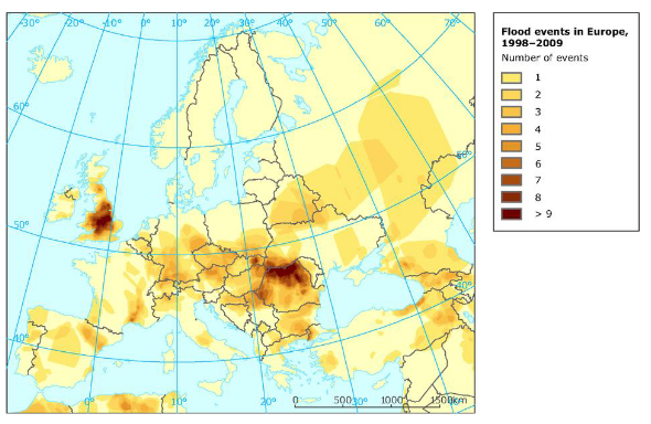
Natasa Strelec Mahovic investigates 5 years of flood events in Europe.
Length: 37 minutes.
In the last decade devastating floods occurred in Europe every year taking lives and causing great damages. In this presentation synoptic situations leading to the largest floods affecting Europe in the last 5 years will be analized. The main idea is to pinpoint the similarities and differences in synoptic patterns in order to improve the forecast of such events.
Joseph Kagenyi talks about forecasting land slides in Africa.
Length: 46 minutes.
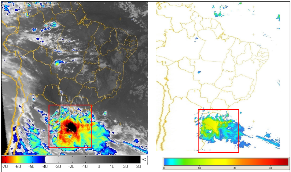
The monitoring of weather characteristics over the equatorial and tropical regions is well covered with both polar and geostationary satellites hence the satellite becomes a very important instrument on severe weather monitoring and forecasting. The application of multispectral data of MSG in the monitoring the microphysics of clouds such as deep convective clouds with RGB composites provides in-depth understanding in the identification of regions where extremely active storms are located. The use of Multi sensor Precipitation estimate (MPE) also helps in the estimation total of accumulated rainfall on each region during the storm period. Such areas can easily be monitored and the possibility of excess rainfall within a day can be evaluated and such information is used to issue a warning for evacuation, or for support to the potential victims on these areas.
In short RGB composites, MPE Estimates, and the accumulated rainfall on daily basis becomes effective tools of landslide forecasting. We also add the NWP products particularly the High resolution (7 km) COSMOS data and NCEP CPC data as it gives a forecast with indications of possibly of heavy storms. However with satellite data you are able to ascertain which areas would the forecast show excess impact on the ground. The NWP products are used to help in creating accumulated rainfall values (estimates) necessary in establishing the threshold values for remote areas where station gauge data is not available.
Bob Adler talks on TRMM/GPM rainfall for landslide prediction.
Length: 35 minutes.
A Global Flood Monitoring System (GFMS) has been developed and tested to provide real-time flood detection and streamflow estimates using NASA multi-satellite precipitation data calibrated by TRMM and, in the near future, by the GPM core satellite. Images and output data are available for use by the disaster relief and science communities with updates available every three hours (http://flood.umd.edu). The system currently uses the TRMM Multi-satellite Precipitation Analysis [TMPA]) and a hydrological and routing combination model, the Dominant river Routing Integrated with VIC Environment (DRIVE) system. The land surface and runoff calculations are carried out at 0.125 latitude-longitude resolution with routing and streamflow calculations done at that resolution and also at 1km resolution. Examples of results for recent flood events will be presented, including calculated inundation maps compared to those estimated from MODIS data. Results from a system to estimate landslide potential are also available at (http://trmm.gsfc.nasa.gov/publications_dir/potential_landslide.html). Landslide examples will also be shown.
Evaluation of the flood system against a global flood event archive indicates skill for longer duration floods in terms of Probability of Detection (POD) [~ 0.8] and False Alarm Rates (FAR) [~0.6]. False alarms are often associated with the presence of dams (not accounted for in the system at present), but sometimes with overestimates of rainfall or artifacts (false rain) related to surface conditions (e.g., cold/wet ground). Failures of detection are often related to underestimation of rainfall, frequently due to shallow, orographic systems unseen or underestimated due to lack of a strong scattering signal in the passive microwave observations.