
Identify and interpret atmospheric phenomena
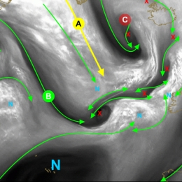
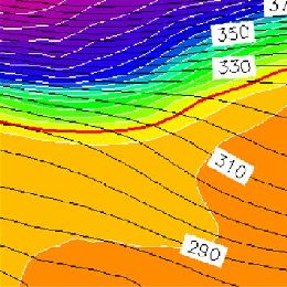
This module takes a closer look at vorticity maxima and minima signatures in satellite imagery.
Vorticity patterns control the circulation of air masses in their vicinity. By doing this they control the location of important meteorological quantities that are essential for an accurate diagnosis and forecast of the atmosphere.
The scale of vorticity patterns in the atmosphere ranges from large-scale synoptic system circulations (low and high pressure centres) to smaller meso-scale circulations (water vapour vortices (sometimes referred as WV eddies or WV eyes). The (anti-)cyclonic rotation in the atmosphere caused by a vorticity maxima is easily seen in satellite imagery. And quite naturally, satellite imagery is the key tool to correctly locate the maximum of cyclonic and anticyclonic vorticity in the atmosphere. Moreover, satellite images are able to show the small-scale vorticity patterns that are easily overlooked and smoothed out by a NWP model.
This training module has been developed to teach you to identify these vorticity centres in Meteosat Second Generation (MSG) satellite imagery. In addition the module will provide you with a firm physical background to help you understand why it is important to do a good diagnosis of satellite images and also provide you with a range of examples and exercises to demonstrate the impact a vorticity centre may have on your weather forecast.
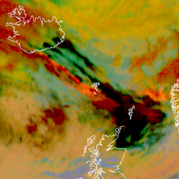
This module provides a guideline on how to assess the threat of volcanic ash. Therefore several tools based on satellite data can be consulted. Prominent examples are the Ash RGB or the use of IASI data.
Extreme weather conditions such the presence of volcanic ash can put aircraft navigation into major difficulties. If an aircraft encounters volcanic ash the navigation gets extremely challenging. Between 1975 and 1994 more than 80 jet airplanes were damaged due to unplanned encounters with clouds of volcanic ash. Seven of these encounters caused in-flight loss of jet engine power, putting the passengers lives at severe risk. Therefore the correct assessment of the weather conditions is essential to ensure save flight conditions. This training module is dedicated to forecasters/aviation forecasters. The main intention is to provide a guideline on how to assess the potential of hazardous weather events such as volcanic ash. For this purpose several tools based on satellite data can be consulted.
Training module on the detection of dust storms over Europe with various RGB images and products.
Atmospheric dust storms are common in many of the world's semi-arid and arid regions and can impact local, regional, and even global weather, agriculture, public health, transportation, industry, and ocean health. This globally-relevant three-hour module takes a multifaceted approach to studying atmospheric dust storms. The first chapter examines the impacts of dust storms, the physical processes involved in their life cycle, their source regions, and their climatology. The second chapter explores satellite products (notably dust RGBs) and dust models that are used for dust detection and monitoring. It also presents a process for forecasting dust storms. The third and final chapter of the module examines the major types of dust storms: those that are synoptically forced, such as pre- and post-frontal dust storms and those induced by large-scale trade winds; and those caused by mesoscale systems, such as downslope winds, gap flow, convection, and inversion downburst storms.
This training module was produced by COMET with the sponsorship and contribution of EUMETSAT and EUMeTrain.
Icing still represents a major threat to aviation. This CAL module focuses on the occurrence of icing in stratiform clouds. A method to detect icing probability from satellite images in combination with radar and radiosonde data is presented.
Ice formation on wings and inside of the jet engine of planes causes around 15% of weather related aircraft accidents. Most icing occurs inside cumulonimbus clouds when supercooled droplets freeze with contact of the aircraft body. But also in stratiform clouds icing represents a major threat to aircrafts during landing and take-off phase. In this CAL module, icing hazards related to stratiform clouds are examined. The introductory chapter focuses on the different types of icing and the physical principles leading to ice formation on aircrafts. Satellite products from geostationary and polar orbiting satellites help differentiating between ice and water clouds. A sample of satellite images and products illustrate this capability. Additional data sources like radiosoundings and radar imagery are useful completions to the satellite data. Interpretation of radiosoundings in view of icing occurrence is the main topic of chapter 4. The usefulness of radar data for detecting ice clouds is demonstrated. Three case studies complement the theoretical part of the training module, showing typical weather situations where severe icing represented a serious threat to aircrafts in the past. These case studies combine the above mentioned data sources in the frame of a practical situation. The CAL module finishes on a suggested procedure for nowcasting icing from stratiform clouds. Exercises offering the possibility to test the acquired knowledge form the end of this module.
In this CAL module you will learn to detect areas with the risk for Clear Air Turbulence (CAT). This will be done with the help of satellite images, soundings, flight reports and analyses of the airflow.
Clear Air Turbulence is one of the most frequent hazards for civil aviation. It is also one of the biggest challenges for forecasters to detect and warn for possible Clear Air Turbulence occurrence.
In this CAL module you will learn to detect areas with a high risk for Clear Air Turbulence (CAT). This will be done with the help of satellite images, soundings, flight reports and analyses of the airflow. Practical examples will show you how to apply your knowledge.
This CAL module deals with applications of MSG water vapour images in operational forecast departments. It focusses on the analysis of WV imagery in view of turbulence, cyclogenesis, convection and deformation zones.
This training module gives an overview on applications of MSG water vapour channels for operational weather forecasting. It handles the concept of potential vorticity which is a key feature to understand the dynamic processes in the higher Troposphere such as cyclogenesis. The CAL module also shows practical applications of the WV images from the geostationary satellites for locating tropopause foldings, clear air turbulence and deformation zones. It handles the effects of WV boundaries on the initiation of convective processes and finally presents some meteorological products heavily based on WV imagery.
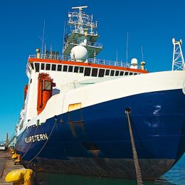
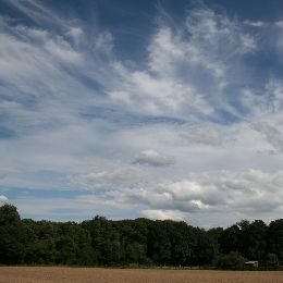
In this Training Module you can follow the voyage of the research vessel Polarstern across the Atlantic and observe various atmospheric phenomena.
Follow the voyages of the research vessel Polarstern through different climate zones and weather situations in three oceans - Arctic, Atlantic and Antarctic. Learn more about fog, winds and convection, the globel circulation and climate zones. See how satellite images help you observe the atmospheric phenomena.
In this Training Module you will learn more about the genesis and the development of cyclones at the downwind side of the Alps.
This training module treats the developement of cyclones at the downwind side of a mountain range with a special focus on the Alps. The module deals with the physical facts that lead to the creation of a lee cyclone, from its very beginning as a low-level vortex in the vicinity of a mountain range until its final stage as a mesoscale cyclone. The module tries to give an answer, why some of the lee vortices never develop into a full-grown cyclone and instead remain a local wind phenomenon or at best a low-level vortex that soon dissipates when leaving the downwind area by looking at the triggers that form cyclones. Local winds like the Bora and the Mistral are often linked to Lee Cyclogenesis in the Gulf of Genua. They will be treated at the end of the module.
Anna Cinzia Marra presents applications of the H-SAF precipitation products.
Length: 29 minutes.
The Mediterranean region is often impacted by heavy precipitation events, that are responsible for damages and sometimes casualties, especially over the coastal areas. Because of its peculiar geographical characteristics, conventional ground-based instruments, such as raingauge and radar networks, cannot be fully exploited for the monitoring, characterization and forecasting of severe events, in particular during their offshore development. For these reasons in the last decades satellite observations, both over geostationary and Leo platforms, have been recognized as a powerful tool to overcome the limitations of ground-based observations
In this presentation we analyze severe events that have recently affected the Mediterranean area, causing damages at the ground, and have challenged observational and forecasting capabilities. Heavy precipitation systems are described and analyzed here by exploiting active and passive microwave measurements and state-of-the-art precipitation products available in the HSAF project during the Global Precipitation Measurement (GPM) mission era. We highlight how the HSAF satellite products specifically developed for the European area, and thus tailored for the Mediterranean region, show better performances than algorithms designed for global application. We also show few strategies to blend satellite data and products with conventional meteorological data, with the aim to increase the knowledge of severe systems in the Mediterranean area and to support operational forecasting activities in a climate change perspective.
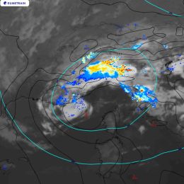
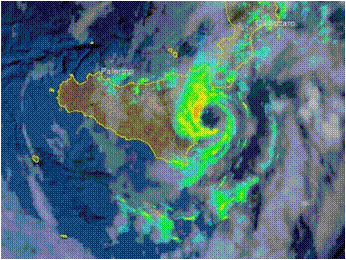
Jana Campa investigates the development and the impact of a convective situation on 8 June 2018.
Length: 42 minutes.
In early summer 2018 Central Europe was affected by several severe thunderstorms, many producing large hail. One of the most severe storms struck the town of Črnomelj, Slovenia. Interestingly, this storm did not look more severe in the remote sensing data than other storms on the same day. The presentation will investigate its development and impact. In addition, the preconvective environment of this and other severe storms of the last summer will be investigated with the help of satellite sounding data.
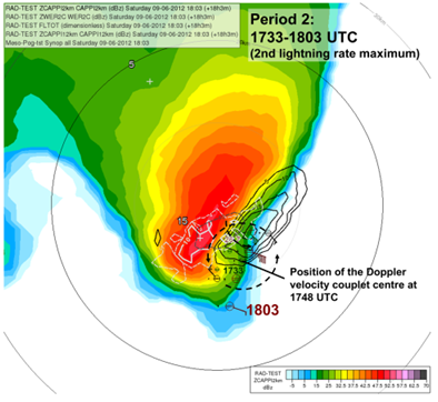
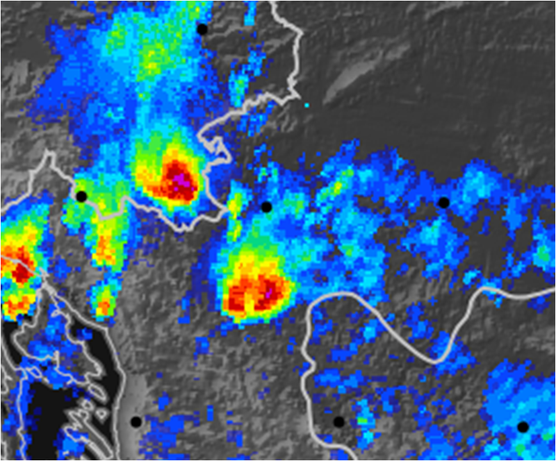
Maria Putsay analyses different convective cells with Radar and lightning data.
Length: 50 minutes.
Detailed analyses of various types of storms using remote sensing (satellite, radar, lightning), in-situ and NWP data will be presented. Five cases for thunderstorms occurring in the Carpathian Basin were studied. We tracked the storms, to analyse the storms' temporal and spatial evolution and to see the possible relationships between lightning characteristics and severe convection development.
One frequent feature of supercell storms was that stronger lightning activity occurred in periods of mesocyclone intensification. This was probably also related to higher speed of updraft (or higher vertical acceleration) in these cases. Also in multicellular storms could be shown that the storm dynamics has major influence on the lightning activity (the number of lightning increased when signatures of strong convergence appeared in the Doppler radar velocity, though the radar reflectivity was not very high in that period).
Moist and conditionally unstable environments generally support development of severe storm with high electrification. However, some cases show that the storm’s dynamics and microphysics (e.g. distribution and type of the ice particle growth) can lead to large variability. For example, we found a case with tornadic thunderstorm, which exhibited much less lightning activity compared to other severe storms, despite of favourable environmental conditions concerning moisture or instability
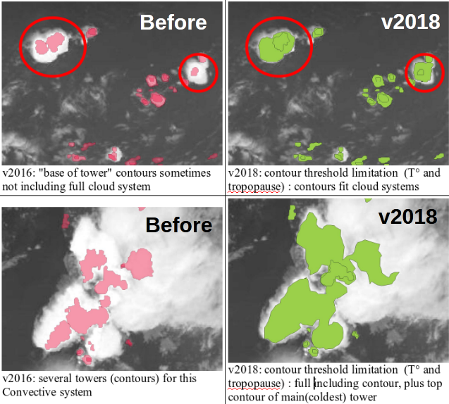
Jean-Marc Moisselin presents the most recent developments of the NWCSAF convection products.
Length: 30 minutes.
Météo-France develops and contiuously upgrades CI (Convection Initiation) and RDT (Rapidly Developing Thunderstorm) products. Both have been developed in the framework of NWCSAF.
CI is a pixel-based product that provides the probability for a pixel to develop in thunderstorm. The last delivery, v2018, has reached the "pre-operational" status in Eumetsat sense thanks to new developments (e.g. use of microphysics), tuning and validation effort. RDT is an object-based product that aims to detect, track, characterize and forecast the convective cells. Version v2018, includes new features like lightning jumps detection and is highly flexible and configurable. Status is "operational". RDT is very useful for aviation end users.