
NWP
Presentation 3 from the Synoptic and Mesoscale Analysis of Satellite Images 2016
Length: 61 min
Author: Andreas Wirth and Liliane Hofer (ZAMG)
When observing the development of frontal zones in satellite imagery, forecasters should always keep an eye on frontal sub-structures like upper waves, front intensifications or rapid cyclogenesis. It is important to look for frontal substructures, because they often show new developments. NWP models sometimes catch the situation, sometimes not. Especially for rapid or small scale developments, model performance may leave a lot to be desired.
Here we focus on comparison of model outputs and satellite data regarding frontal substructures. Because the data are easily compared and show great results, satellite images are a good tool for model output verification.
Presentation 2 from the Synoptic and Mesoscale Analysis of Satellite Images 2016
Length: 52 min
Author: Ab Maas (former KNMI)
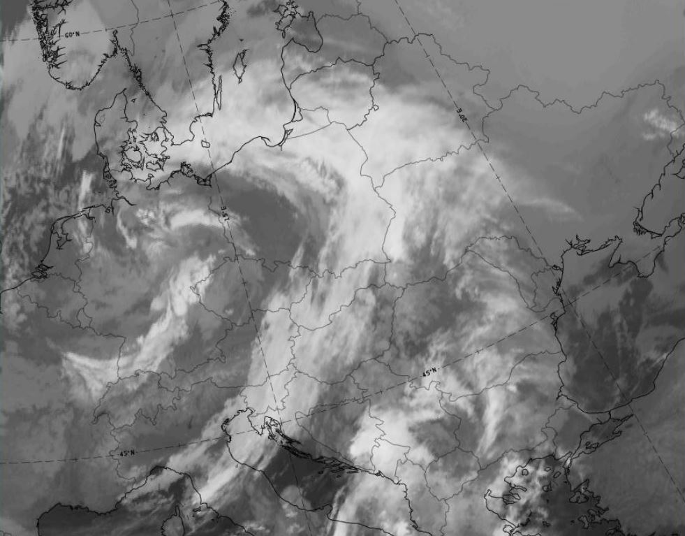
Fronts as described in the “Bergen school” by Vilhelm Bjerknes are early conceptual models. Parameters typical for the changing of air masses were named and used by forecasters to recognize transition zones (fronts) between air masses. Satellite information expressed how right Bjerknes was in his CM thinking, but this information showed also that fronts can have much more complicated structure and life cycle Bjerknes could imagine.
In SatManu there are 5 different types of cold- and 3 different types of warm fronts that are recognized and described.
In this lecture we concentrate on warm- and cold fronts and show how we can analyze them with help of CM thinking.
Presentation 1 from the Synoptic and Mesoscale Analysis of Satellite Images 2016
Length: 56 min
Author: Ab Maas (former KNMI)
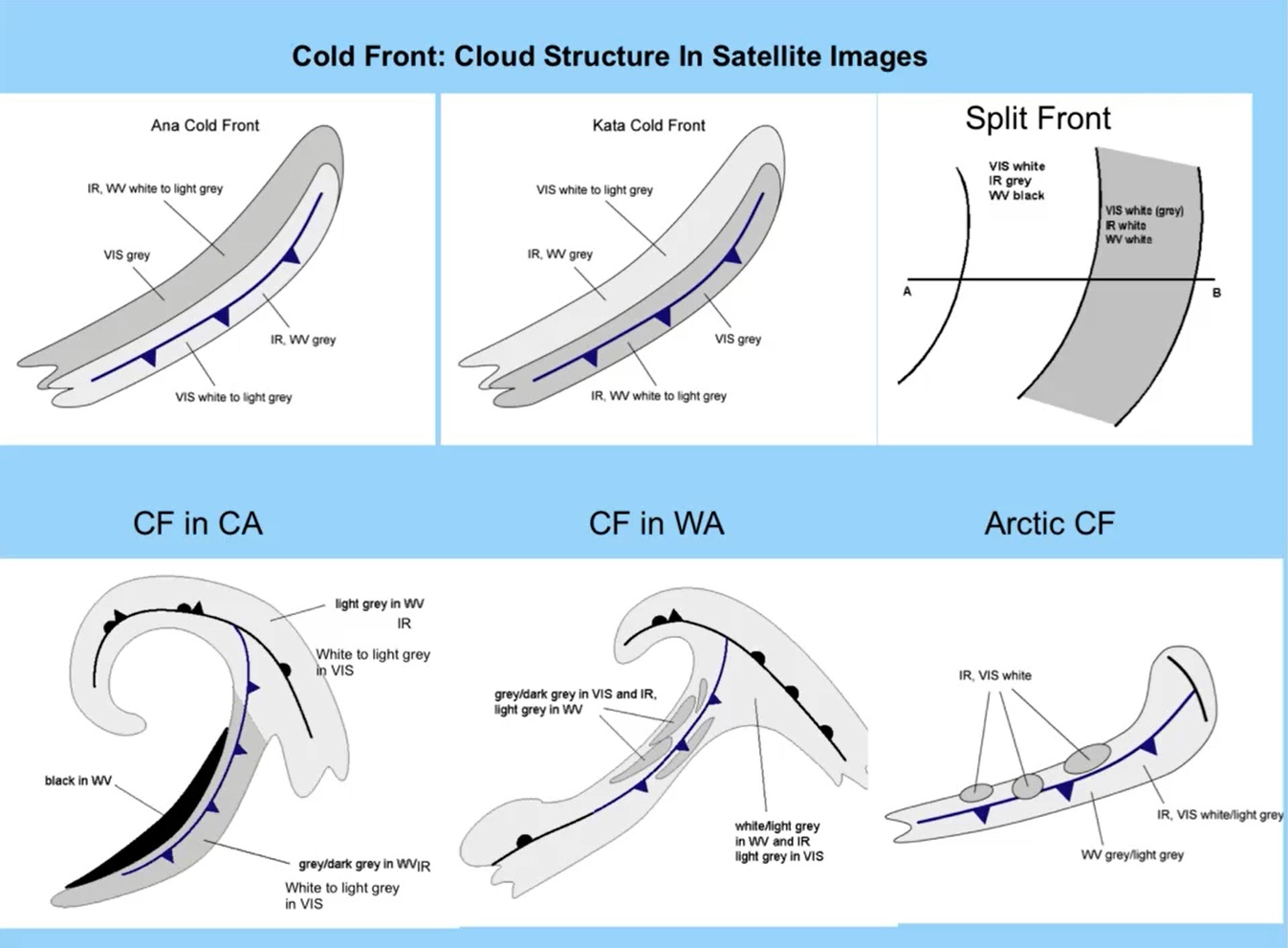
Getting a good, actual weather picture within short time is essential for a forecaster who has to react quickly and adequately on weather changing’s.
The huge amount of weather data which are available makes it almost impossible for a human being to handle. Thinking in conceptual models is the only way to deal with this problem
Meteorological satellites opened a whole new field in the conceptual model thinking in operational meteorology. Now there was an opportunity to recognize weather systems by detecting cloud patterns and verify this first guesses with observations and numerical parameters.
Within 20 years of the project fifty-three different conceptual models were described in a manual: Sat Manu. Also for the southern hemisphere, we have already fifteen CM’s described.
Presentation 11 in the Environment Event Week 2016
Length: 30 min
Author: Lee-Ann Simpson (SAWS)
South Africa is by nature a dry country, which has very short wet periods, mainly confined to the coastal areas and eastern half of the country. During the dry season, the hot, windy conditions result in a favourable environment for fires to spread uncontrollably and cause large scale damage to the local vegetation and to infrastructure. To be able to anticipate and forecast the risk of runaway fires in South Africa, a forecaster needs to have many sources of information, ranging from precipitation amounts to an understanding of the local vegetation. The inclusion of satellite imagery interpretation is an invaluable part of the forecasting process and the monitoring of fires can be done accurately and on a 24hour basis. This presentation will outline the risk the fires pose within South Africa and our forecasting processes dealing with this environmental hazard.
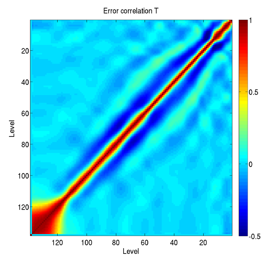
Kirsti Salonen talks about the assimilation of IASI temperature and humidity profiles at ECMWF.
Length: 53 minutes
ECMWF develops and operates a global numerical weather prediction system. Currently ca. 400 million observations are present in a 12-hour assimilation window; the vast majority of these are satellite measurements. The main approach to assimilate satellite measurements is radiance assimilation, and together with the conventional observations, they are the main drivers for the headline scores. Assimilation of satellite retrievals, such as IASI temperature and humidity retrievals, is an alternative approach for the radiance assimilation. During the lecture the main findings from a recent assimilation study with IASI L2 retrievals will be discussed. Assimilation experiments indicate that in clear sky conditions the humidity retrievals have a positive impact on analyses and forecast quality, comparable in magnitude to that obtained when IASI radiances are assimilated. However, the results are very sensitive to the diagnosed observation error correlation that is used. Assimilation of cloud affected humidity retrievals brings further improvements to model analyses and forecasts. Impact can be enhanced by using scene dependent observation errors and error correlations. Assimilation of temperature retrievals currently degrades analyses and forecasts, most likely due to smoothing of inversions and tropopause structures while the vertical sensitivity and resolution of the products are not yet taken into account in the observation operator.
Roland Winkler talks about rules and regulations that are in place at airports to provide passenger security in harsh winter weather.
The weather still has a major impact on aviation today. Weather forecasts in aviation not only support safety, but also provide important input on the subject of economical air traffic. As part of this presentation, I would like to give a rough overview of how air traffic works in the cold season. I will speak about de- and anti-icing of aircraft and the snow removal in the airside area. Finally, I will show which meteorological products are created to support safe and economical air traffic.
Ivan Smiljanić talks about the future possibilities detecting snow and ice from MTG data.
Detection of snow, but also its classification (depth, crystal size, age) depends mostly on the spectral and spatial resolution of geostationary satellites. Having better spatial resolution and more spectral channels, Meteosat Third Generation satellites (MTG) will be able to see snow better and tell more about its flavours, especially in the visible and near-IR spectral regions. Join if you are interested to know how the snow detection will be done with MTG and what is "the colour of the snow" with future data.
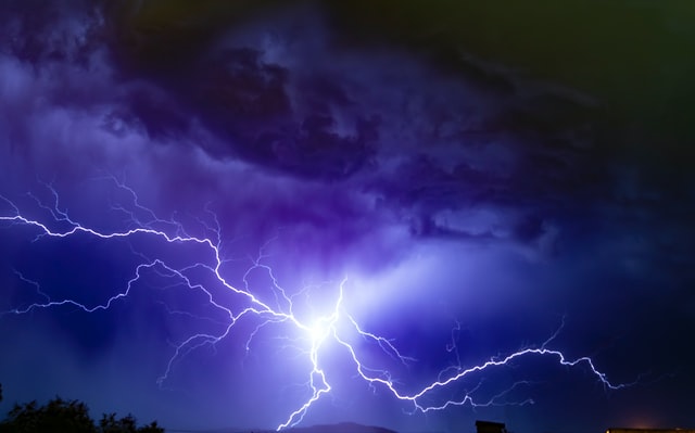
In this presentation Tomaš Pučik and Christoph Gatzen explore different regimes under which ingredients come together and create marginal CAPE setups typical of winter
Forecasting deep-moist convection and lightning in winter is challenging, partly because it occurs outside the typical season and partly because it forms in the environments characterized by marginal buoyancy. Despite weak CAPE, winter time convective storms often pose a considerable severe weather risk given their frequent collocation with strong vertical wind shear. In this presentation we explore different regimes under which ingredients come together and create marginal CAPE setups typical of winter. These include synoptically strongly-forced situations, elevated storms and the lake-effect over the European seas.