
Weather

This case study a polar low affected north-western Europe between the 27th and 29th of January 2004.
In this case a Polar Low affected North-western Europe between the 27th and 29th of January 2004. The Polar Low moved along the Norwegian coast then southwards in a northerly flow and turned over the North Sea in the direction of the German Bight. Eventually the Polar Low made landfall over the border between the northern parts of The Netherlands and Germany.
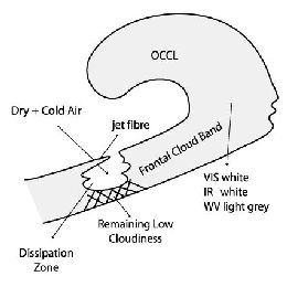
This case study discusses a front decay over central and northern Europe, the impact of CA and distinct sinking within a frontal cloud band.
Front Decay over Central and Northern Europe. The impact of CA and distinct sinking within a frontal cloud band is shown in detail.

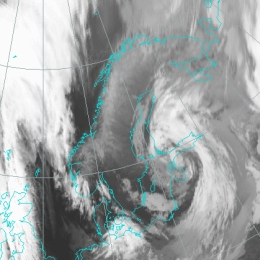
Storm Janika over Greenland, the Northern Atlantic and Finland.
From 10th to 16th of November 2001 a series of intensive storms moved over the Northern Atlantic and passed through Scandinavia and Finland to the east. A few of the storms were remnants of hurricanes but the one storm that caused extensive damage, at least to Finland, was of a smaller scale. It was named "Janika".
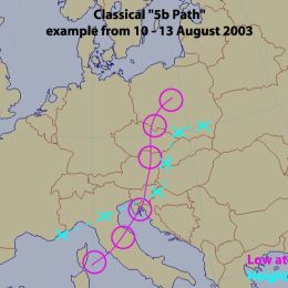
This catastrophic case describes two Mediterranean low pressure systems, propagating along a so-called 5b path.
In August 2002 two Mediterranean low pressure systems developed, taking a so-called 5b path. Such occurrences are rather unusual in summer as was the very rapid repetition rate of two events within about 8 days. The first event happened between 06 and 08 August, the second between 10 and 13 August.
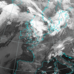
This case study discusses a Dark Stripe visible in water vapour imagery behind a Cold Front.
This case study will concern a Dark Stripe visible in water vapour imagery behind a Cold Front. This Dark Stripe indicates the presence of descending dry air, which can be of stratospheric origin. The stripe develops along the cyclonic side of the white water vapour band. Typical places of appearance of Dark Stripes are the rear of Cold Fronts and Occlusions, and the forward sides of Warm Fronts.

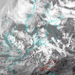
This case study deals with convective cells over Austria in a pre-frontal unstable airmass causing exceptionally intensive hail which is a rare phenomenon in this region.
This case study deals with convective cells over Austria in a pre-frontal unstable airmass causing exceptionally intensive hail and a tornado in Vienna which is a rare phenomenon in this region.

This catastrophic case describes the development of a Mesoscale Convective System starting in the Mid-Adriatic Sea and moving towards Bosnia and Herzegovina.
This catastrophic case describes the development of a Mesoscale Convective System starting in the Mid-Adriatic Sea and moving towards Bosnia and Herzegovina and then further NE. Heavy precipitation and flash flooding occurred in some Dalmatian towns, with severe hail inland.
The Cyclonic development of a Genoa low with associated with strong Bora winds is studied. During the development process the system also interacts with a cyclone over France.
The Mediterranean Sea favours the development of weak low-pressure systems. In many cases the development begins in or near the Genoa Bay in the mid Mediterranean. Cyclones then move either towards south-east, along the southern coast of Italy and end up in the eastern Mediterranean, or towards north-east, into the Adriatic, where in many cases they get stronger or trigger secondary cyclogenesis. However, once the cyclones are formed, they often produce periods of rainy weather. In this case the development started in the Mid Mediterranean and the cyclone moved north-east, into the Adriatic and was linked to high precipitation and strong bora winds.
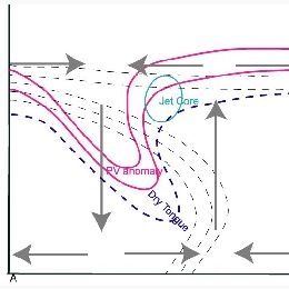
This case study addresses the unusual and rapid development of a small scale cold air feature into a synoptic scale frontal system.
A cyclogenesis is a rather complex process leading to an occlusion stage of a frontal system. There are at least two main theories: the classical occlusion process according to the polar front theory and the rapid cyclogenesis being a result of several processes where stratospheric and tropospheric features are acting together.
This case shows a very intensive development from a small scale comma to a synoptic scale cloud spiral. What makes this case so special is the fact that the cloud configurations are deviating from the usual development process of an occlusion spiral. Moreover the relevant NWP parameters demonstrate a situation with high potential for further developments.
A frontal cloud is being studied which moves over central Europe and is enhanced due to jet intensifications in the left exit region.
This case study presents an interesting case of frontal intensification caused by jet crossing. The intensification of the frontal cloudiness takes place when a jet streak approaches the frontal cloud band.
In the satellite images elongated cloud fibres often indicate the location of jet axis, whereas the intensification area is well recognizable through much brighter grey-shades within the frontal cloud band. The areas of intensification are usually chracterized by more intensive precipitation, often in shower form, sometimes accompanied by lightning.
This case study is about an unusual development of a super cell over the North Sea that is embedded in a warm frontal Wave.
The case from 09 June 2004 is an example of an unusual development of a super cell because it developed over the relative cool water of the North Sea and a second phase of intensifying occurred about 4 hours after sunrise over Northern Germany. Precipitation amounts up to 20 mm and gusts up to Beaufort 10 were registered.
An intense frontal zone extended from England to Eastern Europe. The Southern parts of the North Sea and Northern Germany were affected by its warmer edge. Near the passage of the super cell the radio soundings exhibited a strong vertical wind shear, potential instability between 1 and 5 km height and a tropopause at about 12 km with -64C.
The warm front was super-imposed by warm air advection and positive vorticity advection at the right entrance of a jet streak. That induced the development of a warm front wave. Within the potential unstable air during the evening of the 8th June a super cell developed near Scotland and moved after a temporary decaying and splitting till the morning of the 9th June to Hamburg. The right cell reached its maximum intensity at around 07 UTC.
Under influence of frontogenesis the development of two waves within a frontal system is being studied.
This case study addresses the development of two waves within a frontal system over Central and East Europe. Waves are substructures of a cold front which indicates the initial stage of (secondary) cyclogenesis.
For this investigation two different waves will be analyzed using single satellite images as well as combined channel products. Moreover conceptual models which base on a certain selection of numerical parameters will be introduced. Based on the development of the two different wave systems, the quality of the background information (satellite imagery, NWP-field) can be assessed.