
Weather
Presentation during the event week on Warning in October 2010.
Finnish warnings are issued on 24/7 routines via radio, television and www. Warnings are provided for general public, authorities and commercial clients. Warnings are issued for the next 24 hours in advance, but in future outlooks for some days in advance will be issued in near future. In weather situations where it is estimated that weather will be hazardous an extra forecaster monitors the situation and makes situation awareness reports for authorities. Also authority bulletins for general public are possible in severe weather situations.
Presentation during the event week on Warning in October 2010.
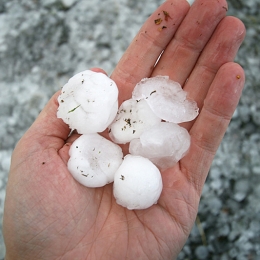
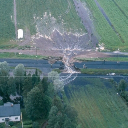
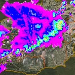
Rainfall warnings have not been issued in Finland until 2009. In the earlier years heavy rain forecasting was considered to be a too challenging task. However, growing demand for warnings together with some advancements in forecasts have changed this. Nowadays FMI provides warnings for the general public, authorities and commercial clients. In this presentation FMI's heavy rain warnings are presented and discussed.
Presentation during the event week on Warning in October 2010.
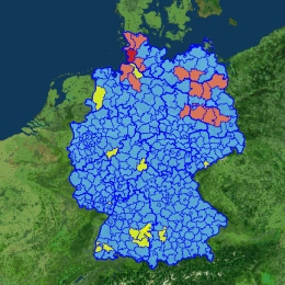
Instead of fixed warning thresholds, ZAMG has introduced the principle of annualities for their warning parameters. This decision was also chosen because most European NMSs also do it like this way. A yellow warning means that a situation exists only 17 times per year, which is an event which should be cautiously observed, but for which experience exists; an orange warning describes a situation which is only 3 times per year observed, therefore increased alert is necessary; a red warnng is an event which appears only 1 to 3 times per years and is therefore an extreme event.
Presentation during the event week on Warning in October 2010.
Presentation developed by Guido Wolz, Rolf Ullrich, Bernhard Reichert and Wilfried Jacobs on the warning system at Deutscher Wetterdienst (DWD). The issue of weather warnings by DWD is a task according to law. Especially if weather situations can cause danger for persons and material.
The warning management is split in 3 parts: Early warning in which information as possibility (very likely, likely possible) of significant weather situations on a national scale (250-700 km) from 2 day to one week. Pre-warnings in which severe weather situations on a regional scale (50-250 km) from 1 to 2 days is expected. Finally, rural district warnings where concrete warnings are issued for one or more rural district with a preliminary lead time; if necessary with differentiation of height levels.
Recorded powerpoint explaining what conceptual models and why we use them throughout.
A ten minute recorded powerpoint including audio and explaining you on what conceptual models are and why we use them in many of the training resources of EUMeTrain. The powerpoint also shows examples from Sat Manu and provides you the basis to go to satreponline.org and learn this technique in more details.
Presentation during the event week on Fog and Low Clouds in January 2009.
Vesa Nietosvaara presents fog forecasting process at FMI Aviation forecasting office.
Presentation during the event week on Fog and Low Clouds in January 2009.
Anna Eronn from the Swedish Hydrological and Meteorological Institute will talk about cold event Fog.
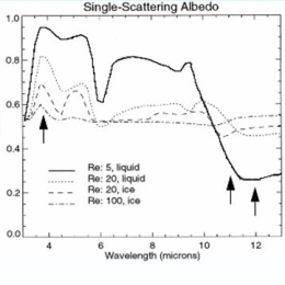
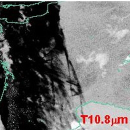
The most common way to detect fog and low clouds at night is by using of the brightness temperature difference between IR10.8 and IR3.9. Unfortunately this method does not work in very cold winter situations because the IR3.9 channel is very noisy for cold scenes. Therefore it is recommended to replace the IR3.9 with the IR8.7 channel which is significantly less noisy for cold scenes. The theory behind this and practical examples will be presented.

Presentation during the event week on Fog and Low Clouds in January 2009.
Nuno Moreira from Portugal will talk on how IM (Portugal) deals with fog, with focus in summer fog in comparison to (our) winter fog.
Presentation during the event week on Fog and Low Clouds in January 2009.
Herve Le Gleau (Meteo-France) will talk about the SAFNWC/MSG cloud type/height parameters. The algorithms, validation results, limitations and recent improvements (to be available to users in March 2009) will be presented and illustrated with low cloud/fog situations. An automatic use at Meteo-France of the NWCSAF/MSG cloud type for fog risk mapping will also be shown.
Presentation during the event week on Fog and Low Clouds in January 2009.
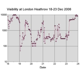
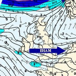
Jan Hemink from KNMI will give a practical session on fog in respect to the Aviation Meteorologist with an example from visibility observations and forecast of Fog at Amsterdam Airport Schiphol.
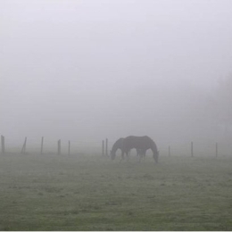
On a satellite image low layered Stratus is often compared to Fog. To actually know if there is Fog underneath this Stratus cover you have to know about the visibility. A problem than arises: When do we talk about Fog? The criteria for this is that the visibility should be below 1000 meters, but how do we defines this criteria during day and night.
The measurements of visibility in relation to the forecast will be a central point that is discussed in this presentation.
Presentation during the event week on Fog and Low Clouds in January 2009.
Paul de Valk, researcher of the remote sensing department at KNMI, will talk about radiation fog and shallow fog. Radiation fog is barely observable from satellite observations. Ground based observations are used to detect radiation fog. The satellite information is used to extrapolate the ground based point observations to a spatial distribution.
The forecaster is provided with information over fog favourable conditions deduced from observations and with information about visibility and ceiling. The tool is developed to support the forecaster in his decisions with respect to fog.
Presentation during the event week on Fog and Low Clouds in January 2009.
Practical session done by Stjepko Jancijev from the Croatian air-traffic control who will talk about Products and techniques used on Zagreb airport for fog forecasting. This talk will be followed by a colleague from the Croatian Weather Service DHMZ who will talk about the use of MSG and the derived Fog products in the operational shifts.