
Identify and interpret fields and derived products
José Lahuerta presents the NWCSAF products Convective Rainfall Rate (CRR) and CRR from cloud physical properties.
Length: 27 minutes.
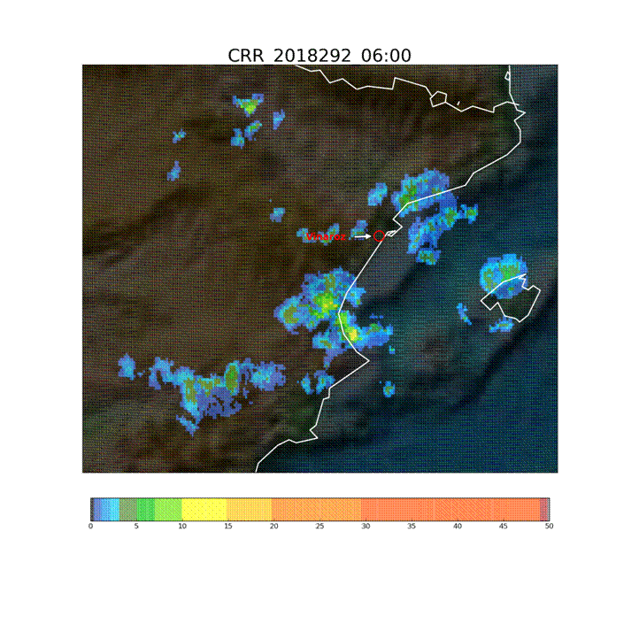
The Convective Rainfall Rate (CRR) and the Convective Rainfall Rate from Cloud Physical Properties (CRR-Ph) products are satellite derived rainfall products based on the MSG/SEVIRI channels and cloud top microphysical properties respectively. Both rainfall products have been developed within the NWC SAF context to provide with instantaneous rain rates and hourly accumulations associated to convective episodes. Last version of the NWCSAF software package includes a new version of the CRR-Ph for nigh time. CRR and CRR-Ph behaviour will be texted in different convective events.
Jean-Marc Moisselin presents the most recent developments of the NWCSAF convection products.
Length: 30 minutes.
Météo-France develops and contiuously upgrades CI (Convection Initiation) and RDT (Rapidly Developing Thunderstorm) products. Both have been developed in the framework of NWCSAF.
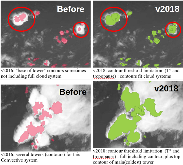
CI is a pixel-based product that provides the probability for a pixel to develop in thunderstorm. The last delivery, v2018, has reached the "pre-operational" status in Eumetsat sense thanks to new developments (e.g. use of microphysics), tuning and validation effort. RDT is an object-based product that aims to detect, track, characterize and forecast the convective cells. Version v2018, includes new features like lightning jumps detection and is highly flexible and configurable. Status is "operational". RDT is very useful for aviation end users.
Miguel Martinez presents the new NWCSAF products iSHAI and PGE00.
Length: 26 minutes.
iSHAI (imaging Satellite Humidity and Instability) is the clear air product of the NWCSAF/GEO software that allows the monitoring in clear pixels of several key ingredients in convection; in addition, it allows to identify the regions where the numerical models used as input do not agree with the observation of the satellite. In version 2018, iSHAI has been adapted to Himawari satellites and it is being adapted for GOES-R class satellites.
PGE00 is an AEMET complementary tool that performs first the vertical, temporal and spatial interpolation (4D interpolation) of the profiles from NWP to the projection and time of the satellite images; allowing to generate for all the pixels the same fields that iSHAI. Second, PGE00 can be used to generate synthetic satellite images using RTTOV-12.1 in clear and cloudy conditions with a high degree of realism using the ECMWF model at hybrid levels. In addition to the comparison with real satellite images, synthetic images can be used to generate new developments and for preparation of MTG era through the generation synthetic MTG-FCI and MTG-IRS images.
The NWCSAF products and services for the future MTG-IRS will be also briefly presented.
The lecture dels with the characteristics of satellites carrying instruments for measuring winds and with the logic behind the calculations of winds using satellites.
Length: 51 min
Author: Ad Stoffelen (KNMI)
The lecture deals with modelled winds and winds derived from instruments onboard satellites like Metop-A and Metop-B in low orbits around the Earth (polar orbits). Today's models are evolving at a rate that is faster than the increase of density of observations and that presents a problem for forecasts. Here stands the question 'Will meteorology continue to develop and improve?'. The lack of observed data is thus filled with the data from satellites, although this data also has its own constraints due to the way it is derived. In the lecture the characteristics of the satellites carrying instruments for measuring winds and waves will be explained and the logic behind the calculations of winds using satellites will be discussed.
David Fairbairn presents examples of downloading, converting the format to regular netCDF files and visualizing the data in Python.
Length: 19 minutes.
H-SAF root-zone soil moisture products are freely available online. They are currently stored in daily files on a reduced Gaussian grid in GRIB binary format, which increases storage efficiency. Examples of downloading, converting the format to regular netCDF files and visualizing the data in Python are presented. The new metview-python package is also introduced, allowing direct applications in GRIB format.
David Fairbairn discusses the theory behind the near-real-time and data record RZSM products.
Length: 25 minutes.
ECMWF provides the core root-zone soil moisture (SM) products for H SAF through an Extended Kalman filter assimilation system, running independently of the NWP system. Space borne scatterometer-derived surface SM observations are assimilated into the root-zone (0-1 m) SM of the H-TESSEL land surface model. In this presentation, the theory behind the near-real-time and data record products is discussed.
The presenters show examples for the use of SM data in identifying drought conditions in some regions worldwide.
Length: 25+14 minutes.
Satellite soil moisture (SM) products are highly suitable for monitoring agricultural drought. As satellite SM products cover long time periods and are available for large regions, the spatial and temporal analysis of drought conditions can be performed. The presentation will describe the theoretical background for performing drought analysis with satellite SM data, and will show some examples for the actual use of the data in identifying drought conditions in some regions worldwide.
Simone Gabellani and Fabio Delogu describe how soil moisture estimated trough satellite can be compared and validated with other sources of information.
Length: 38+39 minutes.
Soil Moisture is a crucial variable in hydrological applications. It can be measured and estimates in different way and along different spatial and temporal scale. The presentation describes how soil moisture estimated trough satellite can be compared and validated with other sources of information; theoretical basis and practical example will be showed.
Stefania Camica and Lucca Brocca describe the theoretical background for using satellite SM products in flood prediction.
Length: 19+24 minutes.
Satellite soil moisture (SM) products have been largely used for flood prediction. The knowledge of initial soil moisture conditions before a rainfall event is critical to determine the magnitude of a flood event. The presentation will describe the theoretical background for using satellite SM products in flood prediction, and will show examples for understanding the critical role of initial soil moisture for predicting floods.

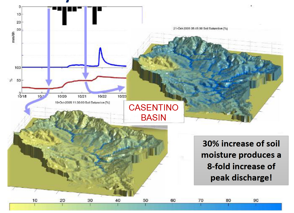
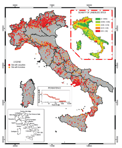
Nicola Berni presents the impact of soil moisture products for flood and land slide warning.
Length: 17 minutes.
Umbria Region Civil Protection Early Warning center (Central Italy) is in charge of alerting and monitoring critical events for Civil Protection purposes (mainly landslides and floods). In last ten years the office has used, in cooperation with national research institutes, satellite data to improve modeling/forecasting tools performances, monitoring activities about possible impacts of severe rainfall events able to trigger floods and landslides at regional scale. In fact, the estimation of the soil water content has proved to be a key parameter for better forecast models implementation both for landslide than for flood risk issues.
Silvia Puca presents how satellite products impact the efficiency of hydro-meteorological warning.
Length: 28 minutes.
Many severe meteorological events occurred in Europe during the last decade and caused casualties and damages to the historical heritage and natural environment. Protection of civilians and safeguard of the territory are the kay mandates of a civil Protection (CP) agency. This is achieved through activities that mitigate hydro-meteorological risks, such as flooding and droughts. European CP agencies, supported by meteorological and hydrological institutes, aim to assess risk scenarios, to monitor and supervise events and risk levels, providing early warning to National and local authorities.
Near real time accurate estimations of hydrological variables such as precipitation and soil moisture are invaluable to the CP agencies, enable them to issue early warnings and plan for disaster relief at the local level.
Besides measurements of key hydrological variables by ground-based instruments, often affected by a limited spatial coverage, advanced satellite-based precipitation and soil moisture products developed within different international programs as H SAF, are available and accessible to users in near-real time.
In this study, recent severe meteorological events are selected in order to understand how the main satellite product characteristics, i.e. accuracy, spatial pattern and resolution, update frequency and latency, impact the efficiency of a hydro-meteorological early warning system at a local level in an operational framework.
Jean Marc Moisselin presents methods to detect IWC from satellite data.
Length: 45 min
Author: Jean-Marc Moisselin (Météo-France)
Large amount of ice particle may cause erroneous aircraft probe measurement and damage aircraft engines. The ice crystals are generally located near cores of deep convection and associated cirrus anvils, at high altitude and in tropical areas. The understanding of the phenomena and its forecast are a key issue for aviation. There are several methods to detect clouds associated with ice crystal icing: MSG-CPP High IWC Mask, DARDAR, PHIWC, Alpha, RDT(detects and tracks convective systems).
A series of fields experiment in tropical regions have been conducted separately or conjointly by HAIC and HIWC projects. During HAIC campaigns, RDT has been provided on an operational basis through dedicated MétéoFrance processing chains. Qualitative and quantitative studies provided reasonably good results, especially in terms of probability of detection.
A new day-time attribute (adapted from MSG-CPP High IWC Mask algorithm) has been implemented in RDT v2016. Now RDT is produced globally by using five geostationary satellites, which in turn increased operational applications. New generation of satellites and the feedback on products performance will help to improve retrieval of the hazard and to define future research fields.