
Identify and interpret broad scale, synoptic and mesoscale systems
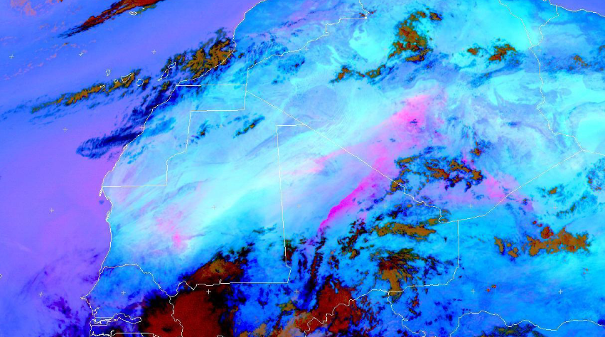
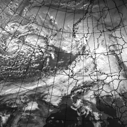
Hamidou Hama highlights the major socio-economic and environmental impacts of dust, focuses on the meteorological processes at various scales that are responsible for raising dust/sand storms in the arid Sahara Desert and the semi arid Sahel at its fringes.
Length: 40 minutes.
This presentation, after highlighting the major socio-economic and environmental impacts of dust, focuses on the meteorological processes at various scales that are responsible for raising dust/sand storms in the arid Sahara Desert and the semi arid Sahel at its fringes. The challenges facing the weather forecaster in forecasting such high impact weather phenomena and the importance of satellite remote sensing in their monitoring were also addressed here.
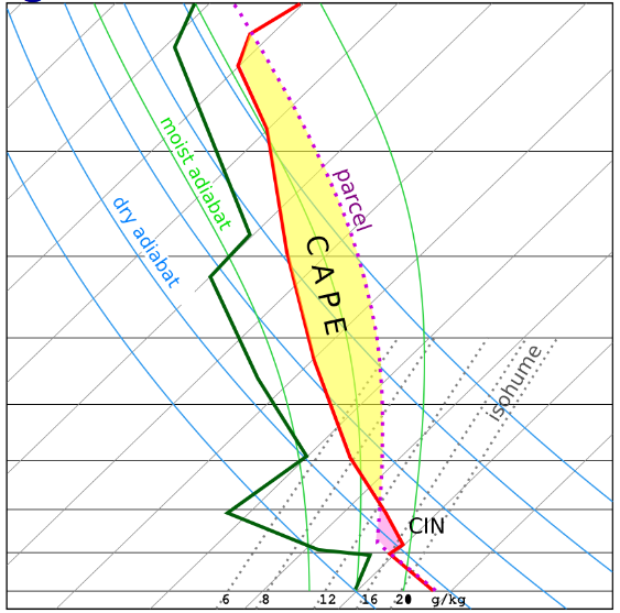
Helge Tuschy's talk offered an insight into the ingredients-based forecasting method, which assists an operational forecaster in preparing well ahead of an active thunderstorm day.
Length: 60 minutes.
This talk offered an insight into the ingredients-based forecasting method, which assists an operational forecaster in preparing well ahead of an active thunderstorm day. Mr. Tuschy also gave an overview about certain ingredients which could result in heavy rainfall and flash flooding (due to deep moist convection). He ended his talk with a short overview about ESTOFEX, the European Storm Forecast Experiment.
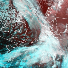
The presenter gives an overview into the mechanisms of convective lines connected to winter storms such as Emma.
Convective lines in connection with intense cyclogenesis hit Middle and Western Europe almost every winter season. These lines move very quickly and are often connected with thunderstorms, heavy gusts and graupel or even hail. In this presentation the related conceptual model and the preconvective environment will be explained. Based upon different satellite products and additional data two examples will be discussed.
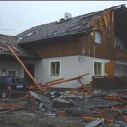
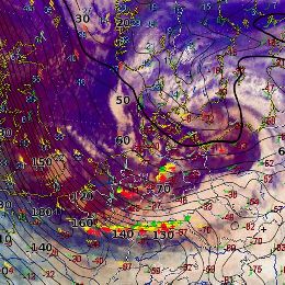
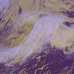
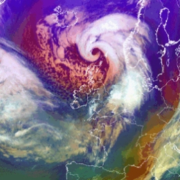
Presentation of Winter-Storm Emma which severely affected Central Europe with heavy downbursts and thunderstorms.
On 1 March 2008, the powerful late winter cyclone Emma caused widespread damage and claimed 14 lives in Central Europe. Embedded in the synoptic-scale storm field, deep convection along the cold front played a significant role in further enhancing the wind gusts. This presentation aims to unfurl an outstanding case of a rapid cyclogenesis, to match the events at the earth's surface with the storm structures seen in satellite and radar data, and finally to track down possible mechanisms which may have contributed to paving the way for one of the strongest downbursts ever documented worldwide.
The presenter analyses the mesoscale synoptic situation of medicanes from the past decades. He focuses on similarities in NWP fields.
The Mediterranean area can be affected by particular cyclones characterized by an unusual life cycle. This life cycle can be divided into two distinct parts: in the initial part the subject has a warm core and an asymmetric structure, which are typical aspects of a tropical storm. In the second part, it evolves rather like a cyclone of middle latitudes, usually explained by the classical theories; its origin is either on the sea as on the desert. These entities generally include extreme events, such as intense convection, strong winds and coastal storm surges; consequently, they assume a significant importance in the diagnostic and forecasting. This lecture will explain the energy contributions and the thermodynamic processes involved in the entire evolution, also describing the various significant aspects making use of adapted diagnostic procedures.
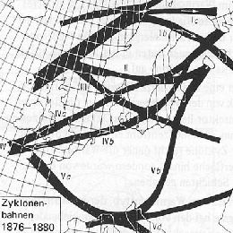
Kristian Horvath from the Croatian Met-Service focuses in his presentation on the different types of cyclogenesis in the Mediterranean Bassin.
The classification of cyclones and their tracks in the Mediterranean will be presented, with a special attention on the lee cyclones and their tracks when moving farther from the initiation area. Furthermore, the atmospheric ingredients at play during lee cyclone formation and development will be reviewed, such as the crucial role of the upper-level dynamical factors, but also the near-surface lee-side thermal or potential vorticity (PV) anomalies and surface fluxes, including their interactions with the orography and mutual non-linear synergies. In addition, the use of “PV thinking” will be demonstrated for easier conceptual understanding of the formation mechanisms. The results of numerical studies show that the intensity and track of lee cyclones are very sensitive to the details of the upper-level trough, such as its exact position relative to the mountain, the intensity and existence of sub-synoptic vorticity cores, which may result in reducing the predictability of lee cyclones in the Mediterranean area.
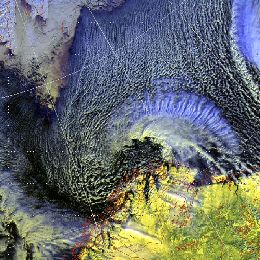
The presenter is senior forecaster at the Norwegian Met-Institute in Tromso. He refers on the synoptic aspects of Polar Lows.
The forecasting of Polar Lows is one of the most challenging tasks in weather forecasting in the arctic. The lecture will give a demonstration of basic forecasting methodology at the Norwegian Meteorological Institute, and show some typical signatures of the polar low as seen from satellite IR/visible imagery, from ASCAT and from other observational data. A climatologic survey is also given by the presenter.
Conceptual models are everywhere around us, even in our heads. Human brain as it is, can store lot of impressions but processing these informations can be a big problem.
Conceptual models are everywhere around us, even in our heads. Human brain as it is, can store lot of impressions but processing these informations can be a big problem. That is why we need conceptual models in everyday communication to know what do others even talking about. All the model data, satellite data, observations, radar data, etc. require good processing of one forecaster so he can cope with all this informations - that is where conceptual model fits in. Very chaotic processes in the atmosphere are today reduced to a smaller number of conceptual models, for the aim of better understanding of whole atmosphere. In this one hour presentation Ab Maas , is introducing manual of conceptual models called Manual of synoptic satellite meteorology (Satmanu). This project started in 1995 and until now there were more than 50 conceptual models described in it, still now maintenance and updating of new models is present. Some of the features and examples of conceptual models are brought in this lecture.
A weather front is a boundary separating two masses of air of different temperatures and humidity, thus different densities.
A weather front is a boundary separating two masses of air of different temperatures and humidity, thus different densities. They are often connected to a significant phenomenon such as showers and thunderstorms, and more generally to instability of the atmosphere. This lecture is based on two frontal structure types - Cold and a Warm font. In Satmanu there are five types or conceptual models related to Cold front; Arctic Cold Front, Cold Front (divided into Ana and Kata types), Cold Front in Cold Advection, Cold Front in Warm Advection and a Split front. Among Warm Front features there are; Detached Warm Front, Warm Front Band and a Warm Front Shield. In Satrep manual there are five chapters on each of above mentioned features; Cloud Structure in Satellite Images, Meteorological Physical Background, Key Parameters, Typical Appearance in Vertical Cross Sections and Weather Events. Ab Maas, will try to introduce these chapters to you, dealing with above mentioned types of Cold and Warm fronts.
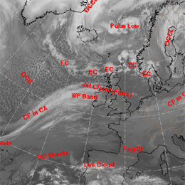
Presentation on how do occlusion cloud bands look like in different satellite images and which processes take place in the troposphere that lead to what we see.
This lecture is somehow extension of previous lecture in the satellite course, and is given by Dr. Veronika Zwatz-Meise. She is speaking about Occlusions. There are five features connected to them and these are; Back-Bent Occlusion, Cold Air Development, Instant Occlusion, Cold Conveyor Belt Type and a Warm Conveyor Belt Type of Occlusion. Presentation is constructed in a way that first there is an explanation of how do occlusion cloud bands look like in different satellite images. Question of processes that take place in the troposphere that lead to what we see in satellite images is also discussed. After that meteorological numerical parameters that describe the occlusion processes in a best way are observed (both on isobaric and isentropic surfaces). And at the end answer to a question "Which special developments at/with occlusion cloud bands take place during their life cycle?" are answered.
Presentation on the substructures in fronts and initial stages of cyclogenesis.
This one hour presentation on Frontal Structures, brought by Andreas Wirth from ZAMG, is following content of chapter called "Substructures in fronts and initial stages of cyclogenesis", from Satmanu manual. But not all features under this chapter will be discussed. Lecture starts with Front Decay and Front Intensification by Jet Crossing. These are two very similar conceptual models but they show the opposite effect. This is followed by Upper Wave and Wave. Presenter will show these two conceptual models together to see the differences or the common features between them. Finally, presentation finishes with Secondary Low Centres in Occlusion Cloud Bands, which is feature easy to detect and not very complicated conceptual model.
Presentation on Rapid Cyclogenesis and Instant Occlusion.
Two conceptual models from Satmanu manual are introduced by Barbara Zeiner from ZAMG; Rapid Cyclogenesis and Instant Occlusion. These are two kinds of cyclogenesis, but not the classical forms of an occlusion. In normal or classical occlusion there would be a broken wave in a polar front, but in this case we have somewhat different situation. In short, Rapid Cyclogenesis describes a very fast and intensive development of an Occlusion cloud spiral from a low level cloud head. Upper air processes are driving factors in such a development. On the other hand, Front intensification by jet crossing is development of thicker and mostly more convective cloud within a frontal cloud band in the left exit region of a jet streak during frontal crossing. All these processes in this lecture are supported by satellite images and lot of schematics from Satmanu Manual.