
Satellite skills and knowledge for operational meteorologist
Listed here are other resources related to Satellite skills and knowledge for operational meteorologist tag:
Note: click on an image to open the Resource
This presentation gives various applications of LSA SAF radiation products that we can find in four production areas for MSG satellite.
This presentation gives various applications of LSA SAF radiation products that we can find in four production areas for MSG satellite; Europe, Northern Africa, Southern Africa and Southern America. Firstly, variability (both seasonal and spatial) that we can find in albedo fields are discussed together with signatures, or features you can look for in LST fields. Relations between LST and vegetations, which comes from the fact that vegetation is controlling temperature by means of evapotranspiration are also shown here. Another application of radiation product is diagnose of various models via land surface temperature. At the end of presentation there are some words about long-wave and shot wave surface radiation budget, which are strongly influenced by clouds at seasonal scale.
Presentation on the physical principles and algorithms underlying the retrieval of Land Surface Temperature (LST) and emissivity from satellite observations.
The first block of this session presents the physical principles and algorithms underlying the retrieval of Land Surface Temperature (LST) and emissivity from satellite observations. Both geostationary, GEO (MSG) and low-orbit, LEO (Metop) satellite advantages and disadvantages are discussed. Emphasis of the presentation is on the methodologies used by LSA SAF for deriving these LST and emissivity products. The presentation also gives focus on the assessment of the uncertainty associated to the retrievals and respective validation is given.
Second part of this presentation is dedicated to algorithms used in the estimation of one of the components of the surface radiation budget - Down-welling Surface Long-wave Fluxes, i.e. DSLF. This product is derived from MSG SEVIRI instrument within LSA SAF. Problematics of firs 100m atmosphere long-wave radiation is also well discussed. Presented are examples and validation results that put into evidence the strengths and caveats of this product. Current Status and further developments (CDOP2) will follow.
Powerpoint: Land Surface Temperature
Powerpoint: Surface Radiation Budget
Presentation divided into three parts; general description of LSA SAF; applications of LSA SAF products ; and the way foward, i.e. perspectives of LSA SAF.
This session is a wrap up of all applications of the LSA SAF products, feedback from users (annual revision by technical and scientific review panels), lessons learned and roadmap for the next phase (2012-2017).
The presentation is divided into three parts; general description of LSA SAF; applications of LSA SAF products ; and the way forward, i.e. perspectives of LSA SAF.
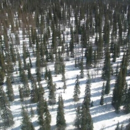
Presentation during the event week on Snow in January 2010.
Hannes Rieder from ZAMG, Austria who will provide a presentation on the interesting forecasting challenges associated with avalanches in Styria.
Presentation during the event week on Snow in January 2010.
Steinar Eastwood will present the operational Sea Ice products from the Ocean and Sea Ice Satellite Application Facility, both scientific and technical. Ongoing activities to improve the current products and develop new will be discussed and some examples of how the products are used will be shown.
Presentation during the event week on Snow in January 2010.
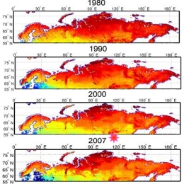
Jouni Pulliainen from FMI will present research results and snow products for climate research purposes.
Another speaker from FMI, Panu Lahtinen, will give a short overview of the four snow products being developed in the Eumetsat Satellite application facility on water management and hydrology (H-SAF). The ongoing developments on these products are discussed, and the future goals are shown. Also, some validation results will be shown.
Presentation during the event week on Snow in January 2010.
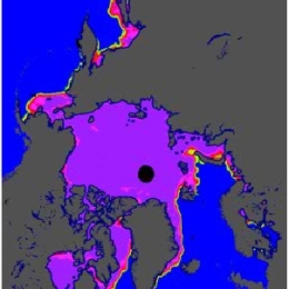
Niilo Siljamo (FMI, Finland) will introduce the snow cover product (SC) based on MSG/SEVIRI. He will describe the main parts of the algorithm with attention to various cases of snow cover.
In the second part, Nuno Moreira (IM, Portugal) will talk about snow products derived from MSG during the unusual snow events that have occurred in Portugal between November 2008 and February 2009.
Presentation during the event week on Snow in January 2010.
Izolda Marcinoniene will present a case study. According to Lithuanian criteria for meteorological phenomena it was a local-scale catastrophic event that affected the city of Nida, located on Baltic coast. Based upon the physical parameters of the atmosphere and the satellite information obtained, the situation was typical for Comma cloud. The main features and reasons for development of this catastrophic heavy snow event will be presented using detailed information such as vertical cross-sections, tephigrams and various satellite images.
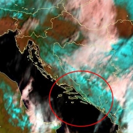
The second talk will be presented by Natasa Strelec Mahovic from the Croatian Meteorological Service (DHMZ). DHMZ will give a presentation on the forecast and analysis of heavy snowfall in Croatia in February 2009, when snow was recorded even on the remote islands in Southern Croatia!
Presentation during the event week on Warning in October 2010.
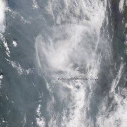
Presentation by Nuno Moreira (IM) and Andreas Wirth (ZAMG) on the exceptional summer of 2010 when a large scale crest was covering the two countries. As a result of the exceptional high temperatures and extreme low dew-point temperature the conditions were very dry. This resulted in a wide amount of forest fires. Within the high pressure and the lack of a governing flow the smoke caused many problems to Moscow.
Presentation during the event week on Warning in October 2010.
Presentation by the LSA SAF by Carla Barroso on the Fire Radiative Power product which was developed and is used by IM (Portugal) assessing the risk of forest fires.
Presentation during the event week on Warning in October 2010.
Presentation by Tanja Renko (DHMZ) who describes the warning system that was active in Croatia before joining the Meteoalarm. Then the decision process in giving a warning for Meteoalarm and the local authorities will be described using an example of a real warning case.
Presentation during the event week on Warning in October 2010.
Rob Groenland will look into more detail in the July 14th case of 2010. He will describe the meteorological part on the synoptic- and mesoscale. Furthermore he pays attention to the decision making process that finally lead to the issuing of a regional weather alarm for parts of the Netherlands that evening. Not only beforehand it is important the follow the procedures carefully but also in the aftermath it is essential to collect all the feedback and communication that took place between the expert- and weatheralarmteam but also from customers, end users and general public. Finally he shows you the results of an extensive KNMI damage survey that took place in the area of the most severe damage.