
Identify and interpret fields and derived products
Miguel A. Martinez and Maria Putsay give an overview on the NWC-SAF clear air products and their applications.
Since 2010, the PGE13 SEVIRI Physical Retrieval (SPhR) is available as an operational product of the NWCSAF/MSG software package. The algorithm is based on the physical retrieval algorithm for GOES developed by Dr. Jun Li (CIMSS at Wisconsin University) but using RTTOV as the radiative transfer model and the coefficients adapted for SEVIRI. The PGE13 has been optimized for the purpose of operational implementation; near real time images could be seen on the NWC SAF reference system (http://www.nwcsaf.org).
The improvements on version 2013 of PGE13 are presented first. The main improvement on the 2013 version is that it allows the use as the background NWP input of ECMWF GRIB files on hybrid levels; the 2012 version only allows the use as NWP input of GRIB files on fixed pressure levels.
This step is a small milestone in the exploitation of this kind of MSG L2 products. Now, the spatial and temporal resolution could be used together with vertical resolution provided by the hybrid levels GRIB files to get information of 3D structures. The reason it that the use of hybrid GRIB files as input to the algorithm avoids the stepwise aspect on the vertical cross sections created by the linear interpolation between too separated levels in the fixed pressure levels PGE13 version. Other point is that the local execution of PGE13 allows the generation of optional files with fields like 3D equivalent potential temperature arrays. Thus, forecasters can fully exploit the 3D structure allowing the detection of instability vertical gradients on medium levels.
All these changes allow forecasters the use of the PGE13 for a better monitoring of key ingredients in regions where likely triggering of convective storm could develop and also advise of the regions where the NWP disagree with the PGE13 physical retrieved profiles. The use of PGE13 in several case studies will be presented.
The NWCSAF Clear Air product consists of total and layer water vapour contents and instability indices. This product is retrieved from SEVIRI data for cloud-free pixels. As it can be calculated in 15-minute time step, even in 5-minute time step it is usable to monitor convection ability. Case studies will be presentation and analyzed: cases, when the NWP forecasted and the satellite retrieved convective environmental parameters are close to each other and when not. We will show selected cases when the NWCSAF Clear Air product has added value compared to the NWP forecast. The effect of the undetected clouds is also analysed.
As optional output the whole retrieved temperature and humidity profiles can be study. We show a case when the retrieved profiles were also analyzed. Statistical results will be presented on using the satellite retrieved Clear Air environmental parameters to separate stable from unstable environments and the environment where forming severe storm is not likely from the environment where it is possible.
Gunnar Noer gives a detailed presentation on the formation of Polar Lows, the climatology and forecasting methods.
Polar lows are small but fairly intense lows that develop during cold air episodes during the winter season in the marine Arctic. The lecture will address some of the basic formation processes, the climatology and traditional forecasting based on deterministic short range models. Recently, Polar Lows are tracked using fine scale EPS based on the UM, and presently the Harmonie 2,5 km model. Results are represented as an estimate of probability for PL tracks, wind and precipitation.
In this training module, you get an overview on the life cycle of Upper-Level-Lows and you will learn more about the impact on local weather.
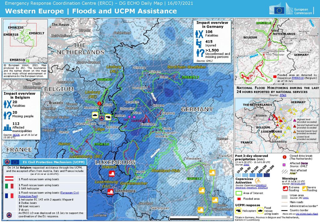
Upper-Level-Lows (ULLs) are a very common phenomenon in mid-lattitudes. They are usually associated with cold and rainy weather that can last for several days. When they remain stationary over a period of time, the can bring considerable amounts of rainfall locally. This synoptic situation has led in the past to floods and damages in infrastructure as will be show by the example of the Central European Flood in summer 2021.
This training module focusses on the meteorological aspects of ULLs, describes the life-cycle and throws a spottlight on the involved physical processes that accompany this meteorological phenomenon. Each stage of development is exemplified by satellite loops and corresponding NWP parameters. Exercises will help you to check the acquired knowledge.
Marianne Koenig gives a short introduction to some established methods to derive meteorological products from satellite data, including the benefits and downsides of products.
Length: 30 minutes.
The course gives a short introduction to some established methods to derive meteorological products from satellite data, including the benefits and downsides of products. Product examples will mainly focus on the MSG products, derived centrally at EUMETSAT and within the NWC SAF project.
Gavin Robbins presents the meteorological conditions that led to the largest coastal surge down the East Coast of England since 1953.
Length: 30 minutes.
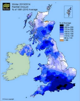
The winter of 2013-14 was the wettest for 250 years across England and Wales, with a succession of storms bringing sustained flooding from all natural sources, coastal, fluvial, surface water and groundwater. The presentation will start with an overview of the meteorological conditions that led to the largest coastal surge down the East Coast of England since 1953. The hydrometeorological conditions and flooding through late December 2013 to March 2014 will then be considered, along with examples and mechanisms of communicating the high impact conditions to emergency responders and Central Government. This included two briefings directly to our Prime Minister. Meteorological drivers and the possible teleconnections behind the exceptional conditions will also be considered.
Humberto Barbosa talks on the use of satellite precipitation products for mapping land slides in Brazil.
Length: 50 minutes.
Research during the past decade has documented the importance of satellite precipitation products to the overall workings of the tropical landslide susceptibility. Several types of satellite precipitation products are used for landslide assessment but the area they see, and the frequency of observations, varies. Two complementary types are particularly relevant to landslide management. Polar-orbiting satellites fly in a relatively low orbit (often at around 1000km above the ground), providing relatively high spatial resolution. But they only collect data over the same point once every few days. Geostationary satellites are positioned at a much higher altitude (about 36,000km). They orbit the Earth at the same speed as the Earth rotates on its axis, in effect remaining stationary above the ground and viewing the whole earth disk below. Their spatial data is much coarser, but is collected at the same point every 15 minutes. Moreover, rainfall-triggered landslides tend to be local-scale features, but ground conditions are also very important. When they destroy people's lives and livelihoods, they become natural disasters. Thus, Understanding the nature of spatial and temporal variability of rainfall events in developing countries is important to improve the landslide-prediction science. This seminar will present an overview of recent landslide examples in Brazil and applications of satellite precipitation products. A key satellite input dataset for the integrated applications is the EUMETSAT’s Satellite Application Facility on Support to Operational Hydrology and Water Management.
Giulia Panegrossi presents precipitation products and applications of the Hydrology SAF.
Length: 64 minutes
Within the EUMETSAT Satellite Application Facility on support to Operational Hydrology and Water Management (H-SAF), different precipitation products have been developed. The products exploit either measurements from passive microwave (PMW) radiometers on board polar orbiting satellites, or combination of Meteosat Second Generation (MSG) IR observations with the available PMW precipitation estimates. Some of the products are currently operational (http://hsaf.meteoam.it), and are available for near-real time precipitation monitoring and hydrological applications. Others are being improved and extended to satellites that have become recently operational [i.e., the polar orbiting Core Observatory of the Global Precipitation Measurement mission, (GPM), or the NPP Advanced Technology Microwave Sounder, ATMS)] or that will be operational in the near future (i.e, Meteosat Third Generation. MTG). The H-SAF precipitation products will be presented, focusing on the strengths, weaknesses, and potentials of the current products, and future perspectives offered by the products in development will be outlined.
In this presentation some applications of H-SAF precipitation products will be shown.
Nuno Moreira reports on a flash flood event on Madeira in 2010.
Length: 36 minutes.
During early morning and morning on 20th February 2010 an extreme and rare flash flood event has occurred in the Portuguese island of Madeira in the North Atlantic, causing 42 casualties, 600 homeless and an estimated loss of around 1000 millions euros. In this presentation, the synoptic environment will be presented and the precipitation producing systems affecting the island will be discussed. The analysis will be mainly performed using satellite imagery from Meteosat 9, both from singles channels and RGB images, as well as from objective estimates of rain and water vapor content. Results from following studies on the precipitation regime of this mountainous island will also be presented.
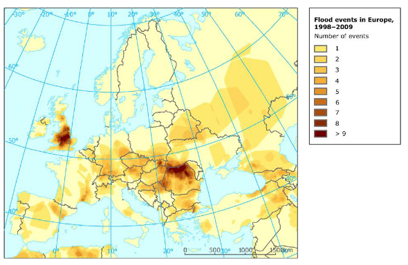
Natasa Strelec Mahovic investigates 5 years of flood events in Europe.
Length: 37 minutes.
In the last decade devastating floods occurred in Europe every year taking lives and causing great damages. In this presentation synoptic situations leading to the largest floods affecting Europe in the last 5 years will be analized. The main idea is to pinpoint the similarities and differences in synoptic patterns in order to improve the forecast of such events.
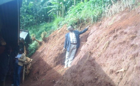
Joseph Kagenyi talks about forecasting land slides in Africa.
Length: 46 minutes.
The monitoring of weather characteristics over the equatorial and tropical regions is well covered with both polar and geostationary satellites hence the satellite becomes a very important instrument on severe weather monitoring and forecasting. The application of multispectral data of MSG in the monitoring the microphysics of clouds such as deep convective clouds with RGB composites provides in-depth understanding in the identification of regions where extremely active storms are located. The use of Multi sensor Precipitation estimate (MPE) also helps in the estimation total of accumulated rainfall on each region during the storm period. Such areas can easily be monitored and the possibility of excess rainfall within a day can be evaluated and such information is used to issue a warning for evacuation, or for support to the potential victims on these areas.
In short RGB composites, MPE Estimates, and the accumulated rainfall on daily basis becomes effective tools of landslide forecasting. We also add the NWP products particularly the High resolution (7 km) COSMOS data and NCEP CPC data as it gives a forecast with indications of possibly of heavy storms. However with satellite data you are able to ascertain which areas would the forecast show excess impact on the ground. The NWP products are used to help in creating accumulated rainfall values (estimates) necessary in establishing the threshold values for remote areas where station gauge data is not available.
Zuhal Akyurek reports on snow reflectance characteristics that have to be considered in snow detection from satellite data.
Snow on the ground differs from most of the Earth surfaces by its high reflectance or albedo in the visible and near-infrared wavelengths (0.350 to 1 μm). For longer, the snow’s reflectance decreases significantly. In these wavelengths,snow is even less reflective than certain types of vegetation. Most of the incident radiation in these wavelengths is absorbed in the snowpack. These unique spectral characteristics are used in optical remote sensing to distinguish between snow and other types of surfaces. The numerous validation studies indicate that the satellite snow products have large snow mapping accuracy with respect to ground snow observations for cloud-free conditions, which varies between 69 and 94% in the winter seasons. The main limitation of existing optical platforms operating at a daily timescale is cloud coverage, which significantly reduces the availability of snow cover information.
In this session, algorithms used to retrieve HSAF snow products; snow mask (H31, H34) and effective snow cover area (H32, H35) from opticalsatellite data are presented. The challenges and the opportunities in retrieving snow cover mapsfrom optical data are discussed.
Ali Nadir Arslan gave an overall introduction of the H SAF products with a focus on snow detection.
The operational goal of H SAF highlights the need to provide products with a reliable measure of their accuracy, so the potential users are made aware of the advantages and drawbacks of the use of the H SAF products in their operational activities. With this aim, within the H SAF, three Validation Groups have been established: one for precipitation, one for soil moisture and one for snow products.
An overview of existing and future satellite-derived snow products will be provided.