
Identify and interpret atmospheric phenomena
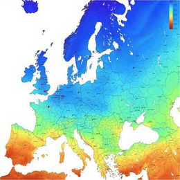
Land surface albedo quantifies the fraction of energy reflected by the surface of the Earth. As a corollary it then also determines the fraction of energy absorbed by the surface and transformed into heat or latent energy.
Land surface albedo quantifies the fraction of energy reflected by the surface of the Earth. As a corollary it then also determines the fraction of energy absorbed by the surface and transformed into heat or latent energy. Land surface albedo therefore is a key variable for characterising the energy balance in the coupled surface-atmosphere system and constitutes an indispensable input quantity for soil-vegetation-atmosphere transfer models. On the other hand, the down-welling surface short-wave radiation flux (DSSF) refers to the radiative energy in the wavelength interval [0.3 to 4.0 microns] reaching the Earth\'s surface per time and surface unit. It essentially depends on the solar zenith angle, on cloud coverage, and to a lesser extent on atmospheric absorption and surface albedo.
First presentation is devoted to an introduction of method retrievals for surface albedo and DSSF products that are implemented in framework of the LSA SAF in using MSG /SEVIRI observations. A second presentation will detail the validation exercise of these two LSA SAF operational products, which is based on inter-comparison with other satellite products, in situ measurements and outputs from NWP models.
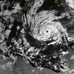
Lecture on unusual cyclogenesis taking place in the Mediterranean basin on 7 and 8 November 2011.
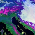
This case study took place in Mediterranean basin from 7th to 8th November 2011, with some interesting weather phenomena occurred there. It is shown that the sequential cloudiness type bands were; not organized convective system in the first step, then Comma feature in the next step, deep convection and finally occlusion. Because of confusing weather features connected to it, this weather phenomenon can not be classified as Tropical Cyclone nor as Rapid Cyclogenesis. The case is treated only from a synoptic point of view, using Meteosat-9 satellite images and ECMWF numerical fields from ePort web site and other graphical elaborations with Metview.
This presentation gives various applications of LSA SAF radiation products that we can find in four production areas for MSG satellite.
This presentation gives various applications of LSA SAF radiation products that we can find in four production areas for MSG satellite; Europe, Northern Africa, Southern Africa and Southern America. Firstly, variability (both seasonal and spatial) that we can find in albedo fields are discussed together with signatures, or features you can look for in LST fields. Relations between LST and vegetations, which comes from the fact that vegetation is controlling temperature by means of evapotranspiration are also shown here. Another application of radiation product is diagnose of various models via land surface temperature. At the end of presentation there are some words about long-wave and shot wave surface radiation budget, which are strongly influenced by clouds at seasonal scale.
Presentation on the physical principles and algorithms underlying the retrieval of Land Surface Temperature (LST) and emissivity from satellite observations.
The first block of this session presents the physical principles and algorithms underlying the retrieval of Land Surface Temperature (LST) and emissivity from satellite observations. Both geostationary, GEO (MSG) and low-orbit, LEO (Metop) satellite advantages and disadvantages are discussed. Emphasis of the presentation is on the methodologies used by LSA SAF for deriving these LST and emissivity products. The presentation also gives focus on the assessment of the uncertainty associated to the retrievals and respective validation is given.
Second part of this presentation is dedicated to algorithms used in the estimation of one of the components of the surface radiation budget - Down-welling Surface Long-wave Fluxes, i.e. DSLF. This product is derived from MSG SEVIRI instrument within LSA SAF. Problematics of firs 100m atmosphere long-wave radiation is also well discussed. Presented are examples and validation results that put into evidence the strengths and caveats of this product. Current Status and further developments (CDOP2) will follow.
Powerpoint: Land Surface Temperature
Powerpoint: Surface Radiation Budget
Presentation during the event week on Fog and Low Clouds in January 2009.
Vesa Nietosvaara presents fog forecasting process at FMI Aviation forecasting office.
Presentation during the event week on Fog and Low Clouds in January 2009.
Anna Eronn from the Swedish Hydrological and Meteorological Institute will talk about cold event Fog.
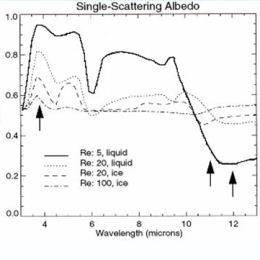
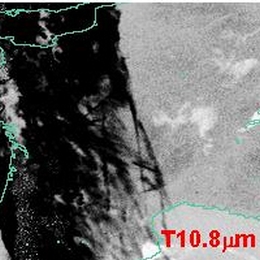
The most common way to detect fog and low clouds at night is by using of the brightness temperature difference between IR10.8 and IR3.9. Unfortunately this method does not work in very cold winter situations because the IR3.9 channel is very noisy for cold scenes. Therefore it is recommended to replace the IR3.9 with the IR8.7 channel which is significantly less noisy for cold scenes. The theory behind this and practical examples will be presented.

Presentation during the event week on Fog and Low Clouds in January 2009.
Nuno Moreira from Portugal will talk on how IM (Portugal) deals with fog, with focus in summer fog in comparison to (our) winter fog.
Presentation during the event week on Fog and Low Clouds in January 2009.
Herve Le Gleau (Meteo-France) will talk about the SAFNWC/MSG cloud type/height parameters. The algorithms, validation results, limitations and recent improvements (to be available to users in March 2009) will be presented and illustrated with low cloud/fog situations. An automatic use at Meteo-France of the NWCSAF/MSG cloud type for fog risk mapping will also be shown.
Presentation during the event week on Fog and Low Clouds in January 2009.
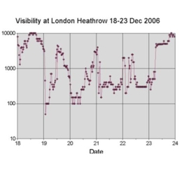
Jan Hemink from KNMI will give a practical session on fog in respect to the Aviation Meteorologist with an example from visibility observations and forecast of Fog at Amsterdam Airport Schiphol.
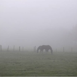
On a satellite image low layered Stratus is often compared to Fog. To actually know if there is Fog underneath this Stratus cover you have to know about the visibility. A problem than arises: When do we talk about Fog? The criteria for this is that the visibility should be below 1000 meters, but how do we defines this criteria during day and night.
The measurements of visibility in relation to the forecast will be a central point that is discussed in this presentation.
Presentation during the event week on Fog and Low Clouds in January 2009.
Paul de Valk, researcher of the remote sensing department at KNMI, will talk about radiation fog and shallow fog. Radiation fog is barely observable from satellite observations. Ground based observations are used to detect radiation fog. The satellite information is used to extrapolate the ground based point observations to a spatial distribution.
The forecaster is provided with information over fog favourable conditions deduced from observations and with information about visibility and ceiling. The tool is developed to support the forecaster in his decisions with respect to fog.
Presentation during the event week on Fog and Low Clouds in January 2009.
Practical session done by Stjepko Jancijev from the Croatian air-traffic control who will talk about Products and techniques used on Zagreb airport for fog forecasting. This talk will be followed by a colleague from the Croatian Weather Service DHMZ who will talk about the use of MSG and the derived Fog products in the operational shifts.
Presentation during the event week on Fog and Low Clouds in January 2009.
Jan Cermak (ETH) will talk about the operational detection of fog and low stratus from satellite data. The research presented my may help the forecasters and application experts to get out of the traditional thinking you cannot differentiate fog from low stratus with satellite images alone.