
Land
Overview on the H SAF satellite derived snow products.
Reliable snow cover extent is of vital importance to have a comprehensive understanding for present and future climate, hydrological, and ecological dynamics. Development of methodologies to obtain reliable snow cover information by means of optical and microwave remote sensing (RS) has long been one of the most active research topics of the RS community. Operational snow products namely H10 (Snow detection (snow mask) by VIS/IR radiometry), H11 (dry/wet by MW radiometry), H12 (Effective snow cover by VIS/IR radiometry AVHRR), H13 (Snow Water Equivalent(SWE)by MW radiometry), H31 (Snow detection by VIS/IR radiometry), H32 (Effective snow cover by VIS/IR radiometry AVHRR) have been developed since 2008 within HSAF. Considering different characteristics of snow for mountainous and flat areas, various algorithms are used in producing the snow products for flat and mountainous areas, and then the products are merged to have a single snow product. The development of new snow products is in progress. The presentation will provide an overview of existing and future operational satellite-derived snow products of H SAF portfolio. In the last part of the presentation, there will be a short introduction of quality assessment. After a brief recap of all available operational and pre-operational products, the performances of the products and the new validation strategy using high-resolution satellite data will be discussed, with some interesting case studies of the latter.
Lecture slides (Arslan and Akyurek)...
Giulia Panegrossi presents the challenges and recent advancements in satellite-based snowfall quantification and global monitoring.
Snow plays an important role in the Earth energy exchange processes, and is a fundamental element of the water cycle. The use of satellites for snowfall monitoring and quantification and for retrieving snow cover properties and variability is necessary to globally quantify water resources. Recent studies have evidenced how space borne multi-channel microwave (MW) radiometer measurements respond to both snowfall and snow cover properties. Improvement in both monitoring of high latitude precipitation and in our understanding on microphysical and dynamical processes that influence high latitude precipitation patterns, intensity and type must be driven by concerted observations of active radars and passive microwave radiometers. This has been recently demonstrated through the development of machine learning-based algorithms for snowfall detection and retrieval, exploiting global observational datasets built from passive and active microwave space borne sensors. In this presentation the challenges and recent advancements in satellite-based snowfall quantification and global monitoring will be discussed. Moreover, retrieval strategies based on machine learning approaches that are being adopted within the EUMETSAT H SAF in view of the future EPS-SG mission, will be presented.
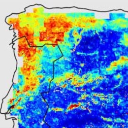
Semih Kuter talks about improvement of the EUMETSAT H-SAF H35 effective snow-covered area product by Multivariate Adaptive Regression Splines.
The pre-operational daily H35 effective snow-covered area product of H-SAF spatially spans the Northern Hemisphere and it is the successor of the operational Pan-European H12 product. Both products are at ~1 km resolution and developed through the H-SAF project of EUMETSAT by exploiting AVHRR channels. During the AS activity (i.e., H_AVS_18_03), an alternative machine learning-based approach is applied on H35 product to improve its accuracy. The new version of H35 product is realized through multivariate adaptive regression splines (MARS) algorithm. AVHRR reflectance data, as well as the well-known snow and vegetation indices (i.e., NDSI and NDVI), are used as predictors to generate the new MARS-based H35 product. The reference fractional snow-covered area (fSCA) maps are obtained from higher resolution Sentinel 2 imagery. Rigorous assessment on the final MARS-based H35 is performed over the Northern Hemisphere within a temporal domain from Nov 2018 to Nov 2019 by using i) Sentinel 2 derived reference fSCA maps, ii) ERA5-Land snow depth data, iii) MODIS MOD10A1 NDSI snow cover data, and iv) in-situ snow depth data. An additional visual assessment is also carried out by comparing MARS-H35/MODIS false-color and MARS-H35/Sentinel 2-derived reference fSCA image pairs over various geographic regions.
Filipe Aires presents statistical approaches to assimilate soil moisture information.
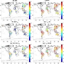
Land surfaces are characterized by strong heterogeneities of soil texture, orography, land cover, soil moisture, snow and other variables. These are very challenging to represent accurately in radiative transfer models, which currently still have limited reliability over land. In this study, we compare two statistical modeling approaches: the traditional CDF-matching used routinely in NWP centers (used here as a normalization and as an inversion technique), and the Neural Network (NN) methods. NNs and CDF-matching are compared and combined. Two cases are considered: (1) the more traditional inversion scheme, and (2) the forward modelling that could be attractive for assimilation purposes. It is shown that in the context of ASCAT, the inversion approach seems better suited than the forward modelling but this could be different for another type of observations. It is also shown that it is possible to combine the global model obtained using the NN and the localized information of the LSM offered by the CDF-matching. A first assessment is performed over the US using in situ soil measurements. Finally, we will present future plans to develop a forward operator for low-frequency microwave channels (SMOS, AMSR-E, SMAP, CIMR) based on a statistical modeling of surface emissivities over continental, snow-ice and sea ice surfaces.
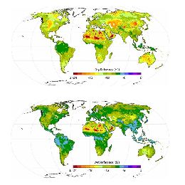
Emanuel Dutra presents an overview of the LSA SAF ET products with particular focus on the use of HSAF soil moisture in operations (H14 and future H26) and in the production of the climate data record (H141).
Evapotranspiration (ET) is a key component of the Earth System coupling land-atmosphere exchanges of water, energy and carbon. Due to the complex nature of the processes involved (radiation, boundary layer turbulence, vegetation status, soil moisture) it is very challenging to observe (locally and from Satellite) and to model. LSA SAF evapotranspiration product takes advantage of satellite radiation and soil moisture estimates to diagnose ET using a surface energy balance approach. This talk will present an overview of the LSA SAF ET products with particular focus on the use of HSAF soil moisture in operations (H14 and future H26) and in the production of the climate data record (H141).
Examples of downloading, reading, and displaying snow cover and snow water equivalent data in Python are presented.
H SAF snow cover and snow water equivalent products are comprised of either Near Real-Time (NRT), Offline or Climate Data Records (CDR), which are freely available at the H SAF data portal. Examples of downloading, reading, and displaying snow cover and snow water equivalent data in Python are presented.
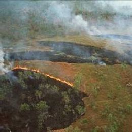
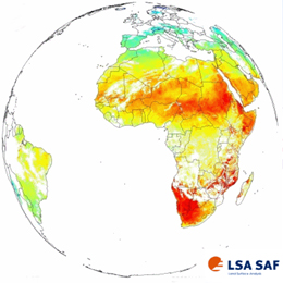
This webcast contains 2 presentations: The first is from Lourdes Bugalho who talks about the forest fire combined risk index (ICRIF) and the second presentation is from Renata Libonati about monitoring burnt areas from polar orbiting satellites.
First part:
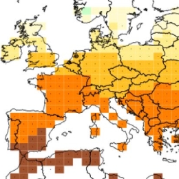
Forest fires are one of the most devastating natural disasters that often occur in mainland Portugal during the summer, with an impact on the economy, environment and climate. The Institute of Meteorology, currently Portuguese Institute of the Sea and the Atmosphere (IPMA, Instituto Português do Mar e da Atmosfera) has long made efforts to provide daily information on the risk of forest fires. Currently, IPMA daily runs an index of forest fire risk based on FWI (Fire Weather Index), developed by the Canadian Forest Service. This new index, ICRIF (Indice Combinado de Risco de Incêndios Florestais ) combines FWI with the type and condition of vegetation, called structural risk, being the vegetation type based on CORINE 2000 (CLC2000) and the vegetation conditions based on daily observation of NDVI (Normalized Difference Vegetation Index), retrieved from the AVHRR radiometer.
Second part:
Brazilian Amazonia together with the adjacent savanna (Cerrado) presents a huge number of fire events every year. In such context, accurate information about location and extent of burned area is required and of particular interest for the scientific communities dealing with meteorological and climate models in what concerns reliable estimations of biomass burned. Accordingly, an effort has been made by the scientific community to develop thematic products of burnt areas. In such context, this presentation will provide an overview of INPE/Brazil currently efforts in monitoring burned areas. The initiative is based on the (V,W) burned index. The index uses daily reflectance obtained from the 1km MODIS Level 1B calibrated radiance from bands 2 (NIR) and 20 (MIR). An overview will be given of results obtained and operational applications will be shown.
Go to Webcast (first part from L. Bugalho) ...
Go to Webcast (second part from R. Libonati) ...
Powerpoint (first part from L. Bugalho) ...
Powerpoint (second part from R. Libonati) ...
Sebastian Hahn from the Vienna Technical University talks in his presentation about the different sensors for the retrieval of soil moisture onboard polar orbiting satellites and describes the SM algorithm developed at the TU-Wien.
Although soil moisture represents only about 0.005% of the global water resources, it is one of the crucial variables in hydrological processes, influencing the exchange of water and energy fluxes at the land/atmosphere interface. For many environmental studies it is important to have accurate estimates of the spatial and temporal variations of soil moisture (e.g. hydrology, meteorology). Advances in satellite remote sensing have shown the potential of estimating soil moisture using various remote sensing techniques. This presentation will focus on an introduction using active and passive microwave remote sensing for the retrieval of soil moisture. In case of the active retrieval a detailed description of the semi-empirical model used for the METOP ASCAT soil moisture product will be shown step by step, especially highlighting assumptions and limitations. In the end various applications using satellite based soil moisture products will be summarised.
The scope of LSA-SAF is to increase benefit from Satellite (MSG and EPS) data related to land, land-atmosphere interactions and biospherical applications.
The main purpose of the Land SAF is to increase the benefits from MSG and EPS data related to land, land-atmosphere interactions and biophysical applications, namely by developing techniques, products and algorithms that will allow a more effective use of data from the two planned EUMETSAT satellites.
Although directly designed to improve the observation of meteorological systems, the spectral characteristics, time resolution and global coverage offered by MSG and EPS allow for their use in a broad spectrum of other applications, namely within the scope of land biophysical applications.
Activities to be performed within the framework of the Land SAF shall involve the development of products that are especially relevant in the following fields of application:
» Weather forecasting and climate modelling, which require detailed information on the nature and properties of land. Highest Land SAF priority should be towards the meteorological community and, within that community, NWP has been already identified as the one that has the greatest potential of fully exploit the products;
» Environmental management and land use, which require information on land cover type and land cover changes (e.g. provided by biophysical parameters or thermal characteristics);
» Natural hazards management, which requires frequent observations of terrestrial surfaces in both the solar and thermal bands;
» Climatological applications and climate change detection.
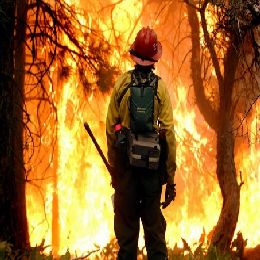
Lecture based on the detection of forest fire hot spots by satellite means, which is more important in regions with small population covered areas.
Forest fires, as a natural phenomena (e.g. ignited due to lightning), is important factor in natural living process of a forest. Nevertheless, problems occur because most of the forest fires are caused by a human action, thus are very difficult to predict in any form. Therefore this lecture is mainly based on detection of forest fire hot spots by satellite means, which is more important in regions with small population covered areas. Emphasis here is on the IR3.9 µm SEVIRI channel, which can be called window channel, but on the other hand it is close to a CO2 absorption band. The importance of this channel we can see through a Wien's law; 3.9 µm is peek wavelength of blackbody with temperature of around 750 K, which is very close to temperature of a fire flame during active phase of fire. Besides forest fire detection, in this lecture you can hear something about detection of aerosols coming from forest fires, identification of burnt areas and about Fire Risk products.
Lecture starts with explanation of Vegetation monitoring and some applications of Vegetation products, such as NDVI index, FVC index, LAI and FAPAR indices.
The new generations of sensors on board meteorological satellites (SEVIRI -MSG, ASCAT -EPS, etc. ) enabled a whole new range of products related to the properties of the surface. Applications of such products are great. Some of them are; Vegetation monitoring, Wild Fires detection, Floods and Heat waves monitoring, detection of Urban heat islands, Crop water requirements, etc.
Lecture starts with explanation of Vegetation monitoring and some applications of Vegetation products, such as NDVI index, FVC index, LAI and FAPAR indices. After that Evapotranspiration parameter and Reference evapotranspiration overview is given. And at the end Land surface temperature is observed and various applications of this product are discussed.
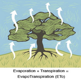
Evapotranspiration is a parameter closely related to vegetation state and stress. This session will show how this quantity is obtained within the LSA SAF.
Evapotranspiration is a parameter closely related to vegetation state and stress. This session will show how this quantity is obtained within the LSA SAF. Evapotranspiration is estimated using a land surface model forced with radiation and vegetation variables obtained from SEVIRI measurements. Very interesting Resistance scheme of this model is nicely explained using deviding image pixels into \'tiles\' of homogeneous vegetation types. Input and output of this model is also mentioned. Presentation is showing validation and incomparison of results together with possible applications of it.