
Upper Wave
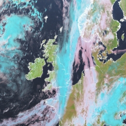
Upper Waves are cloud bulges at the rear edge of Cold Front cloud bands. They are associated with upper level processes and do not develop.
The term upper level refers to heights that are below the tropopause, but generally above 500 hPa. Wave developments in general take place within a Cold Front. According to the polar front theory a low pressure area in the lower levels of the troposphere can develop if a small-scale disturbance is superimposed on the stream field, causing an ageostrophic circulation within the baroclinic zone of the frontal cloud band. A Wave bulge is an indication of such a process. This circulation causes a fall in surface pressure, convergence, a maximum in temperature advection and an increase in cyclonic vorticity within the lower levels of the troposphere. However, in the physical background of an Upper Wave some processes can be distinguished from classical theory. The observed cloud bulge of an Upper Wave is a sign of a disturbance in the upper stream, but there is no corresponding and deepening pressure minimum at the surface. The dominating driving mechanisms in the upper levels can also be seen from a sharp and pronounced trough at 300 hPa leading to an increase of curvature vorticity. An additional reason for the release of relative vorticity is the right entrance region of the associated jet streak, supporting ageostrophic circulation at upper levels within the stream field.