
Convective cloud features in typical synoptic environments: Fair weather conditions
Competency Framework
WMO Satellite Skills
Application
Description
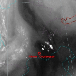
A preferred area for the initial development of deep convection is the boundary of Dark Stripes in the WV images.
Content
Analyses of satellite images and loops show that the first appearance of deep convection in fair weather conditions can be associated with the transition zone between relatively humid and dry air at levels above 600 hPa. Because of the absence of a frontal cloudband or any extensive cloud area this type of convection is called convection under fair weather conditions. Deep moist convection depends on the available moisture, conditional instability and a source of lift. This lift needs to be sufficient in order to move an air parcel to its level of free convection, initiating the process of deep convection.