
Weather
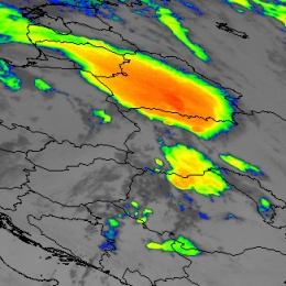
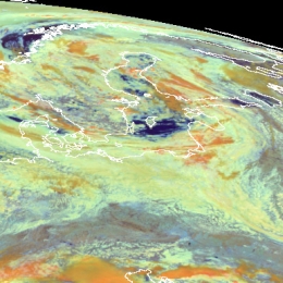
The case study describes two events of convection that occurred over Ukraine on 9th and 10th July 2004. Consequently heavy rain and rail were observed.
This case study addresses the formation of a mesoscale convective systems over the Ukraine on 9th and 10th July 2004 associated with heavy rainfall and hail. Cloud top temperatures of up to -70 degrees Celsius were observed. Moreover it should be noted that the Carpathian Mountains played a central role, since the mountain ridge triggered a set of cells.
In this study the development will be observed closely based on satellite imageries and the NWP-field. Since the vertical stratification is essential for the formation of convection, stability indices will be assessed as well.
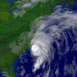
This is a case study on Extra Tropical Transition, the process by which a hurricane can change from a tropical cyclone to a mid-latitude depression.
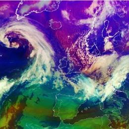
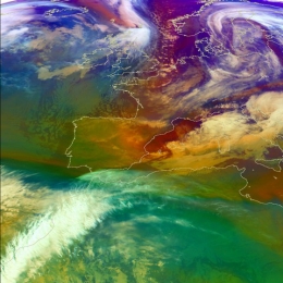
This study concentrates on the case of hurricane Alex as it progressed though transition zone and crossed the Atlantic as an extra tropical cyclone. Between 31 July and 6 August 2004 the hurricane reached the Outer Banks in North Carolina. At this stage his intensity was classified as category 1. Within the further movements the hurricane strengthened and reached category 3.
This study will introduce the concept of ETT and compare it to other conceptual models. Therefore several indicators from the satellite imageries as well as the derived numerical parameters will be analyzed.
This case study is about a typical formation of a squall line moving from France towards Germany.
During the 18th August a frontal cloud pattern moved from Western France to Central Germany. From noon until the evening this cloud pattern transformed into a squall line due to cyclonic vorticity advection induced by a short wave trough. From the afternoon to the evening a mesoscale low with negative surface pressure tendencies developed east of the squall line. In combination with the increasing temperature contrast between the front and rear of the squall line, the velocity of the wind reached 100 km/h. Gusts of up to Beaufort 9 (flat areas) and 11 (mountainous regions) and precipitation of about 30 mm over Eastern France and and Western Germany were observed.
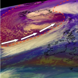
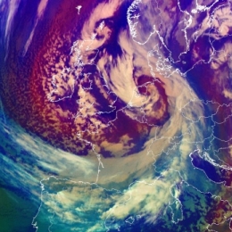
The interaction between an upper level PV anomaly and a tightening/sharpening baroclinic zone causes a Rapid Cyclogenesis with high windspeeds over Iceland.
In this study a development of a mid-latitude cyclone will be shown. The development takes place because of the interaction between an upper level PV anomaly and a tightening/sharpening baroclinic zone, which can be identified as a low-level PV anomaly. Mutual interaction takes place which eventually leads to a deep surface cyclone. What makes this case special is the fact that the surface cyclone does not show much displacement, especially during the deepening phase. This could be linked to the effect of the orography in Iceland and the fact that the upper level trough is quasi-stationary.
In this investigation the development of this system will be closely observed on the basis of satellite imageries and the NWP-field. Moreover the results will be linked to two conceptual models, namely Rapid Cyclogenesis and Upper Level Low.
A Rapid Cyclonegenesis reaches its maximum on 19 November 2004 in the Tatra Mountains.
In November 2004 a rapid cyclogenesis took place over central Europe. The cold front crossed central Europe in NW direction and brought intense precipitation in these areas. Strong gusts in Germany were restricted to higher regions. The storm reached its maximum on 19 November in the Tatra Mountains (Slovakia, southern Poland) where winds were orographically strengthened. On the lee side of the High Tatras, Wind speeds reaching about 80 to 100 kt in gusts were measured which had major impact on the environment.
The case study follows the development of a rapid cyclogenesis event with its origin over the Atlantic Ocean. Over central Europe an advanced stage of the Rapid Cyclogenesis can be observed. The mature stage is reached over Eastern Europe, represented by the development into a huge cloud spiral moving over Russia.
February 2005 strong Mistral winds caused a cruise ship to get into trouble. The cyclone that triggered this mistral and its further development are the central theme in this Case Study.
In this case the development of cyclone started in the Genoa Bay triggered by the strong north upper level flow. At the beginning of cyclogenesis the flow of the cold air was tunnelled through the Garonne Valley between the Pyrenees and the Massif Central and through the Rhone Valley between the Massif Central and the Alps. What makes this case special is the fact that the cyclogenesis was linked to a very strong Mistral over West Mediterranean during the whole period.
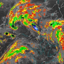
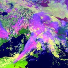
The case describes two convective events that happened end of May 2005 over Greece and Turkey and over Western Europe.
In the case study two types of convective development are observed and addressed. At the 30th of May a broad N-S oriented frontal zone is covering Western Europe. On the leading side of this front several convective cells emerge. A further index for frontal intensifications is the dry intrusion which can be detected in the WV imagery can be observed.
Apart from that several cells emerge in Greece and Turkey. The convective development in Greece and Turkey can be characterized as fair weather convection. In this case study it will be shown that both convective developments have similarities but also differences. Based on satellite imageries and derived numerical parameters these differences and similarities will be accentuated. However both weather events were associated with hail and lead to major damages in agriculture.
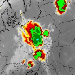
A classical example of prefrontal convergence occurred on 30 July 2005 as a long line of convective cells stretching over Central Europe developed.
On July 30th 2005 a prefrontal convergence line formed at the leading edge of a cold front. The long convergence line stretched from Italy over Austria into Poland and the Baltic States. Based on satellite imagery a sequence of thunderstorms could be observed. Moreover it should be noted that this form of prefrontal convergence is clearly linked to the diurnal cycle. As night sets in, most of the cells dissolve.
Since convection is a rather small scale phenomenon, it can be beneficial to address high resolution limited area models such as ALADIN-AUSTRIA. The comprehensive analysis of ALADIN-AUSTRIA revealed converging motions at 925 hPa and the divergence (e.g. outflow of air near the cloud top) at 700 hPa. In regard to the stability analysis the nowcasting tool GII (Global Instability Index) provided by EUMETSAT proved to be useful.
During the 9th and 10th July the Baltic States and Finland experienced heavy rain as a wave-cloud formed in moist and warm south-easterly air stream.
This study concentrates on two areas at the opposite sides of the low pressure area. The objective is to provide a detailed insight into the mechanisms that govern the formation of convection within a cold front (Finland) as well as prolonged rain within an occluded front (Lithuania).
In Lithuania the event was characterized by extreme rainfall (locally more than 250 mm in 3 days), leading to floods and severe damage. The south-westerly gusts on the 10th August caused uprooting of trees and further economic loss in excel of 45 million Euro. In Finland the most remarkable events were those connected with the passing of the cold front in the evening of August 9, associated with the intensive precipitation and lightning.
November 2005 severe snowfall had major effects in Western Europe. Snowfall caused an outage of power plants leaving people without heating and electricity.
The case study describes the merging process of a comma-like cloud feature with a cold front cloud band. The term instant occlusion is used because the mature stage of the development shows a cloud spiral similar to that of a normal occlusion. But the meteorological processes are totally different from an occlusion process where advection of cold air lifts warm air. The process took place in an area of cold air without a warm front being present.
The subsequent snowfall caused an outage of power plants leaving people without heating and electricity for several days.
This study illustrates an interesting case of a cold front in cold air advection on which two waves are developing. The origin of these waves is different which is explained.
This case study follows a cold front propagating from the Atlantic towards eastern Europe at the leading side of a deepening upper level trough. Special attention is paid to two waves developing on the cold front. Both of them show similar phases of development, from the first appearance of a cloud bulge to the formation of a cloud spiral.
The whole process can be observed in several types of satellite images: IR, WV and Airmass RGB composite. In the IR images the formation of the both wave bulges, intensification of the frontal cloudiness and cloud spiral development can be followed. The WV images enable the detection of the jet and the intrusion of dry stratospheric air. In the Airmass RGB the different air mass types as well as the position of the jet stream can be detected.
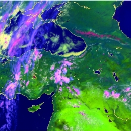
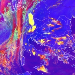
On 26th May the transition of a cold front trough Turkey was linked to serious convective developments. According to several reports the weather event was associated with hail.
The case study describes s series of convective developments which took place in front of a cold front as well as within the transition of that cold front. On 25th May first convective development were noticed over Romania at the leading edge of the front. Within the next few hours the convective developments started ahead of the front and were induced by orography.
During the night the convection was linked to the further movement of the cold front. The explosive convective development over Turkey on 26th May is nicely depicted in the set of radar-image and satellite images.