
Low level moisture in 0.9 micrometer band channels
Hans Peter Roesli showcases the usefulness and characteristics of the 0.9 micrometer band channels, one of which will be available with MTG satellites.
At the time of refining the FCI requirements for nowcasting applications, numerical forecasts had much difficulty in handling low-level humidity (low-level forecasts rapidly dried with increasing forecast time). This was one of the reasons why the expert team for nowcasting proposed to add in MTG’s FCI.a solar water-vapour-absorbing in the 0.9-micron region (now NIR 0.914 micron) alongside the clear NIR 0.865 micron band. Although nowadays operational numerical models have overcome the moisture problem, NIR 0.914 might still find valuable applications, in particular when accounting for the frequent imaging of the same scene in daylight.
MODIS includes a clear NIR 0.8585 band and 3 bands in the 0.9-micron region: 0.936, 0.940 and 0.905 micron, with decreasing water vapour absorption. Selecting NIR 0.8585 and the weakest absorbing NIR0.905 as proxy bands for FCI some meteorological situations were investigated, where low-level humidity monitoring could have been beneficial to nowcasts. MODIS flying on Terra and Aqua usually deliver two daylight overflights of the same scene, which allows for a rough appreciation of evolution in time.
Gao&Kaufman (2003) discussed the MODIS bands in view of the MOD05/MYD05 products for Total Precipitable Water Vapour. Based on their paper MODIS imagery of the reflectivity ratio 0.905/0.8585 was produced as a proxy for FCI. Taking the ratio is simple and damps further the (minor) differences in background reflectivity between the two bands. It was found that the ratio generally varies between 0.6 (humid boundary layer) and (dry boundary layer), as already given by Gao&Kaufman.
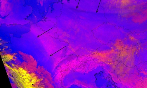
Examples under clear European skies will show situations of old frontal zones, convergence lines or north foehn. A more complex situation of low-level moisture advection under cloudy skies over the Po Valley affords the frequent FCI imaging, in order to get the full picture of the moist-air advection.