
greyish blue
Thin fog or low clouds over sea appear usually greyish blue or medium blue at mid-latitudes in the VIIRS Night Microphysics RGB images.
The Night Microphysics RGB is very sensitive to the thin mid- and high-level clouds. They typically have a distinct colour contrast both against thick clouds and cloud-free surface. However, in case of low clouds this is true only in special conditions. Such examples will be presented.
Thin fog/low clouds over sea may appear in many colour shades:
• The colour shade depends on the transparency of the thin fog/cloud, and on its microphysical properties.
• The colour shade depends on the colour of the low cloud.
• The colour shade depends on the colour of the underlaying surface.
---- Above bluish sea the thin water cloud usually appears greyish blue.
---- Above purple/pinkish sea the thin fog/low cloud above it contains more red shades.
• The colour shade of thin fog/low clouds depends on the cloud top temperature as well. Warmer cloud tops have more blue shade, colder cloud tops have less blue shade.
• In case of much colder fog/low clouds above warm sea, the thin part of the cloud will have a definite colour contrast both against sea surface and the thick part of the cloud. In that case the thin fog/low clouds usually appear medium (greyish) blue.
Below examples show these colour shade variations.
Thin fog/low clouds over bluish background (warm sea with not too dry atmosphere above) appear blue or greyish blue. In the presented cases the cloud temperature was close to the sea temperature: the sea surface brightness temperature (BT) was 15 - 19°C, while the cloud top temperature was 15 - 16°C.
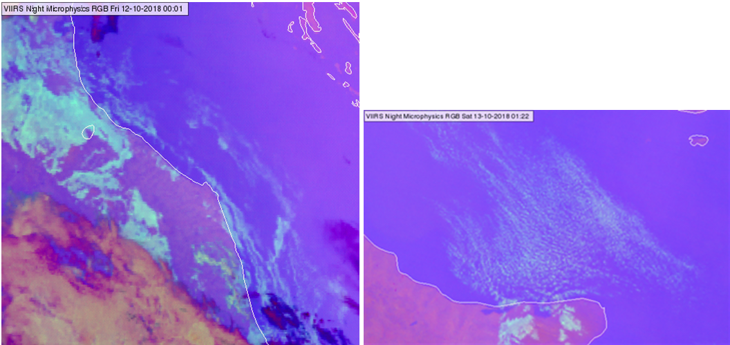
NPP, VIIRS Night Microphysics RGB image over the coast of Italy taken on 12 and 13 October 2018 at 00:01 and 01:22 UTC
The next image shows an example when the sea had more red shades (colder temperature or dry atmosphere above), and again the cloud temperature was close to the sea temperature (BT~10°C). In this case the thin fog/low clouds have more red shades, they may appear pinkish grey.
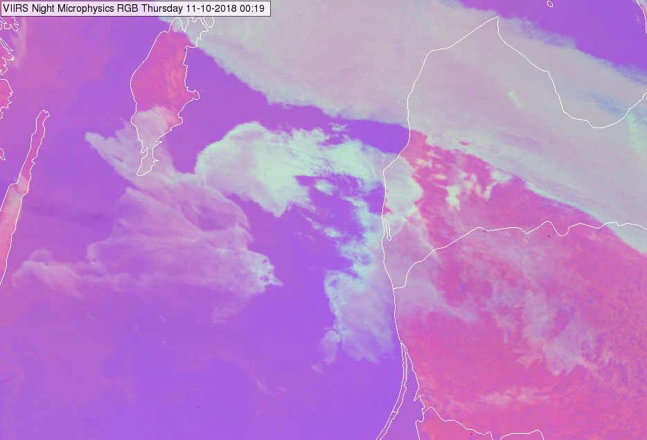
NPP, VIIRS Night Microphysics RGB image over coast of the Baltic Countries taken on 11 October 2018 at 00:19 UTC
The next images show examples of the special condition mentioned in the second paragraph, when the low-level thin clouds are best seen.
If a much colder fog/low cloud is advected above warm sea then its thin part usually appears medium blue or greyish blue with a definite colour contrast both against cloud-free sea and thick parts of the cloud (blue against purple, and blue against green of pinkish grey). In the examples below the sea BT was around 17°C, while the cloud top temperature was around 3-4°C.
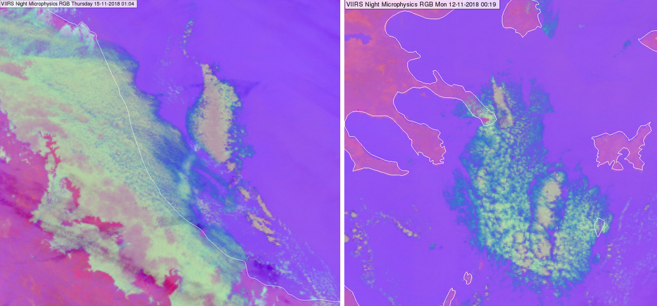
NPP, VIIRS Night Microphysics RGB image over coast of Italy taken on 15 November 2018 at 01:04 UTC (left) and over Greece and Aegean Sea taken on 12 November 2018 at 00:19 UTC (right)
A similar case is seen in the next image over the Black Sea. The sea BT was around 15°C, while the cloud top temperature was around 3-4°C.
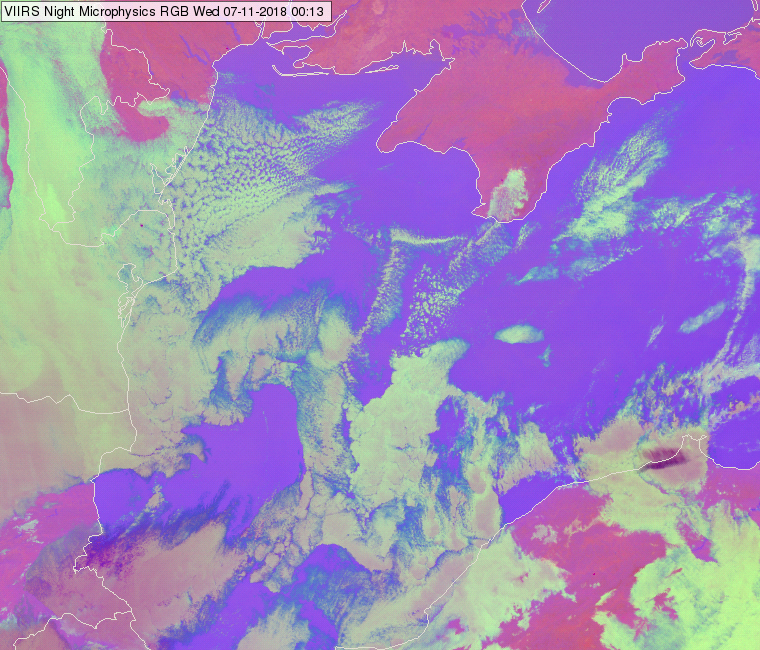
NPP, VIIRS Night Microphysics RGB image over the Black sea region taken on 07 November 2018 at 00:13 UTC
However, if the sea surface is cold then this effect is much weaker. In the example below the sea BT was between 1 and 4°C, while the cloud top BT was -6 to -8°C. In that case (high temperature difference, but cold sea) the thin part of the fog/low cloud will not have such a definite colour contrast against the sea and the thick part of the cloud.
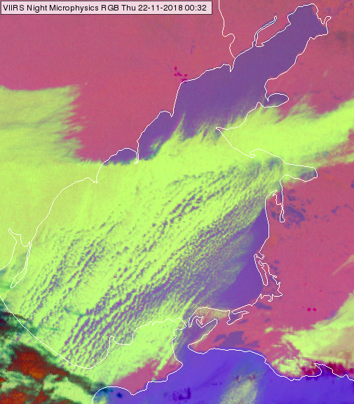
NPP, VIIRS Night Microphysics RGB image over Sea of Azov taken on 22 November 2018 at 00:32 UTC
Explanation of the colour of thin fog/low water clouds over sea at mid-latitudes in the Night Microphysics RGB (see the recipe):
In case of a thin cloud the measured radiance is a mixture of the radiance coming from below and the radiance emitted by it. Additionally, the BT differences in the red and green components decrease in case the thin fog/low cloud is much colder than the warm sea below it.
• In case the thin fog/low cloud is NOT much colder than the warm sea below it, the colour of the thin cloud will be a ‘simple weighted mixture’ of the colour of the sea and the colour of the (thick) cloud. (The weights depend on the transparency of the cloud.)
--- In case of bluish sea thin fog/low cloud usually appear bluish grey.
--- In case of pinkish/purple sea the thin fog/low cloud may appear pinkish grey or grey.
• If the fog/low cloud is much colder than the warm sea below, then the (IR12.0 - IR10.8) brightness temperature difference decreases and the red component will be less than medium strong. The (IR10.8 - 3.7) brightness temperature difference also decreases. In that case the thin cloud became greyish blue or medium blue with a distinct colour contrast both against thick clouds and cloud-free surface.