
Vegetation Recovery
Discussion is held on various techniques of mapping burnt areas from remotely sensed data, describing the main sources of errors and strategies to overcome them.
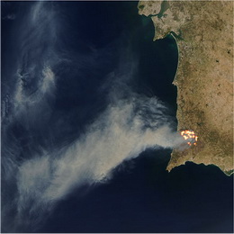
Discussion is held on various techniques of mapping burnt areas from remotely sensed data, describing the main sources of errors and strategies to overcome them. Focus of first part of this session is so-called Fire Detection and Monitoring (FD&M) product, which provides continuous monitoring of fire activity over Africa and Europe. This product relies on Fire Detection Algorithm called FiDAlgo (based on so-called contextual algorithms), is an operational procedure that allows active fire detection in near-real-time and is based on information from Meteosat-9, i.e. SEVIRI instrument.
The second part will present applications to the analysis of burnt scars and vegetation recovery, with case studies for the Iberian Peninsula. Operational product for tracking burnt areas LSA-SAF still doesn't have, but presentation gives perspective of rising such. Very simple model for post-fire vegetation recovery is presented and are shown correlations between post fire vegetation recovery dynamics and severity of fire damage.