
Sea Surface Height Variation
Competency Framework
WMO Satellite Skills
Application
Description
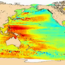
Sea surface height variation and mean sea level applications from radar altimetry.
Content
Radar altimetry satellites have been measuring the whole Earth’s ocean since 1991. Currently Jason-2, Envisat and Jason-1 are operational. Their main objective is the measurement of sea surface height variations. With a twenty-years long time series, the possibilities for climate studies are wide. We will describe roughly the data processing and uses, but mostly insist on two different applications: