Forecasts
As already mentioned in the abstract "the synoptic situation" the forecasters from ZAMG were highly aware of the potential from a possibly thunderstorm (weather report, 23rd of July, morning). The forecast for that day included the high probability of thunderstorms in the evening. Unfortunately the forecast did only mention the probability and did not state clearly the threat of thunderstorms. At that time the forecasters believed the severe weather would not hit Vienna because of the wind configuration. Of course there are many forecast products. In order to get an impression about the forecast situation that day it is recommended to look at different products.
ESTOFEX (European Storm Forecast Experiment) The European Storm Forecast Experiment is an initiative of a team of European meteorologists, meteorology students and trained enthusiasts, and serves as a platform for exchange of knowledge about forecasting severe convective storms in Europe and elsewhere. (www.estofex.at)
At 12 UTC a level 2 was issued for eastern France, most of Germany, northern Alps, western Poland and Czech mainly for large hail, severe wind gusts and tornadoes. Level 2 corresponds to a probability greater than 15% that a severe convective storm will occur within 40 km radius from a location. This is a significant threat that expresses larger confidence in the occurrence of severe storms. While severe weather phenomena are not part of the criterion, there is a slightly increased probability for these as well (3-5%).
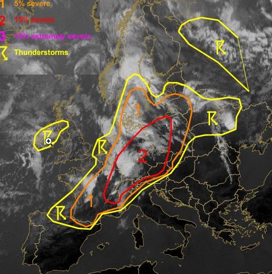
Figure 19: Meteosat 9 IR10.8 with ESTODEX overlay 1200UTC
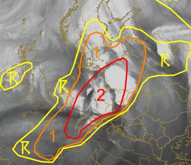
Figure 20: Meteosat 9 WV6.2 with ESTODEX overlay 1800UTC
In the red-marked area the threat of severe weather was as it turned out extremely high. The hail cells destroyed large areas in Germany (figure, Bavaria/Oberthal) and also in Austria (Braunau, Vöcklabruck). This picture also shows that a northward movement of the cell complex was expected. Therefore the east of Austria was not expected to get hit by fierce weather. Additionally to the homepage operated by ESTOFEX also offers a short weather discussion.
Here is a short extract:
The amplified long-wave through west of Europe experiences another strengthening as cold mid-level air spreads southward over the Atlantic and the very strong jet streak still intensifies while curving around the troughs base and spreading into western Europe. Downstream a short-wave trough accelerates eastward and crosses France, Germany and Poland during this morning. At lower levels, a cold front will move across France, Benelux and north-western Germany in the morning hours. To the south-east, models indicate frontal waves as very warm air masses spread north-eastwards. Strong instability will likely develop in the warm air advection regimes during the period and another outbreak of severe weather becomes likely.