
pink

Thick ice clouds are depicted in red or yellow colours in the Severe Storms RGB images. In the areas where the particle size is small and/or the cloud top is very cold it appears yellow.
The high level lee clouds are very cold and consist of very small particles. (Homogeneous freezing processes at very low temperatures typically lead to the formation of very small ice particles. Furthermore at the height they form the available humidity is rather low.) As a consequence the thick part of the high level lee cloudiness usually shows up in bright yellow colour tones. The thin parts are pinkish.
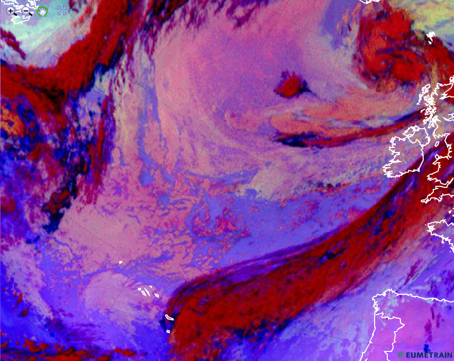
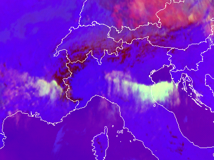
The image below shows a Severe Storms RGB image. High level Lee clouds are seen south of the Pyrenees and Cevennes. The bright yellow colour indicates the presence of very small ice particles.
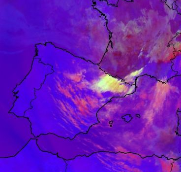
Meteosat, SEVIRI, Severe Storms RGB image for 17 May 2007, 10:10 UTC
The next image shows high level lee clouds formed over several mountains: the mountains of Corsica, the Apennines, the Dinaric Alps and the Carpathian Mountains.
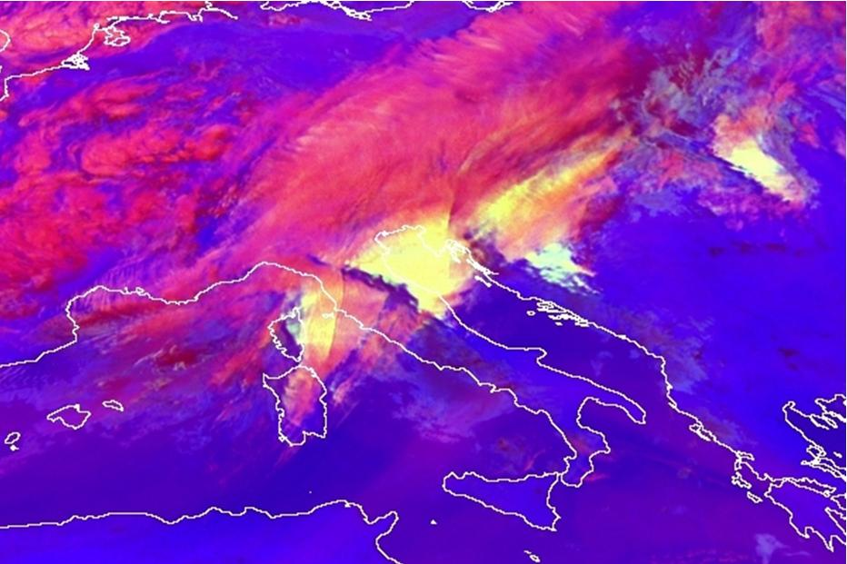
Meteosat-8, SEVIRI Severe Storms RGB image from 19 March 2007, 08:00 UTC
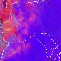
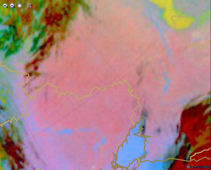
The image below shows high level clouds south of the Alps over Italy and Adriatic Sea. East of the Alps over France we see also high level lee clouds. Note that in this case the lee cloud is rather whitish than yellow.
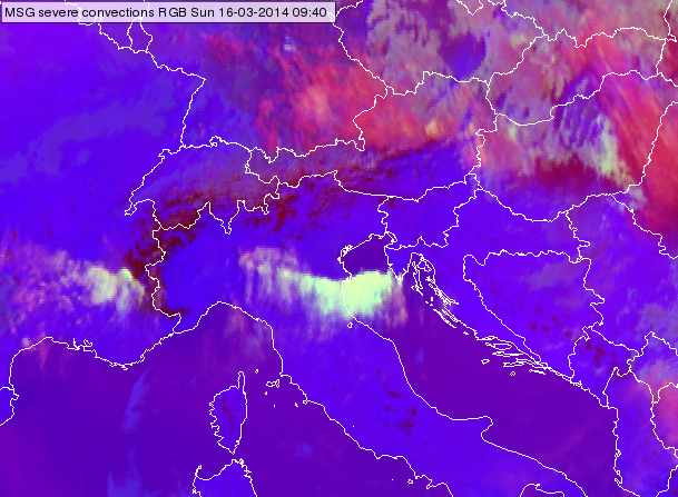
Meteosat SEVIRI, Severe Storms RGB image from 16 March 2014 09:40 UTC
Explanation of the colours of thick high level lee cloud (see the recipe):
• The difference (WV6.2 – WV7.3) is usually negative, but for thick high ice clouds it is around zero resulting in intense signals for the red colour beam.
• The difference (IR3.9 – IR10.8) is large because the cloud top is very cold and it consists of small particles resulting in intense signals for green colour beam.
• The difference (NIR1.6 – VIS0.6) is usually negative for ice clouds (much lower reflectivity around 1.6 than around 0.6 micrometer). However, if the particles are small the NIR1.6 reflectivity increases resulting ‘considerable’ signal in blue colour beam. If the ice crystals are extreme small the signal may become high.
As a consequence the signal will be intense in the red and green colour beam and also ‘considerable’ in blue colour beam. It is the difference of the (NIR1.6-VIS0.6) channels which determines whether the resulting colour will be bright yellow or in extreme cases whitish.
Note that small ice crystals may form not only in high level lee clouds. Small ice crystals can as well be observed: on top of storms with intense updraft, on the tops of storms with cold (high) cloud base and on the tops of polluted thick ice clouds.
Mid-level clouds depict in pink colours in the Night Microphysics RGB images.
The BTD (IR12.0 - IR10.8) responsible for the red colour beam is near zero on a scale reaching from -4 (dark) to +2 degrees (intensive red). Hence, the red colour contribution has an average value.
The green colour beam is of varying intensity depending on the thickness and the hight of the low cloud layer. The higher the cloud layer, the smaller the BTD (IR10.8 - IR3.9) and herewith the green contribution.
The blue colour beam is contributing with an average value. The warmer the low cloud is, the more the radiation from IR10.8 is contributing to the blue colour intensity and vice versa.
The pink colour results from a dominating red colour contribution mixed with average blue and a little green in case of mid-level cloudiness (see image below).
Night Microphysics RGB from 29 August 2015, 00:00 UTC
Explanation of the pink colour of mid-level clouds in the Night Microphysics RGB (see the recipe):
• In case of mid-level clouds, the red colour beam dominates slightly over the green and blue colour beam.
Semitransparent ice clouds are typically pink in the Severe Storms RGB images.
The images below show semitransparent ice clouds over the Black Sea and Ukraine and ahead of a front over Serbia, Romania, Ukraine and Belarus.
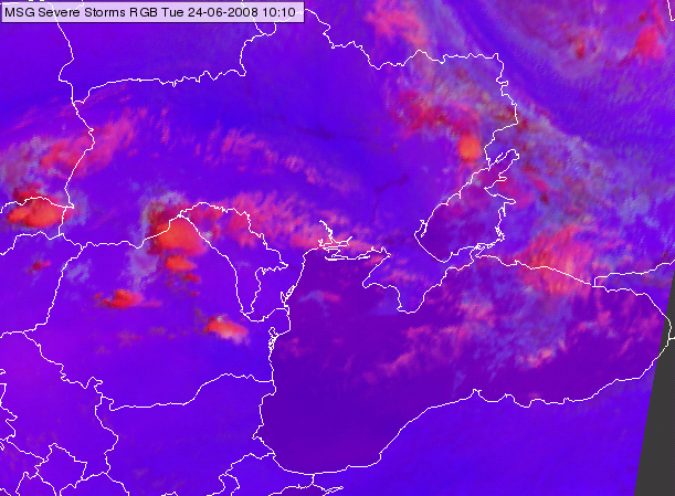
Meteosat, SEVIRI Severe Storms RGB image for 24 June 2008 10:10 UTC
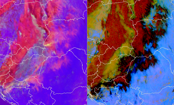
Meteosat, SEVIRI Severe Storms RGB image (left) and Dust RGB (right) for 23 June 2015 12:25 UTC
Although the semitransparent ice clouds are usually pink in the Severe Storms RGB images, there are some exceptions.
• The colour of the very thin cirrus clouds maybe different as it approximates to the colour of the underlying surface or clouds.
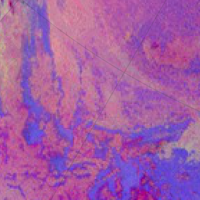
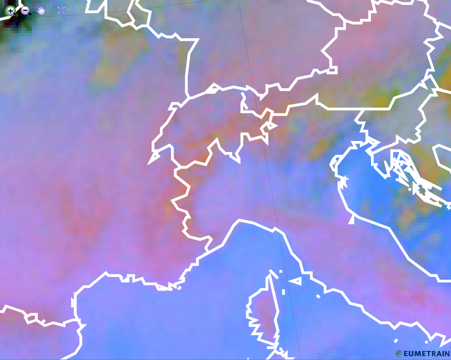
• Semitransparent ice clouds consisting of small ice crystals, like high level lee clouds (see the image below) can appear in other colours (e. g. yellowish, greyish, whitish) because of the increased green component.
Meteosat, SEVIRI Severe Storms RGB images for 16 March 2014 09:40 UTC
Explanation of the colours of the semitransparent clouds (see the recipe):
In case of semitransparent clouds the satellite measures mixed radiation consisting of the radiation emitted or reflected by the semitransparent cloud itself and of the radiation originated from below and transmitted through it. That is why the colour of a semitransparent cloud depends not only on the ice crystal size and temperature but also on the transparency and the colour of the underlying surface.
• The colour of the almost thick semitransparent cloud approximates the colour of the thick ice clouds (red, yellow).
• The colour of the very thin cirrus clouds approximates the colour of the underlying clouds or surface (blue, violet, gray, red or yellow).
• The colour of the thin cirrus is between the colour of the thick ice cloud and that of the underlying cloud or surface. It is usually pink. In case the cirrus cloud consists of very small particles, or the very thin cirrus is over mid layer water cloud then its colour may become closer to grey.
Low and warm water clouds depict in a pink colour in the Dust RGB images.
Pink contains a higher amount of red and blue combined with a lesser amount of green.
The red colour beam consists of the brightness temperature difference (BTD) IR12.0 - IR10.8. This difference is around zero for low-level opaque clouds. Given a temperature range from -4°C to +2°C, the red colour contribution is medium to high.
The BTD (IR10.8 - IR8.7) is ~(2-4 K) for low water clouds. As for the green component a strong gamma correction (with 2.5 gamma) is applied, the green signal becomes medium strong (or a little weaker).
The warmer the clouds, the higher the blue colour contribution. For warm low-level clouds, the blue colour contribution is high.
The Dust RGB image below shows pink low-level clouds over the South-Atlantic.
Dust RGB from 16 February 2016, 06:00 UTC
Explanation of the pink colour of low-level water clouds in the Dust RGB (see the recipe):
• In case of low-level water clouds, red and blue colour beams contribute most, while the green contribution is less strong.
Cold cloud free land depict in a pink colour in the Dust RGB images.
The red colour beam reflects the brightness temperature difference (BTD) IR12.0 - IR10.8. The difference depends on the emissivity of the surface but also on the total water content of the troposphere. Accordingly, the BTD can vary from negative values to positive values (see recipe on the left side). The BT of channel IR12.0 is lower in regions with high humidity and the BTD more negative. The red colour contribution is stronger in case of a dry atmosphere and smaller when the atmosphere is more humid.
As the emissivity of vegetated ground is a little lower at 8.7 micrometer than at 10.8 micrometer, their BTD is small but positive. As for the green component a strong gamma correction (with 2.5 gamma) is applied, the green signal becomes medium.
The colder the surface, the weaker the blue colour contribution. On cold winter days and on cold summer nights the blue colour contribution is small.
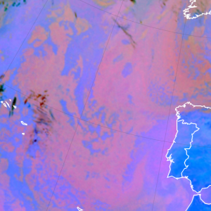
The Dust RGB image below shows a cold summer night over cloud free Ukraine and Russia. Warm rivers and lakes (but also the sea) depict in blue.
Dust RGB from 26 August 2015, 00:00 UTC
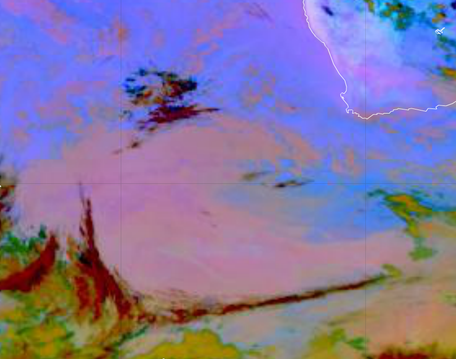
Same date as for the DUST RGB image above, but the Central European region. The Alpine region and the Massif Central depict in a stronger red, while the Po valley shows in a blueish colour. The total water content of the atmosphere over the Alps is smaller than over the Po valley.
Dust RGB from 26 August 2015, 00:00 UTC
Explanation of the pink colour of cold, cloud free land in the Dust RGB (see the recipe):
In case of cold, cloud free (vegetated) land, the red (IR12.0 - IR10.8) colour beam contributes most (with a little bit of green), while the blue contribution is small. The resulting colour is pink.