
magenta
Thin, pure volcanic ash clouds appear typically red or magenta in the Ash RGB images.
The thick volcanic ash cloud is not separable from other thick clouds. However, the ash plume becomes rapidly thinner with increasing distance from the source, and the semitransparent ash cloud is already detectable.
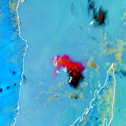
The image below shows one of the eruptions of Karthala volcano on the Grande Comore Island (near Madagascar). The volcano released significant amounts of volcanic ash.
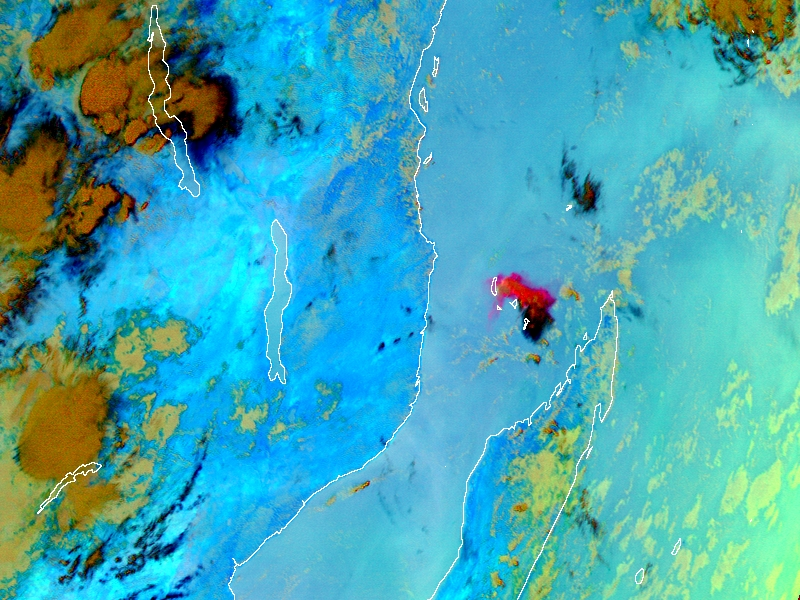
Meteosat, SEVIRI Ash RGB for 25 November 2005 08:00 UTC
The image below shows an eruption of Mount Etna ejecting ash.
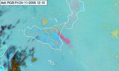
Meteosat, SEVIRI Ash RGB for 24 November 2006, 12:00 UTC
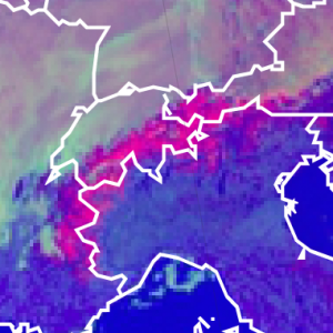
Ash clouds released by the Eyjafjallajökull volcano on Iceland are shown in the next image in reddish colours.
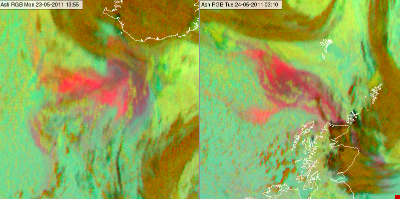
Meteosat, SEVIRI Ash RGB for 23 May 2011, 13:55 UTC (left) and 24 May 2011, 03:10 UTC (right)
The detection of thin ash cloud is particularly effective if the ash plumes
• reach high altitudes where the temperature difference between the ash cloud and the underlying surface is typically larger,
• does not contain significant number of ice particles,
• contain small ash particles.
Note that ash clouds with very mall ash particles at high viewing angles may appear yellow.
Explanation of the colours of thin, pure volcanic ash cloud (see the recipe):
The key channel combination of thin ash cloud detection is the (IR12.0-IR10.8) brightness temperature difference (visualised in the red colour beam). A thin ash cloud is more transparent in the 12.0 micrometer channel than in the 10.8 micrometer channel.
• For thin ash clouds the red component is high, (except the ash plume is mixed with a significant number of ice particles). For thin ice clouds the red signal is low; for thick clouds and cloud free land and sea it is medium strong.
• The green signal is week or medium strong, (except the ash is mixed with SO2 gas or it consists of very small particles and the viewing angles are high).
• The blue signal depends on the temperature and the transmittance of the ash plume, and the temperature of the underlying surface or cloud layer. For colder and denser ash clouds it is low, for warmer ash clouds it is high.
As a consequence the thin, pure ash cloud appears red or magenta (depending on the IR10.8 brightness temperature). It may appear yellow in case the ash particles are very small and the viewing angle is high. If the ash plume is mixed with an SO2 gas plume then it appears yellow.
In the Day Microphysics RGB images the snow covered area appears magenta. The reflectivity of snow is high in the 0.87 micron channel, resulting in a high signal in the red colour beam. The 1.6 micron radiation is absorbed by snow crystals. Hence the reflectivity of snow is low in the 1.6 micron channel, resulting in a low signal in the green colour beam. The temperature of snow cover is close or below 0 ºC causing a medium (or a little weaker) signal in the blue colour beam. As a result the snow will be magenta in the Day Microphysics RGB images (intense red, weak green, medium blue). The actual shade of the colour depends on the temperature (colder snow is more ‘bluish’). The snow cover on the high mountains depicts usually brighter magenta colour, than on the mainland or on the hills, as the snow cover is less disrupted by vegetation on the mountains. See the recipe.
The image below shows the snow covered Alps on 09 March 2014 at 09:45 UTC. Some peaks and ridges in the Apennines, in Corsica and Dinaric Alps are also covered by snow.
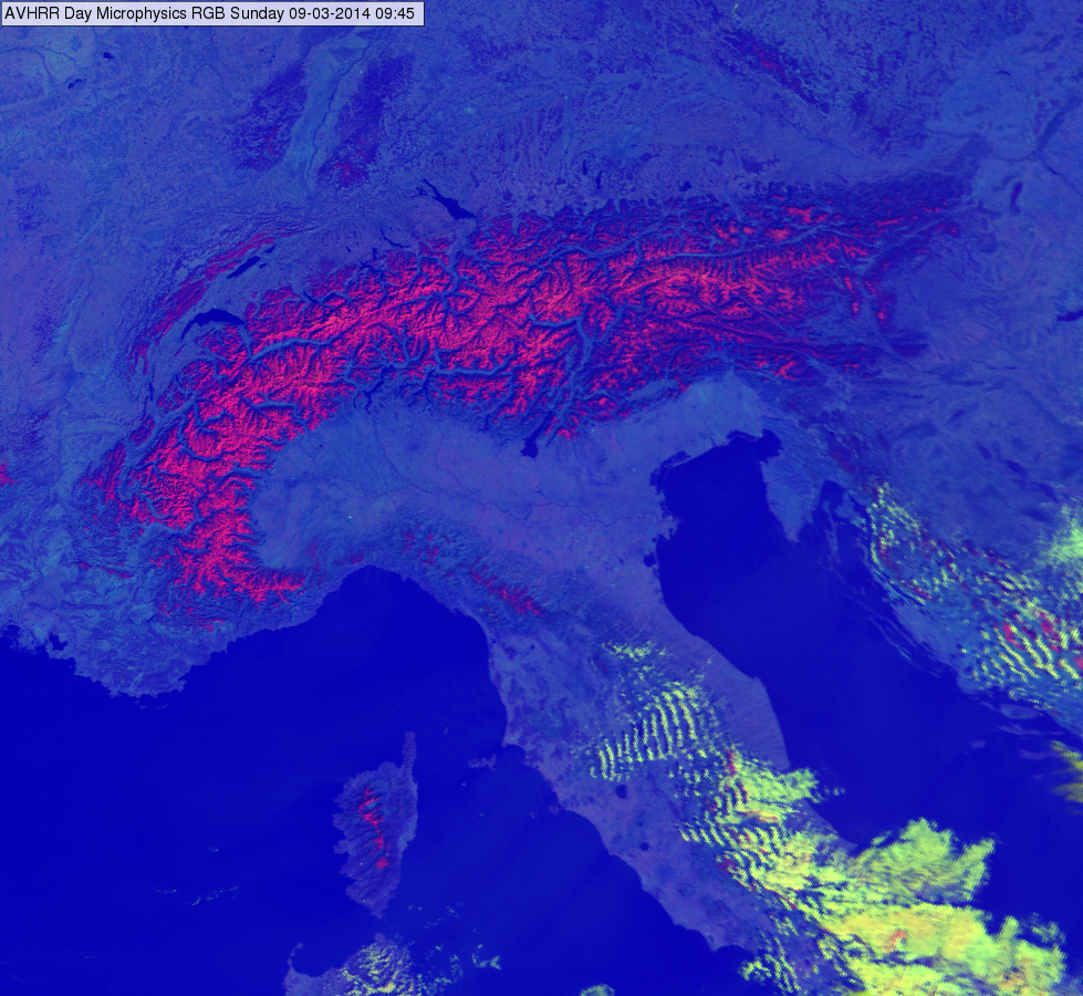
MetOp AVHRR Day Microphysics RGB image, 09 March 2014 09:45 UTC
The following image shows the snow covered Alps, Pyrenees and Massif Central on 07 March 2014 at 09:37 UTC.
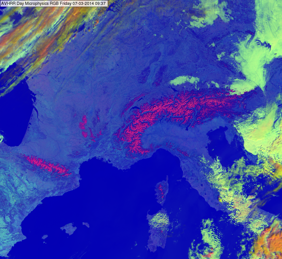
MetOp AVHRR Day Microphysics RGB image, 07 March 2014 09:37 UTC
Cloud free land depicts in magenta colours in the Night Microphysics RGB images.
Magenta is a combination of the red and the blue colour beam.
For the contribution of the red colour beam, the brightness temperature difference (BTD) of the MSG channels (IR12.0 - IR10.8) is around zero when Cirrus clouds are absent. As the used colour scale reaches from -4 (black) to +2 degrees (intensive red), the resulting red colour is of medium intensity.
When there are no low clouds, the green colour beam gives little contribution. The measured BTD (IR10.8 - IR3.9) are small and mainly due to CO2 absorption at 3.9 micrometer.
The blue colour beam is contributing with an average value. The warmer the surface is, the more the radiation from IR10.8 is contributing to the blue colour intensity.
Cloud free sea has a more blueish colour than cloud free land when the sea surface is warm (see image below).
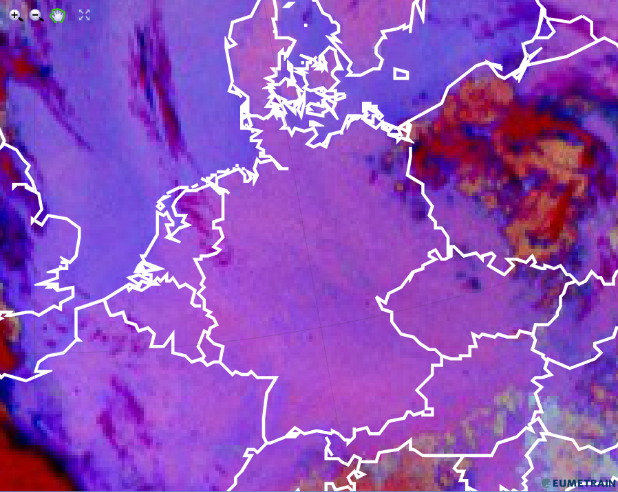
Night Microphysics RGB from 23 August 2015, 00:00 UTC
Explanation of the magenta colour of cloud free land in the Night Microphysics RGB (see the recipe):
For cloud free land, only the red and the blue colour beams contribute (red + blue = magenta)
Snow and ice on the ground appears magenta in the Day Microphysics RGB images.
Magenta is a combination of red and blue. The intensity of the red colour beam comes from the strong reflection of short wave solar radiation at 0.8 micrometer. The more homogenous the snow/ice cover is, the higher will be the red beam contribution. Snow and ice on mountains will therefore be depicted in a stronger magenta colour than snow on ground which is often disrupted by vegetation.
MSG channel IR3.9 barely contributes to the magenta colour of snow in the Day Microphysics RGB. The shortwave solar radiation at 3.9 micrometer is almost completely absorbed by snow and ice.
The IR10.8 channel contributes moderately to the satellite measured radiation as snow and ice on the ground is relatively warm compared to the temperature of clouds. The warmer snow/ice the higher the contribution from the blue colour beam and the more the red colour will turn into magenta.
The Day Microphysics RGB image from early March 2013 shows snow over large parts of Belorussia and the Ukraine. The Carpathian mountains are clearly visible in the Day Microphysics RGB.
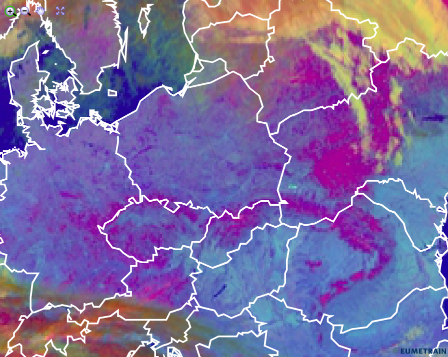
HRV Cloud RGB from 5 March 2013, 12:00 UTC
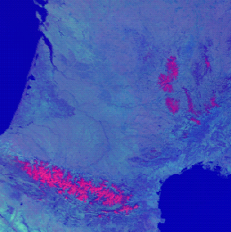
The Day Microphysics RGB image below shows the contrast between uneven snow cover (Hungary, Slovenia, Serbia ...) and the brighter magenta over the Alps. While the contribution from IR10.8 is about the same, the reflectivity measured at 0.8 micrometer is much higher over the Alps.
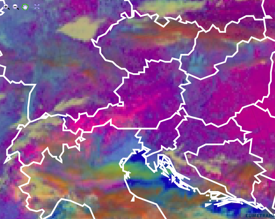
HRV Cloud RGB from 8 February 2012, 12:00 UTC
Explanation of the magenta colour of snow and ice on the ground in the Day Microphysics RGB (see the recipe):
• The magenta colour of ice and snow on the ground is formed by a contribution of VIS0.8 and IR10.8, i.e. by high reflectivity of the short wave solar radiation and by a moderately cold surface.
Sand storms and dust clouds depict in magenta in the Dust RGB images.
The large red contribution for sand and dust in the troposphere depicted in the Dust RGB is due to the fact that long wave radiation from the earth surface is stronger absorbed by a dust layer at 10.8 µm than in 12.0 µm (see image below). It is the other way round for thin ice clouds. A positive brightness temperature difference (BTD) leads to a high red contribution.

The BTD (IR10.8 - IR8.7) is rather small for aerosols like dust, this results in a low contribution of the green colour beam.
The blue contribution is high for warm and low clouds like dust. In the night, the suspended particles are cooler than during daytime; this results in a lower contribution of the blue component during the night . So, the night-time sand storm appears purple (intense red), whereas in daytime it would be magenta (red + blue = magenta).
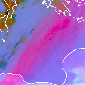
The Dust RGB image below shows a long dust track from western Libya to Greece and Turkey.
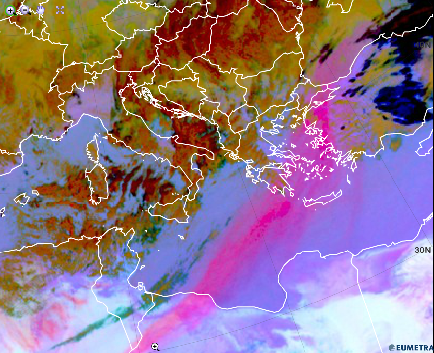
Dust RGB from 1 February 2015, 12:00 UTC
Explanation of the red colour of dust clouds in the Dust RGB (see the recipe):
• In case of a strong dust storm outbreak, a high red and a high blue contribution combine to magenta colour.