
Wave
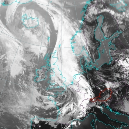
Waves are cloud bulges at the rear edge of Cold Front cloud bands, indicating the initial stage of secondary cyclogenesis.
A Wave development can be treated as a substructure in a Cold Front and indicates the initial stage of cyclogenesis. According to well-known polar front theory a low pressure area in the lower levels of the troposphere can develop if a small-scale disturbance is superimposed on the synoptic-scale air stream. This small-scale disturbance is caused by a transverse circulation within the baroclinic zone of the Cold Front. The transverse circulation is released by frontogenesis in the horizontal wind field that causes a fall in pressure, convergence and the production of cyclonic vorticity in the lower levels of the troposphere at the warm edge of the baroclinic zone. The consequence of this disturbance is that cold air moves south-eastward and warm air moves north-westward; this circulation is superimposed on the eastward-moving front. During this circulation a strengthening of the low pressure area occurs and further development of a new cyclone can be observed. In the case of the cloud bulge of a Wave a small scaled substructure within the stream lines can be observed: a strongly ascending Warm Conveyor Belt accompanies the area of the cloud bulge; a drier stream from behind approaches this relative stream; in the lower isentropic layers relative stream lines immediately south of the Wave form a saddle point - this is a consequence of the cyclonic circulation in the Wave area in the lower layers.