Initial weather situation: 13 May 06.00 UTC
In the 3-hourly sequence of satellite images, the frontal cloud band can be followed as it moves from a position over the western Mediterranean to the Balkan Peninsula.
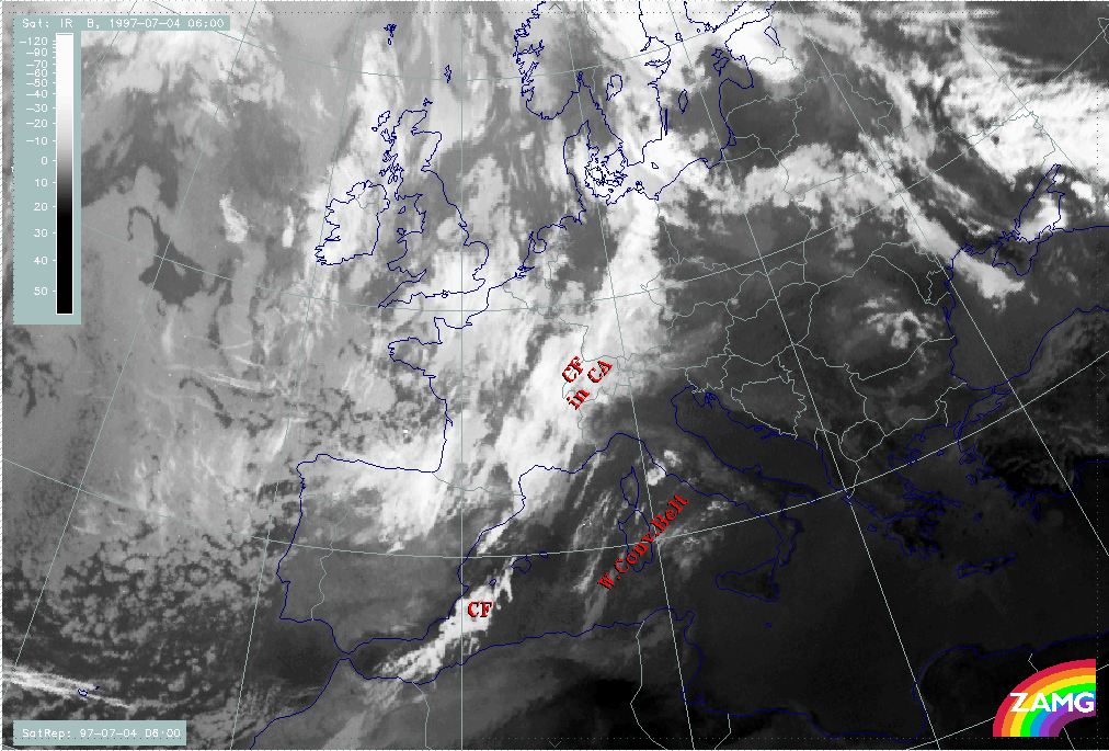
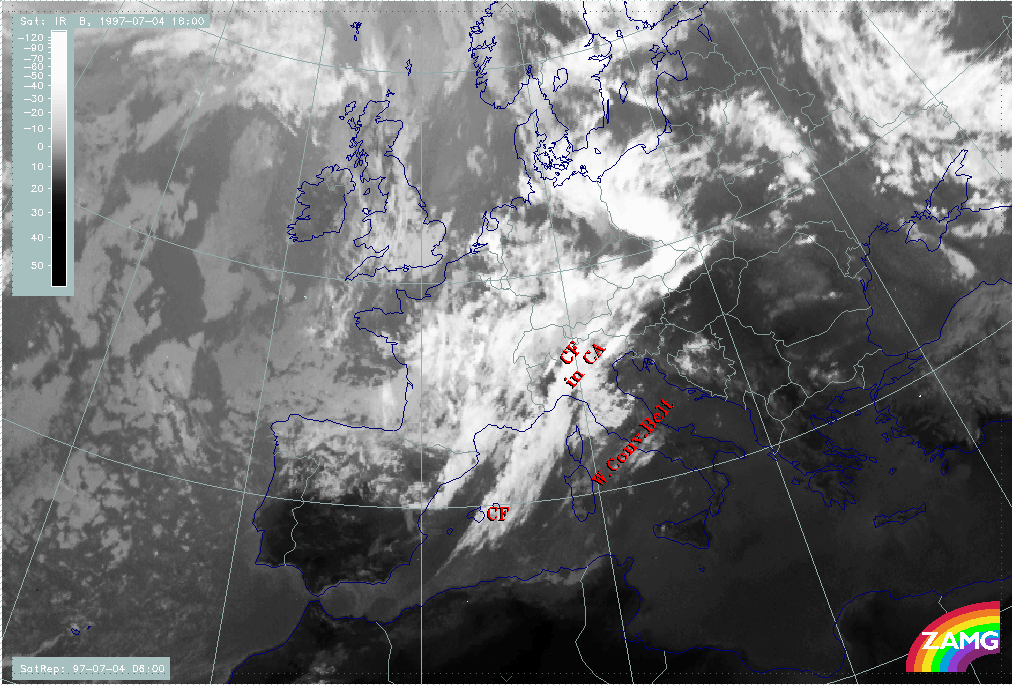
Initially the frontal cloud band extends from the western Mediterranean across Switzerland into Germany. There are some cloud fibres ahead of it over Sardinia which represent a rising warm conveyor belt. A Wave - like feature appears over the west Alps, but does not develop.
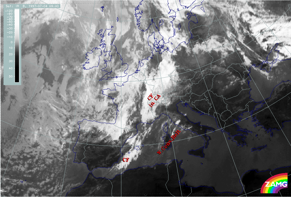
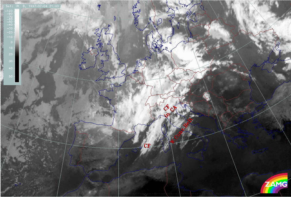
From 09.00 UTC, in addition to the Wave - like feature mentioned above, an intensification over Germany can be recognised which intensifies further and moves into Poland by 21.00 UTC. From then on it splits from the frontal cloud band and can be observed as a separate convective cloud system. This phenomenon is described in detail in the chapter Front intensification by jet crossing: FI by Jet.
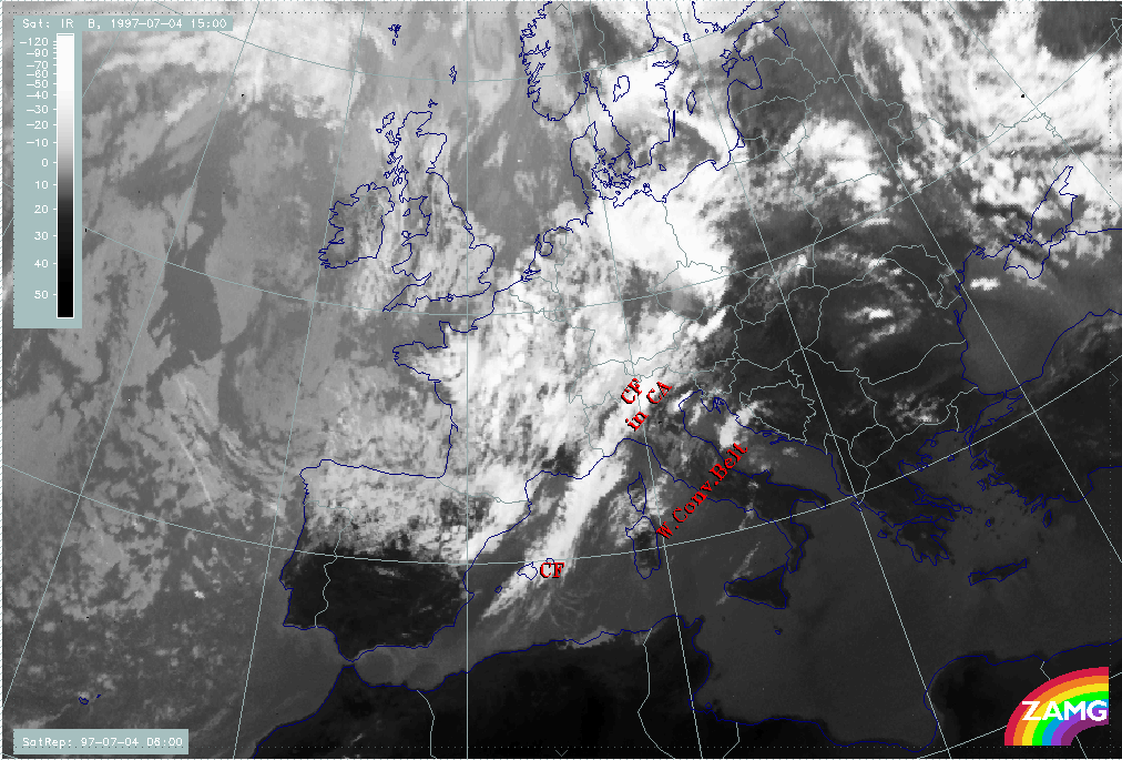
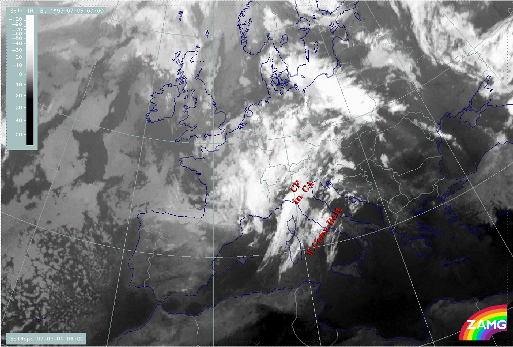
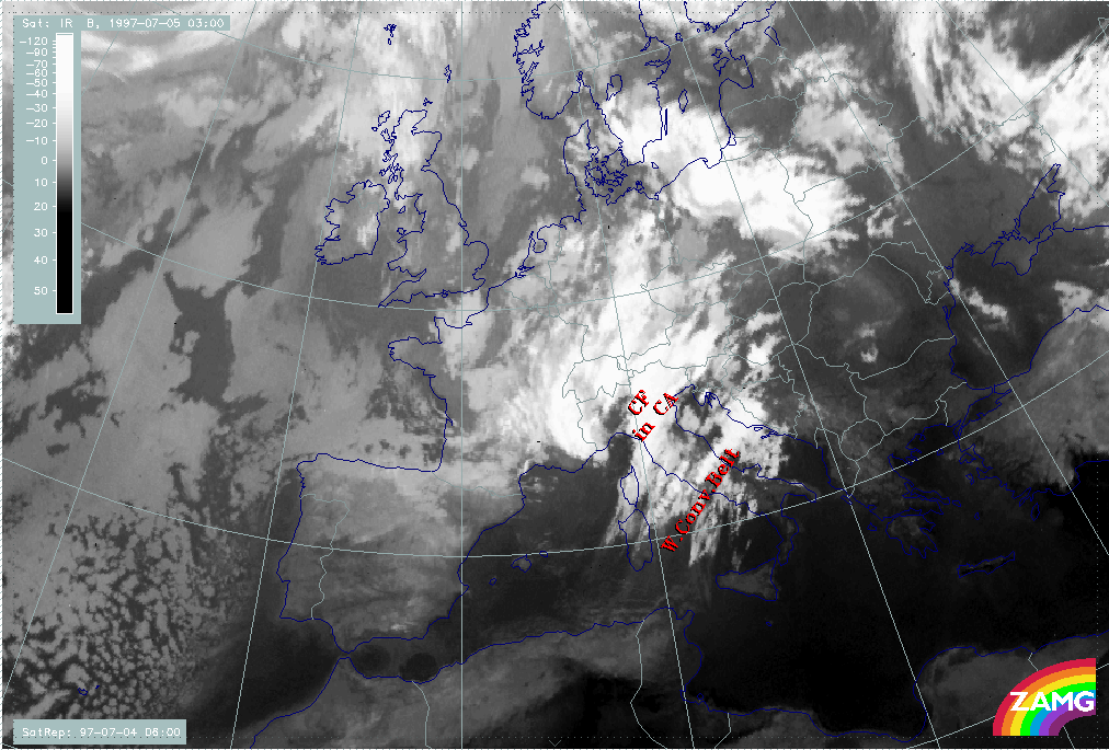
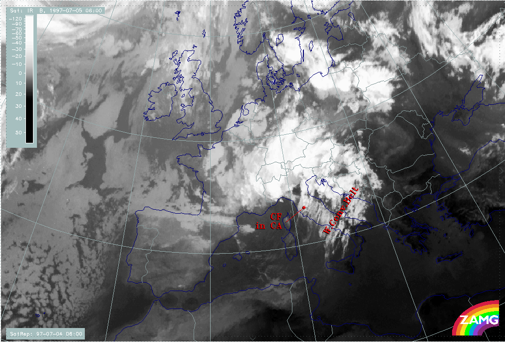
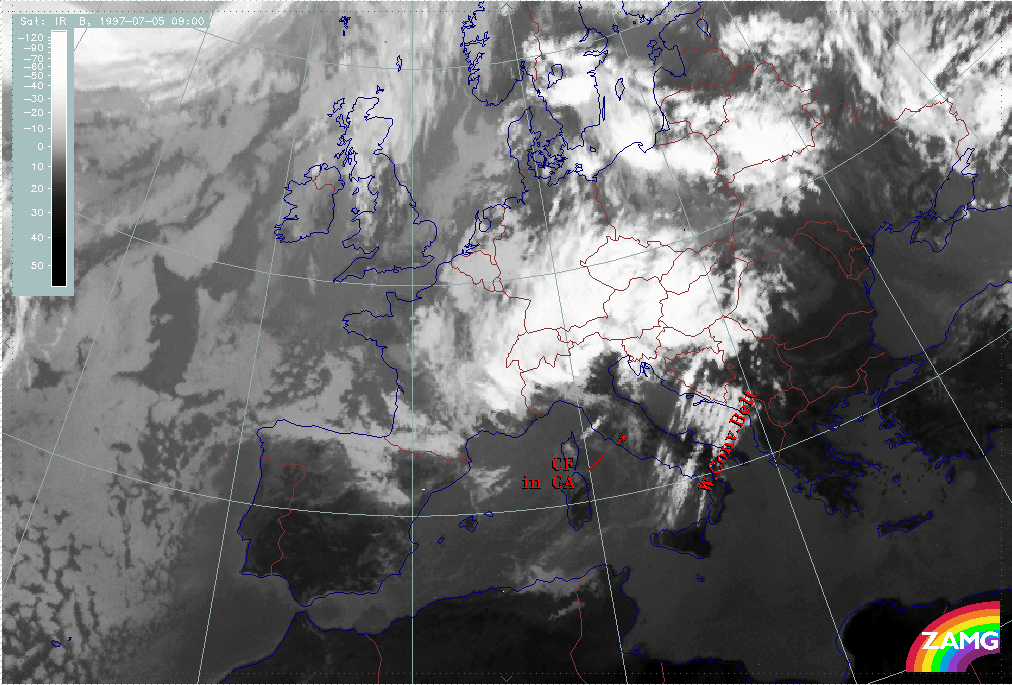
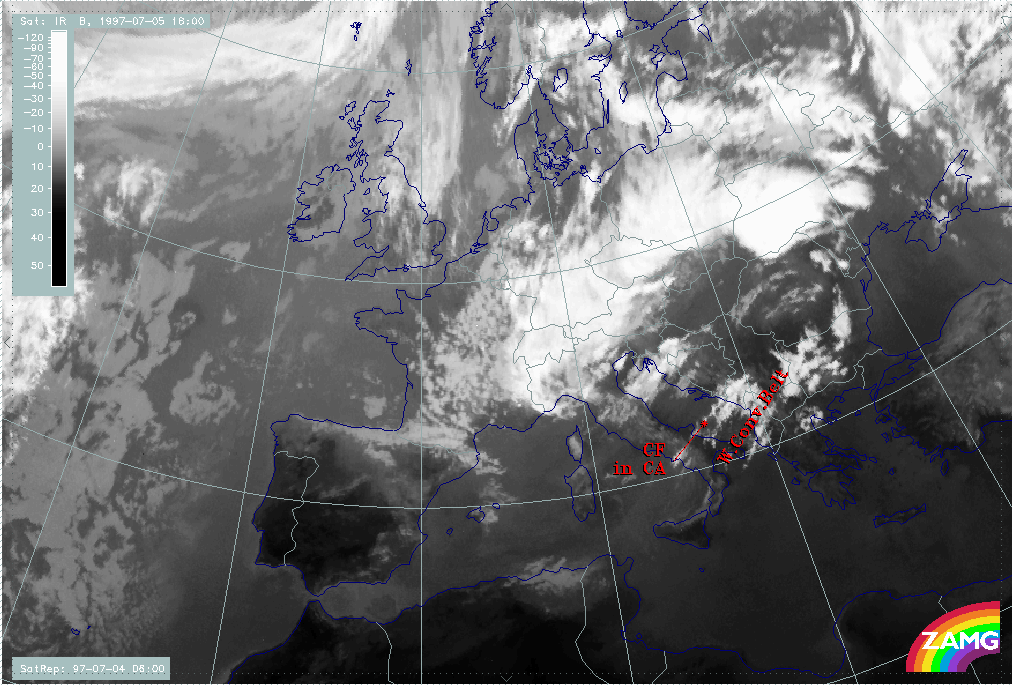
During the passage of the frontal band, the cloud fibres ahead of it indicating a Warm Conveyor Belt can be observed; but from about 21.00 UTC, a distinct intensification of this cloudiness takes place which suddenly leads to the appearance of a very broad frontal cloud band. Indeed, the frontal cloudiness is still at the western boundary. Between 06.00 and 12.00 UTC on 05 July, a dramatic dissolution of this frontal cloudiness takes place, while the cloud fibres belonging to the Warm Conveyor Belt can be observed till the end of this phase at 18.00 UTC.
|
04 July 1997/06.00 UTC - Meteosat IR image; 04/06.00 - 05/18.00 UTC 3-hourly image loop
|
|
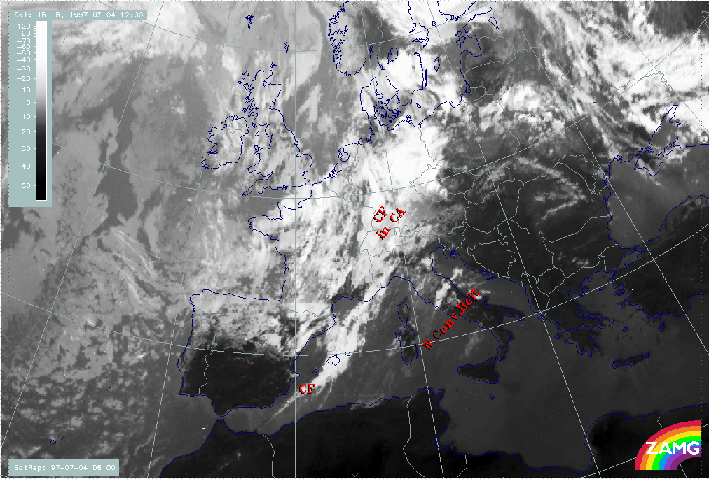
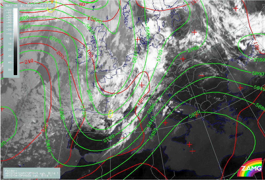
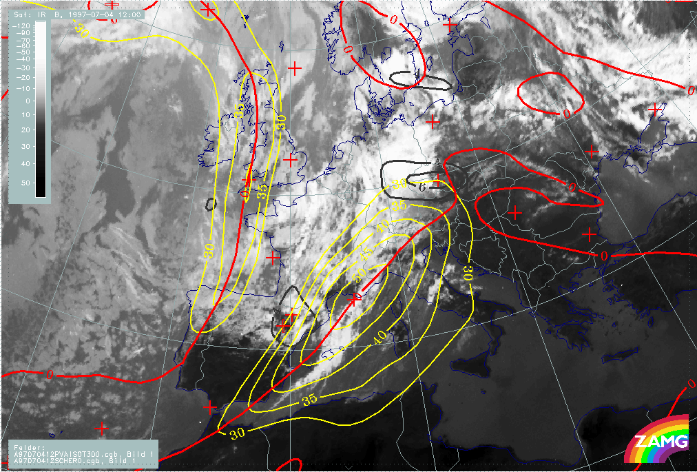
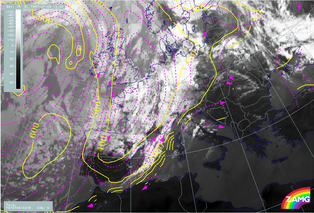
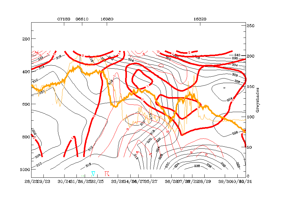
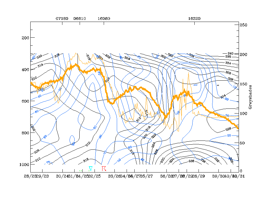
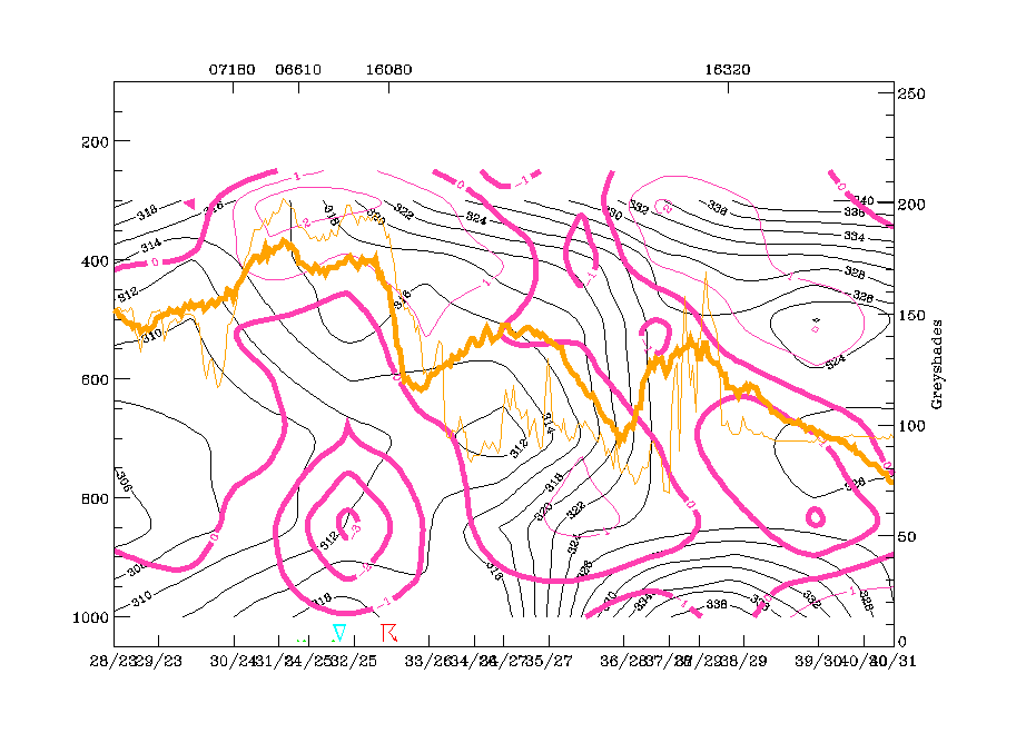
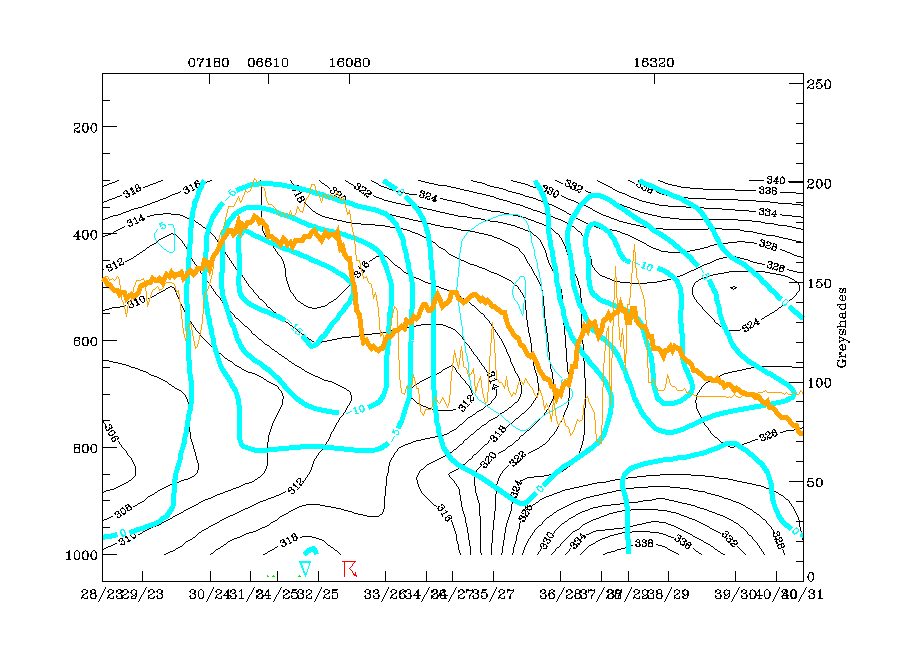
The frontal situation at the start of the event is shown on the image for 04 July/12.00 UTC. At this time, the frontal cloud band is situated within a distinct upper level SW stream and is not accompanied by any trough - like configuration in the surface pressure field. The typical frontal parameters show a rather broad zone with higher thickness gradients compared with the surrounding area which leads to a splitting of the TFP into two branches. The temperature advection (TA) field shows very low values, most of them representing cold advection (CA); this is in accordance with the diagnosis of the conceptual models "Cold Front in Cold Advection". There is a very pronounced jet streak at 300 hPa at the rear side of the frontal cloud band crossing it in the area of the west Alps. Two PVA maxima exceeding the threshold of 4 units exist on the cyclonic side of the jet streak: the northern one is associated with the cloud intensification area over Germany and shear vorticity and is described in detail in the chapter Front intensification by Jet Crossing: FI by Jet; the southern one is associated with the intensified cloudiness over NE Spain and curvature vorticity and is described in detail in the chapter Cold air features;.
|
04 July 1997/12.00 UTC - Meteosat IR image; red: height contours 1000 hPa, green: height contours 500 hPa, yellow: positive vorticity advection (PVA) 500 hPa
|
04 July 1997/12.00 UTC - Meteosat IR image; blue: thermal front parameter (TFP) 500/850 hPa, green: equivalent thickness 500/850 hPa, red solid: temperature advection - WA 1000 hPa, red
solid: temperature advection - CA 1000 hPa, SatRep overlay: names of conceptual models
|
|
|
|
|
|
04 July 1997/12.00 UTC - Meteosat IR image; black: positive vorticity advection (PVA) 300 hPa, yellow: isotachs 300 hPa, red: shear vorticity 300 hPa
|
|
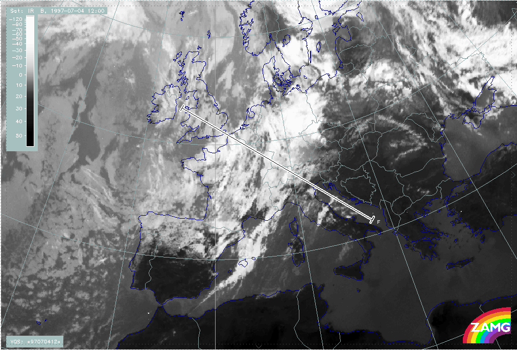
Additional information about the physical state of the frontal cloud band can be gained from the distribution of parameters in the vertical. The vertical cross section line F crosses the front from NW (Wales) to SE (Adriatic Sea).
|
04 July 1997/12.00 UTC - Meteosat IR image; position of vertical cross section indicated
|
|
|
Isentropes, TA and satellite pixel values show different physical states along the cross section:
The main western IR and WV peak pixel values (around radiosonde station 06447, Brussels) indicate the convective cold air feature over NW France and is associated with an unstable area in the isentropes, but there are rather indistinct features in the TA.
The central peak pixel values SE of radiosonde station 07180 (Reims) represent the frontal cloudiness. There is a downward inclined zone of high gradients in isentropes from 400 hPa down to the surface with a superadiabatic behaviour below 800 hPa. The whole area is under CA, which supports the diagnosis of the cloud band as Cold Front in Cold Advection.
Immediately south-east of the frontal zone around the radiosonde station 16044 (Udine), again a very unstable layer from the surface up to about 600 hPa exists. On top of this layer an upper level frontal zone of high gradients can be observed which is also under CA, too. This is in coincidence with the area of the cloud fibres marking a Warm Conveyor Belt.
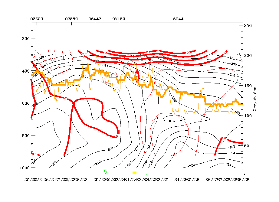
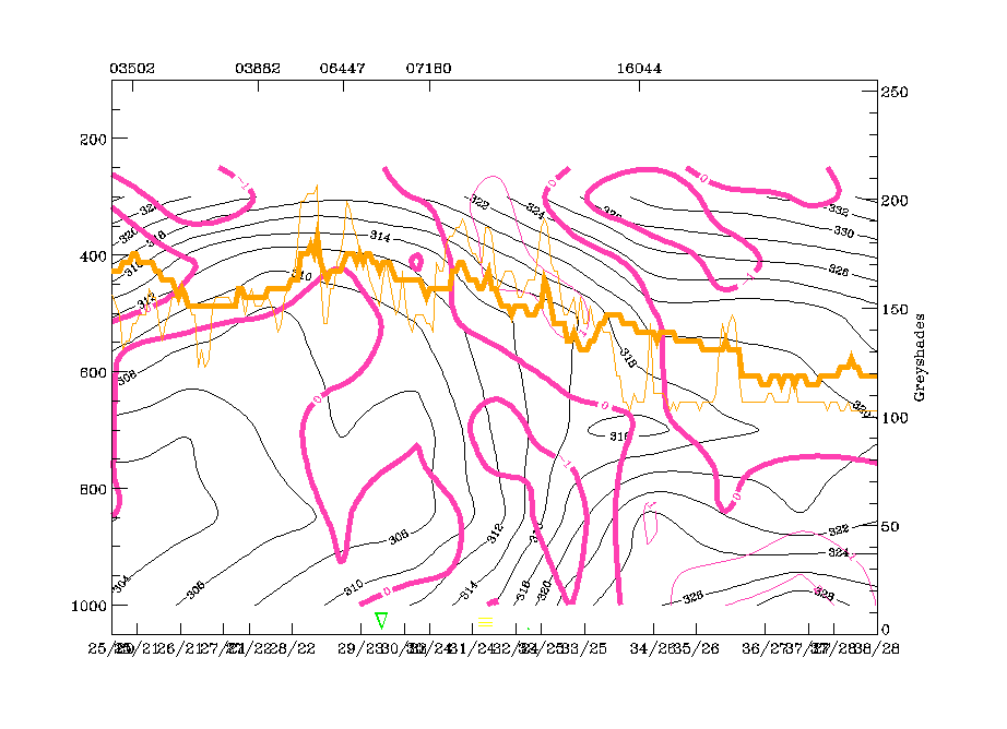
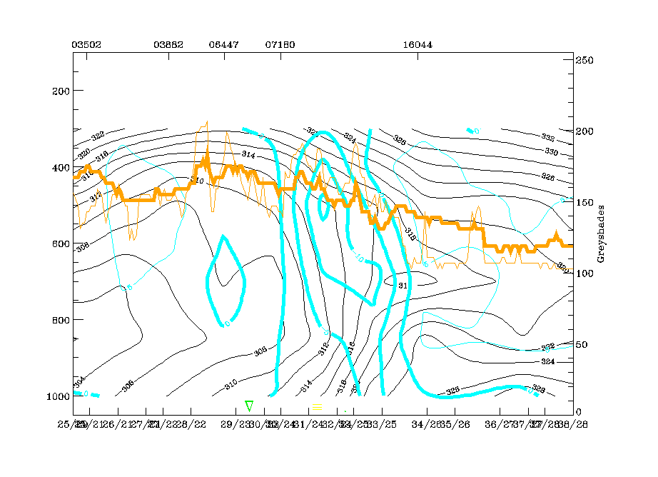
The vertical distribution of divergence and upward motion supports the idea of two frontal circulation zones:
- The main one, with convergence within, divergence above the frontal zone of high gradients leading to intensive upward motion there
and
- An upper level frontal zone which is accompanied by distinct convergence but with no significant upward motion.
|
04 July 1997/12.00 UTC - Vertical cross section; black: isentropes (ThetaE), red thin: temperature advection - CA, red thick: temperature advection - WA, orange thin: IR pixel values,
orange thick: WV pixel values
|
04 July 1997/12.00 UTC - Vertical cross section; black: isentropes (ThetaE), magenta thin: divergence, magenta thick: convergence, orange thin: IR pixel values, orange thick: WV pixel
values
|
|
|
|
|
|
04 July 1997/12.00 UTC - Vertical cross section; black: isentropes (ThetaE), cyan thick: vertical motion (omega) - upward motion, cyan thin: vertical motion (omega) - downward motion,
orange thin: IR pixel values, orange thick: WV pixel values
|
|
Relative streams on isentropic surfaces give some further insight into the distribution and approach of different air masses (e.g. conveyor belts). The 318K surface is very high above the Cold Front zone and immediately above the unstable zone to the south-east. In the development and maintenance of the Cold Front cloud band a rising Warm Conveyor Belt as well as an upper level stream and a dry intrusion are involved. They are rather classically distributed, and a large part of the frontal cloud band has developed within the Warm Conveyor Belt.
There is already some indication of cloud fibres and relative streams over Italy being parallel to each other. This is the area where cloudiness is going to develop which is discussed below.
|
04 July 1997/12.00 UTC - Meteosat IR image; magenta: relative streams 318K - system velocity 245° 9 m/s; yellow: isobars
|
|
|
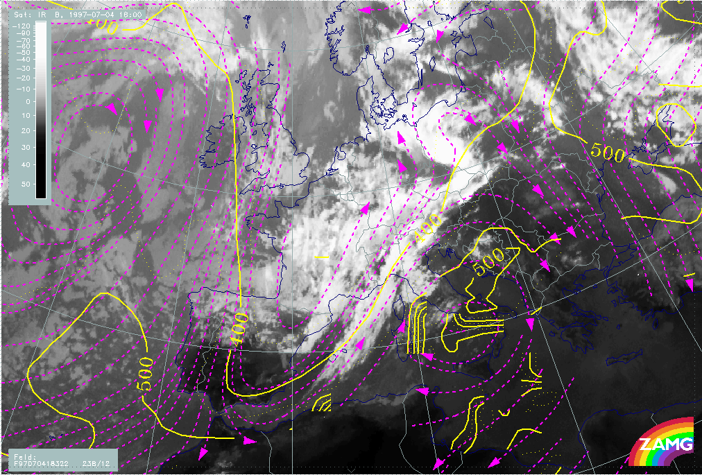
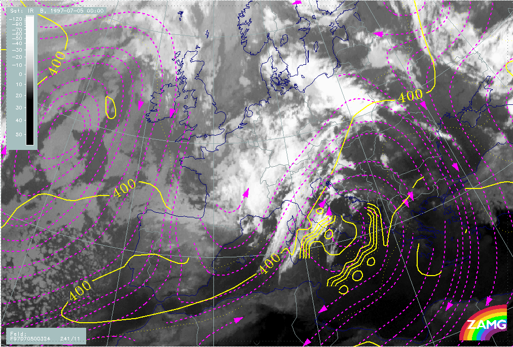
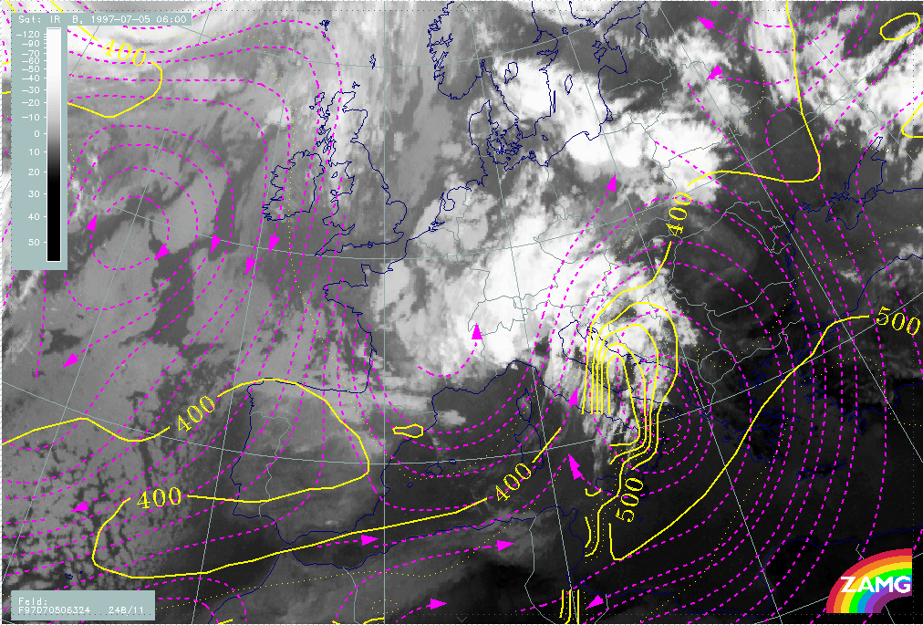
A distinct intensification of the Warm Conveyor Belt over Italy as well as an increase in cloudiness in its rising branches is very well shown in the analysis of relative streams between 04 July/18.00 UTC and 05 July/06.00 UTC.
|
04 July 1997/18.00 UTC - Meteosat IR image; magenta: relative streams 322K - system velocity 238° 12 m/s; yellow: isobars
|
05 July 1997/00.00 UTC - Meteosat IR image; magenta: relative streams 324K - system velocity 241° 11 m/s; yellow: isobars
|
|
|
|
|
|
05 July 1997/06.00 UTC - Meteosat IR image; magenta: relative streams 322K - system velocity 248° 11 m/s; yellow: isobars
|
|
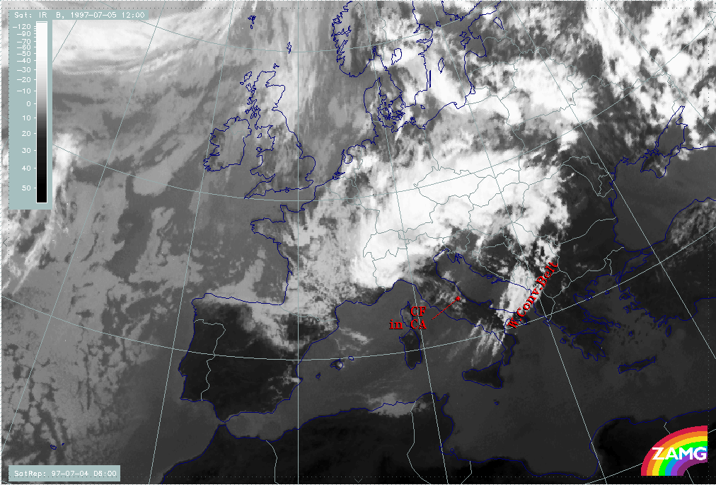
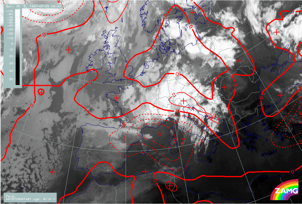
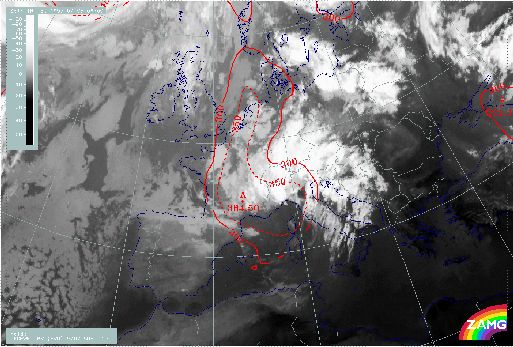
After the period of cloud intensification in the Warm Conveyor Belt, a very rapid dissolution of frontal cloudiness takes place in the short period between 05 July/06.00 and 05 July/12.00 UTC. This goes hand in hand with an intensification of CA starting at 05 July/00.00 in the western Mediterranean and approaching the Balkan Peninsula by 06 July/00.00 UTC. CA between 06.00 and 12.00 UTC as well as Potential Vorticity (in form of the height of the PV=2 units) show a fast eastward propagation of colder and dry air over the CF band.
|
05 July 1997/06.00 UTC - Meteosat IR image; red solid: temperauture advection - WA, red dashed: temperauture advection - CA
|
05 July 1997/06.00 UTC - Meteosat IR image; red: height of PV=2 units
|
|
|
|
|
|
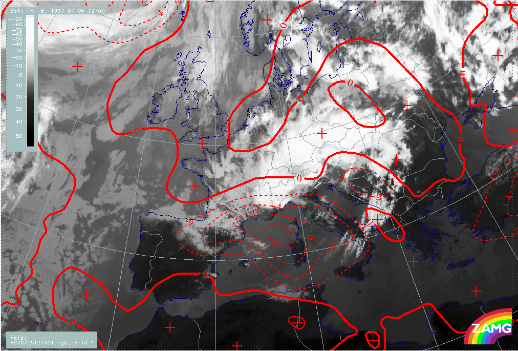
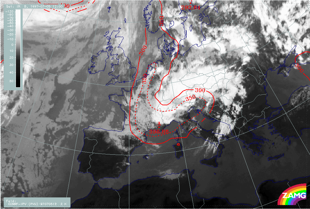
05 July 1997/12.00 UTC - Meteosat IR image; red solid: temperauture advection - WA, red dashed: temperauture advection - CA
|
05 July 1997/12.00 UTC - Meteosat IR image; red: height of PV=2 units
|
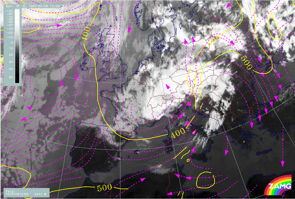
The situation of 05 July/12.00 UTC shows the end phase of the frontal cloud band, but with still some fibrous cloudiness in the Warm Conveyor Belt but only a few remnants of frontal cloudiness.
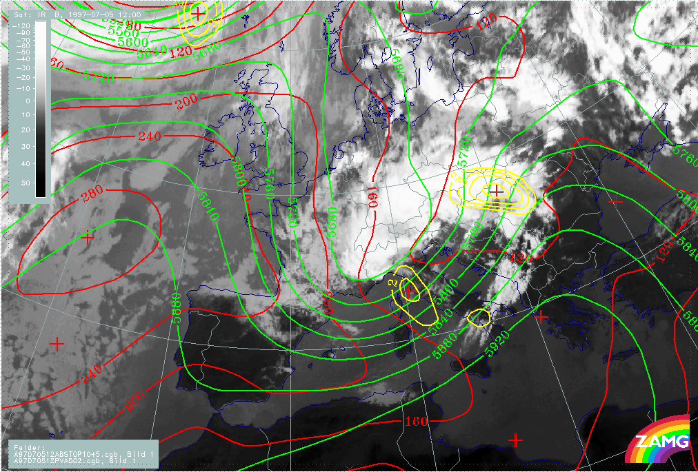
The overall pressure height field and its relation to cloudiness is very similar to 12 hours earlier: A broad SW stream in advance and no distinct trough or low in the surface (1000 hPa). In contrast to the initial stage, however, some distinct PVA maxima are now present.
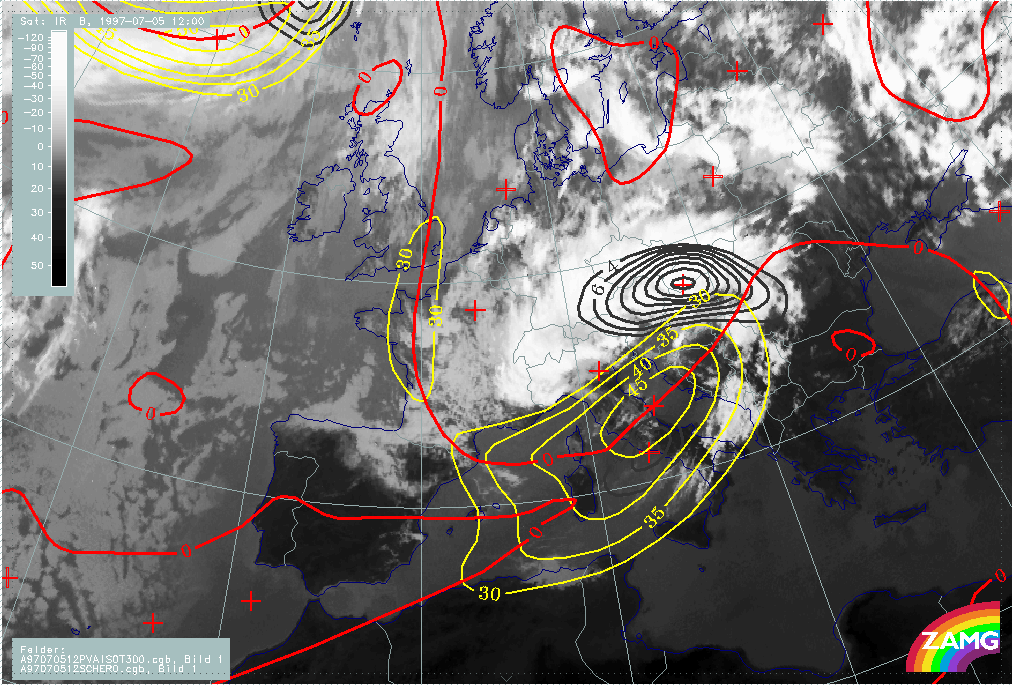
The most dramatic change in the typical frontal parameters is the intensive increase of CA in the Mediterranean and, to some extend, over the Balkan Peninsula which is the area of largely dissolved Cold Front cloudiness. The jet streak at 300 hPa is still very dominant as well as the PVA maximum at 300 hPa in the left exit region.
|
05 July 1997/12.00 UTC - Meteosat IR image; red: height contours 1000 hPa, green: height contours 500 hPa, yellow: positive vorticity advection (PVA) 500 hPa
|
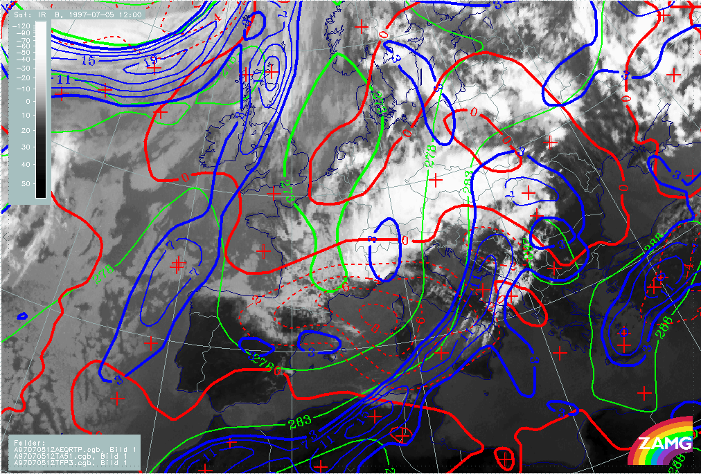
05 July 1997/12.00 UTC - Meteosat IR image; green: equivalent thickness 500/1000 hPa, red solid: temperature advection - WA 1000 hPa, red dashed: temperature advection - CA 1000 hPa,
blue: Thermal Front parameter (TFP) 500/850 hPa
|
|
|
|
|
|
05 July 1997/12.00 UTC - Meteosat IR image; yellow: isotachs 300 hPa, red: shear vorticity 300 hPa, black: positive vorticity advection (PVA) 300 hPa
|
|
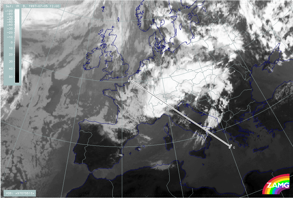
To add information in the vertical, a vertical cross section is computed from NW (France) to SW (Greece) across the Occlusion - like cloud band (see chapter Development of Occlusion - like cloud features), the nearly dissolved frontal cloudiness and the rest of the Warm Conveyor Belt cloudiness.
|
05 July 1997/12.00 UTC - Meteosat IR image; position of vertical cross section indicated
|
|
|
Isentropes, TA and satellite signals show different atmospheric systems along this cross section:
The main IR and WV peak pixel values between the radiosonde stations 07180 (Reims) and 16080 (Milan) indicate the Occlusion - like cloud band and appear in an area of high instability up to 600 hPa as well as an Occlusion - like isentropic trough above. Near the main front there is an almost vertically inclined zone of high gradients where there are rather low IR values; some single peaks represent the rest of the frontal cloudiness. The higher peaks close to the radiosonde station 16320 (Brindisi) belong to the warm conveyor belt; the upper level frontal zone detected 12 hours before has now merged with the main frontal zone. This is supported by the TA field showing intensive CA from the surface up to 600 - 500 hPa but WA above. The relative humidity field shows a very dry area between upper and middle levels exactly in the area of the rest of the frontal cloudiness.
Looking at the parameter divergence, there is a new upper level front with a backbent zone of convergence accompanying the frontal zone of high gradients from 600 hPa upwards.
The two most remarkable features in the omega field are the area of strong subsidence over the frontal zone and the area of strong upward motion in the Warm Conveyor Belt cloudiness. So a comparison with the same charts 12 hours earlier clearly shows transition from upward to downward motion in the region of the frontal cloudiness.
|
05 July 1997/12.00 UTC - Vertical cross section; black: isentropes (ThetaE), red thin: temperature advection - CA, red thick: temperature advection - WA, orange thin: IR pixel values,
orange thick: WV pixel values
|
05 July 1997/12.00 UTC - Vertical cross section; black: isentropes (ThetaE), orange thin: IR pixel values, orange thick: WV pixel values
|
|
|
|
|
|
05 July 1997/12.00 UTC - Vertical cross section; black: isentropes (ThetaE), magenta thin: divergence, magenta thick: convergence, orange thin: IR pixel values, orange thick: WV pixel
values
|
05 July 1997/12.00 UTC - Vertical cross section; black: isentropes (ThetaE), cyan thick: vertical motion (omega) - upward motion, cyan thin: vertical motion (omega) - downward motion,
orange thin: IR pixel values, orange thick: WV pixel values
|
At this point in time, relative streams on isentropic surfaces also give some more insight into the distribution and approach of different air masses (conveyor belts). The 322K surface is very high above the frontal zone dropping very steeply within the new upper level front (Warm Conveyor Belt). Compared to the relative streams 12 hours earlier, only the dry stream from behind the front can now be recognised which is overrunning the frontal cloud band, resulting in its gradual disappearance.
|
05 July 1997/12.00 UTC - Meteosat IR image; magenta: relative streams 322K - system velocity 247° 8 m/s; yellow: isobars
|
|
|