
Identify and interpret broad scale, synoptic and mesoscale systems
This lecture is about conceptual models connected to strong convective processes.
This lecture is about conceptual models connected to strong convective processes. For easier detection and understanding of these clusters, Key parameters are introduced. Most of times there is (Equivalent) Thickness (e.g between 1000 and 500hPa) given along with Potential (Wet Bulb) Temperature at 850 hPa, and together they present parameters for detection of warm areas in Troposphere suitable for convective processes. Low Level Convergence is a key parameter used for detection of areas of high convergence, thus triggering convective areas. Of course, Instability indices are given to track the areas of unstable atmosphere also suitable for cloud development. Some of the physical background and examples of convective processes is shown it this lecture, with help of Satmanu module and satellite images. Also one of the convective cloud features known as a Spanish Plume is descirbed, along with four main types of thunderstorms (Single call, Multicell cluster, Multicell line and Supercell). Presenter of this lecture is Frans Debie, from KNMI.
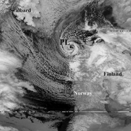
Polar Lows are generally characterized by a severe weather in form of a strong winds, showers and occasionally heavy snow, which had sometimes resulted in lost of lives, especially on the sea area.
Polar Lows are generally characterized by a severe weather in form of a strong winds, showers and occasionally heavy snow, which had sometimes resulted in lost of lives, especially on the sea area. Sometimes these systems are also connected with term Arctic Hurricane, which had been used for especially intense Polar lows. Compromising definition of Polar low is small, but fairly intense low in maritime regions. They are formed in cold air outbreaks, north of the polar front, mostly in the regions east of 0°E and south of 75°N. Favorable season for them is cold part of the year. By size, they are smaller than the ordinary synoptic lows (200-600 km) with the life-span typically around 18 hours, and with very intense change of weather. As it is said before, within these Polar lows very strong winds can occur (15-25 KT, max. 52 KT) so understanding of these systems is of a great safety (and other) importance. All these facts and very nice example of Polar lows are presented by Justyna Wodziczko, from Norwegian Meteorological Institute.
There are three types of thunderstorms; Single-cell, Multi-cell and Supercell. And they all need some ingredients like warm and moist air at low levels, cool and dry air at upper levels, upper level divergence and synoptic scale disturbance.
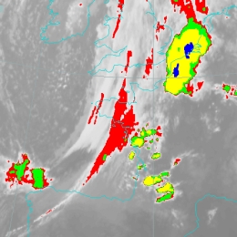
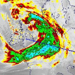
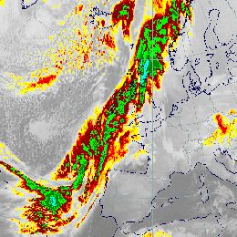
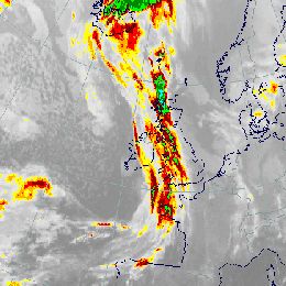
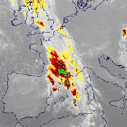
This presentation consist of several parts. It is starting with some words about basics of convective storms and then case study analysis are introduced, with weather charts, radio-sounding data and satellite images. There are three types of thunderstorms; Single-cell, Multi-cell and Supercell. And they all need some ingredients like warm and moist air at low levels, cool and dry air at upper levels, upper level divergence and synoptic scale disturbance. Squall lines, heavy rain and thunderstorms , mostly in the central part of Lithuania were reported at the night of 8th of August 2011. The strongest wind gusts reached even 30 m s-1 and exceeded the value of 60 m s-1 in the major parts of the country. Supercell also did the damage of €7.000.000 to a local forest, and even four casualties were suffered.
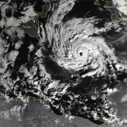
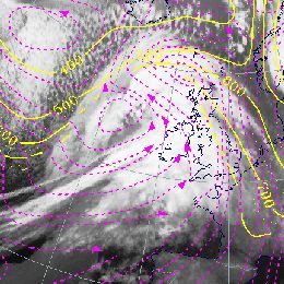
Lecture on unusual cyclogenesis taking place in the Mediterranean basin on 7 and 8 November 2011.
This case study took place in Mediterranean basin from 7th to 8th November 2011, with some interesting weather phenomena occurred there. It is shown that the sequential cloudiness type bands were; not organized convective system in the first step, then Comma feature in the next step, deep convection and finally occlusion. Because of confusing weather features connected to it, this weather phenomenon can not be classified as Tropical Cyclone nor as Rapid Cyclogenesis. The case is treated only from a synoptic point of view, using Meteosat-9 satellite images and ECMWF numerical fields from ePort web site and other graphical elaborations with Metview.
Recorded powerpoint explaining what conceptual models and why we use them throughout.
A ten minute recorded powerpoint including audio and explaining you on what conceptual models are and why we use them in many of the training resources of EUMeTrain. The powerpoint also shows examples from Sat Manu and provides you the basis to go to satreponline.org and learn this technique in more details.
This case study a pronounced frontal system over west and central Europe causing strong precipitation.
Pronounced frontal system over West and Central Europe, causing strong precipitation. All associated Conceptual Models and the development of a Back Bent Occlusion are addressed in detail.
This case study treats a dominating cold front over Western Europe.
This case study shows a dominating cold front over Western Europe. Special attention is drawn to the substructures within the frontal cloud band associated with the jet streak: Front Intensification and Wave.
This case study shows an extended long frontal cloud band west of Europe consisting of cold front in cold advection and cold front in warm advection is diagnosed.
This case study shows an extended long frontal cloud band west of Europe consisting of cold front in cold advection and cold front in warm advection is diagnosed. Frontal substructures and a succeeding rapid cyclogenesis over the Atlantic are analysed.
This case study shows a cold front with a distinct wave over France and a special investigation about a rapid cyclogenesis over the northern Atlantic.
This case study shows a cold front with a distinct wave over France and a special investigation about a rapid cyclogenesis over the northern Atlantic.
This case study shows a pronounced frontal system over the Atlantic and western Europe.
This case study shows a huge frontal system over the Atlantic and western Europe. A rapid cyclogenesis is associated with this system but deviating from the initial CM.
This case study treats a cold front containing strong convective activity over Western Europe.
This case study shows a cold front containing strong convective activity over western Europe. The development and life cycle of the convective cloud features are examined in detail.
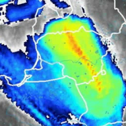
Flood catastrophe in Central and Eastern Europe due to an Upper Level Low.
Flood catastrophe in Central and Eastern Europe due to an Upper Level Low. Convective precipitation and barrage effects lead to extraordinary precipitation events.